Blizzard warnings in western MN, morning rain to p.m. snow in the metro
A powerful low-pressure system will track from northern Iowa to western Wisconsin today. Winds will gust over 45 mph in many parts of western Minnesota, and heavy snow will reduce visibilities to 1/4 mile or less.
Blizzard warnings are in effect until 9 p.m. for western Minnesota, and extend as far east as Meeker and Stearns counties:

A winter storm warning for heavy snow and strong winds extends from central Minnesota into northeastern Minnesota:

Here is a summary of warnings from the Twin Cities NWS office:
Create a More Connected Minnesota
MPR News is your trusted resource for the news you need. With your support, MPR News brings accessible, courageous journalism and authentic conversation to everyone - free of paywalls and barriers. Your gift makes a difference.
NATIONAL WEATHER SERVICE TWIN CITIES/CHANHASSEN MN
432 AM CST FRI NOV 18 2016
...SNOW IS QUICKLY DEVELOPING OVER WESTERN MINNESOTA...
...BLIZZARD CONDITIONS ARE EXPECTED TO BEGIN BY MID MORNING...
.A BLIZZARD WARNING IS IN EFFECT TODAY FOR MUCH OF WEST CENTRAL
MINNESOTA...MAINLY WEST OF REDWOOD FALLS TO ST CLOUD AND
LONG PRAIRIE. THIS AREA WILL SEE THE DEVELOPMENT OF BLIZZARD
CONDITIONS BY MID MORNING AS NORTHWEST WINDS OF 30 TO 40 MPH WITH
GUSTS T0 55 MPH COMBINE WITH HEAVY SNOW. THIS WILL CAUSE
CONSIDERABLE BLOWING SNOW AND WHITEOUT CONDITIONS WITH TRAVEL
BECOMING VERY DIFFICULT OR IMPOSSIBLE.
EAST OF THE BLIZZARD AREA...WINTER STORM WARNINGS AND WINTER
WEATHER ADVISORIES ARE IN EFFECT WHERE SNOW AMOUNTS WILL BE LESS.
THE WINTER STORM WARNING INCLUDES MORRISON...BENTON...MILLE
LACS...AND KANABEC COUNTIES. THE WINTER WEATHER ADVISORY IS IN
EFFECT FOR MUCH OF SOUTH CENTRAL AND EAST CENTRAL MINNESOTA...
INCLUDING THE MAJORITY OF THE TWIN CITIES METRO AREA AND MANKATO.
SNOW WILL INCREASE IN INTENSITY ACROSS WESTERN MINNESOTA EARLY
THIS MORNING AND BECOME HEAVY AT TIMES INTO EARLY AFTERNOON BEFORE
TAPERING OFF BY EVENING. ACROSS CENTRAL AND EASTERN MINNESOTA...RAIN
AND A FEW THUNDERSTORMS WILL CHANGE TO SNOW BY EARLY THIS
AFTERNOON. SNOW ACCUMULATIONS OF 6 TO 12 INCHES ARE EXPECTED WEST
OF A LINE FROM REDWOOD FALLS TO ST CLOUD AND LAKE MILLE LACS WITH
THE HEAVIEST AMOUNTS OVER DOUGLAS...TODD...AND MORRISON COUNTIES.
AMOUNTS WILL TAPER OFF QUICKLY TO THE EAST...WITH 1 TO 3 INCHES
EXPECTED IN EASTERN PARTS OF THE ADVISORY AREA INCLUDING THE TWIN
CITIES METRO.
You can click on the National Weather Service warning maps at NWS Twin Cities, NWS Duluth, NWS Grand Forks, and NWS Sioux Falls to get specific warning information for your location.
Timing of the snow
It is snowing in western Minnesota this morning, but southeastern Minnesota and the Twin Cities will see some morning rain, and possibly a thunderstorm.
At noon, the low pressure system is expected to be just southeast of the Twin Cities, with the rain/snow line just to the northwest of the metro area:

The northwest part of the metro area should see a changeover to snow early this afternoon, with the southeast metro seeing a changeover by mid-afternoon.
At 6 p.m., snow will still be falling over much of Minnesota:

Snow totals today will be highest from central Minnesota into northeastern Minnesota, where 8 to 12 inches are possible:
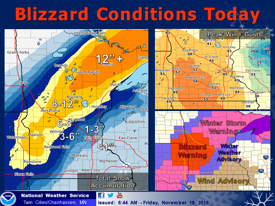
Parts of northeastern Minnesota could see over a foot of snow before it tapers off tonight.
In the Twin Cities metro area, an inch or two of snow is possible, especially on grassy areas. Far northwestern parts of the metro area could pick up as much as 3 inches of snow.
The winter weather advisory for the Twin Cities goes to 9 p.m., due to snow this afternoon/early evening and reduced visibilities. Winds could gust over 40 mph at times.
You can hear updates on this winter storm throughout today on the Minnesota Public Radio network, and you can read about the storm at mprnews.org and the Updraft blog.
We'll have the severe weather live blog on our front page. Please share your photos and storm reports with our Public Insight Network and we can include them in our coverage.