Summer takes hold: Near 90 by Tuesday?
Timing is everything.
If I ruled the master weather switch in the Weather Lab could I get consensus on when to make it rain? How warm today? Mostly sunny with a few decorative clouds?

Thankfully that weather fantasy will never become reality in our lifetimes. That's probably a good thing. We seem to be good enough at making mountains out of sometimes trivial differences. Imagine congress, or Minnesota politics if we could control the weather.
This weekend may work out favorably for most Minnesotans. A cloud sun mix Saturday. Most of the rain at night? A damp start Sunday morning giving way to a brilliant afternoon with temps pushing 80 degrees for Grand Old Days in St. Paul?
Create a More Connected Minnesota
MPR News is your trusted resource for the news you need. With your support, MPR News brings accessible, courageous journalism and authentic conversation to everyone - free of paywalls and barriers. Your gift makes a difference.
Summer creeps in on cat's paws next week. It may be enough to renew your faith in Minnesota's weather.
Yes, summer is one big reason why we live in Minnesota.

This weekend may turn out better than the maps indicate. If the timing is right, most of the rain with our inbound frontal system will happen Saturday night.
Skies clear Sunday, as a warmer summer like air mass eases in from the west. If skies clear on cue Sunday afternoon could turn into a glorious early summer day as temps make a run at 80 degrees.

I like the looks of the European Centre for Medium-Range Weather Forecasts model meteogram heading into next week.

A warm air mass slides in with a string of days at or above 80 nearly next week. Warm advection and southwest winds push temps toward the 90 degree mark Tuesday afternoon. We may fall just short in the metro, but I think we'll see some towns reach 90 in southwest Minnesota around 4 p.m. or 5 p.m. Tuesday.
Drought done
Or at least substantially over for Minnesota. Only parts of northern Minnesota still show some (moderate) drought. Here's a good look at the recent progress of wiping out Minnesota's drought.

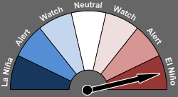
Super El Nino brewing?
You don't need a degree in climate studies to notice the flaming ribbon of orange and red developing in the tropical Pacific.

El Nino is here, and it's getting stronger. Some forecasters now think the eventual peak strength of this El Nino may challenge the record events of 82-83 and 97-98.
What would a very strong or "Super El Nino" event later this year mean?
In case you missed this week's Climate Cast on MPR News Stations, here's my conversation with Dr. Kevin Trenberth from the National Center for Atmospheric Research and Jason Samenow from The Washington Post's Capital Weather Gang. The excellent perspective from these guests is worth a listen.
Also, check out the latest update from the Australian Bureau of Meteorology here.

Study: Data doesn't support global temperature hiatus theory
A slowdown in global temperature rise? A "pause" in warming the past 15 years?
Nobody ever said planetary warming from climate change goes in a straight line. Some (attempt to) use a supposed pause as talking points that climate change is not happening. The warmest year on record (again) in 2014. Earth on pace (again) for another "warmest year on record" in 2015.
The thin thread for those who cling to the feeble "pause" notion has snapped now. This study from the journal Science confirms what serious, climate science based climate trackers already knew.
A new study published online today in the journal Science finds that the rate of global warming during the last 15 years has been as fast as or faster than that seen during the latter half of the 20th Century. The study refutes the notion that there has been a slowdown or "hiatus" in the rate of global warming in recent years.
The study is the work of a team of scientists from the National Oceanic and Atmospheric Administration's (NOAA) National Centers for Environmental Information* (NCEI) using the latest global surface temperature data.
"Adding in the last two years of global surface temperature data and other improvements in the quality of the observed record provide evidence that contradict the notion of a hiatus in recent global warming trends," said Thomas R. Karl, L.H.D., Director, NOAA's National Centers for Environmental Information. "Our new analysis suggests that the apparent hiatus may have been largely the result of limitations in past datasets, and that the rate of warming over the first 15 years of this century has, in fact, been as fast or faster than that seen over the last half of the 20th century."
