Excessive heat watch for metro area begins Sunday afternoon; hot on Monday too
Our dew points will be a bit sticky today, but they'll ramp up into the tropical 70s in many areas on Sunday. Our temperatures will be warmer on Sunday too.
The National Weather Service has issued an excessive heat watch for the Twin Cities metro area that begins Sunday afternoon and runs through Monday evening:
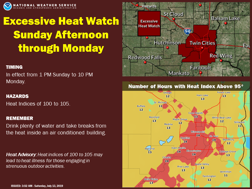
Details of the excessive heat watch:
Create a More Connected Minnesota
MPR News is your trusted resource for the news you need. With your support, MPR News brings accessible, courageous journalism and authentic conversation to everyone - free of paywalls and barriers. Your gift makes a difference.
URGENT - WEATHER MESSAGE
National Weather Service Twin Cities/Chanhassen MN
306 AM CDT Sat Jul 13 2019
MNZ060>063-068>070-131615-
/O.NEW.KMPX.EH.A.0002.190714T1800Z-190716T0300Z/
Hennepin-Anoka-Ramsey-Washington-Carver-Scott-Dakota-
Including the cities of Minneapolis, Blaine, St Paul, Stillwater,
Chaska, Shakopee, and Hastings
306 AM CDT Sat Jul 13 2019
...EXCESSIVE HEAT WATCH IN EFFECT FROM SUNDAY AFTERNOON THROUGH
MONDAY EVENING...
The National Weather Service in Twin Cities/Chanhassen has issued
an Excessive Heat Watch, which is in effect from Sunday afternoon
through Monday evening.
* TEMPERATURE...Highs in the lower 90s and dew points in the low
to mid 70s could make for heat indices around 100 Sunday and
between 100 and 105 Monday. Low temperatures Sunday night should
only fall into the mid 70s, providing little relief from the
heat.
* IMPACTS...The high heat indices during the day will lead to
increased risk for heat-related illness for those active
outdoors or with limited access to air conditioning.
PRECAUTIONARY/PREPAREDNESS ACTIONS...
An Excessive Heat Watch means that a prolonged period of hot
temperatures is expected. The combination of hot temperatures and
high humidity will combine to create a dangerous situation in
which heat illnesses are possible. Drink plenty of fluids...stay
in an air-conditioned room...stay out of the sun...and check up
on relatives and neighbors.
Temperature trends
Saturday afternoon highs will be mainly in the 80s across Minnesota and western Wisconsin, with some 70s along the North Shore of Lake Superior.
Sunday highs reach the lower 90s in much of the southern half of Minnesota and parts of Wisconsin:

Highs in the 90s linger in many areas on Monday:

Twin Cities metro area highs are projected to be around 90 on Tuesday and Thursday, with upper 80s Wednesday and lower 90s on Friday.
Rain and thunder chances
Southwestern and south-central Minnesota have the best chance of thunderstorms this Saturday, and some areas could see heavy rain. Portions of central Minnesota have seen scattered showers this morning.
As always, updated weather information can be heard on the Minnesota Public Radio Network, and you’ll also see updated weather info on the MPR News live weather blog.
You can see the recent local NWS radar loop here. The recent radar loop for southwestern Minnesota can be found here, and the southeastern Minnesota loop here.
The NWS Storm Prediction Center shows a marginal risk of severe weather this Saturday and Saturday night for portions of southwestern and south-central Minnesota:

Marginal risk means that an isolated severe thunderstorm is possible:
Parts of northern and central Minnesota have a slight risk of severe thunderstorms Sunday and Sunday night, with a marginal risk in the Twin Cities metro area:

The Twin Cities metro area could see an isolated Sunday morning shower/t-storm, but our main shower/t-storm chance in the metro appears to be later Sunday afternoon and Sunday evening. Check for updates.
Barry update
Tropical storm Barry had maximum sustained winds of 70 mph this Saturday morning, and was nearing the Louisiana coast. Barry is expected to reach hurricane strength before it makes landfall today along the Louisiana coast.
Double-digit rainfall totals are possible in portions of Louisiana and Mississippi:

The National Hurricane Center will post Barry updates every few hours this weekend.
Here's more on the flooding risk that Barry will bring to Louisiana and Mississippi:

_______________________________________________________________
1o a.m. Barry update
Barry is now a hurricane:
Here is Barry's projected track, along with the cone of uncertainty related to that track:

Details of Barry's impact:

_____________________________________________________________
Programming note
You can hear my live weather updates on Minnesota Public Radio at 7:49 a.m. Thursdays and Fridays, and at 7:35 a.m., 9:35 a.m. and 4:35 p.m. each Saturday and Sunday.