A quiet weekend; Canadian wildfire smoke lowers Ely air quality
It'll be nice to go through this Saturday afternoon without any severe weather warnings. And it'll be a comfy Saturday, with lowered dew points and near-normal highs.
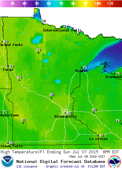
Temperature trends
Saturday afternoon highs will be mainly in the upper 70s to the lower 80s across Minnesota and western Wisconsin, but it’ll be cooler near Lake Superior. Most spots in the Twin Cities metro area will reach the lower 80s.
Sunday highs will be mainly in the lower 80s, with some 70s in northeastern Minnesota and parts of northwestern Wisconsin:
Create a More Connected Minnesota
MPR News is your trusted resource for the news you need. With your support, MPR News brings accessible, courageous journalism and authentic conversation to everyone - free of paywalls and barriers. Your gift makes a difference.
Twin Cities metro area highs are projected to be in the lower 80s Monday and Tuesday, around 80 Wednesday, then back to lower 80s Thursday and Friday. We don't see any really hot temps in the next week or so, but the European forecast model gives us a shot at 90 on July 14.
Unhealthy air quality in far northern Minnesota
Smoke from Canadian wildfires has lowered the air quality in Ely and other locations in far northern Minnesota:
The Minnesota Pollution Control Agency has updates on our Minnesota air quality. The meanings of various air quality values can be found here.
______________________________________________________________________
Mid afternoon update
The MPCA has issued an air quality alert that will remain in effect until noon on Sunday for the northern third of Minnesota:
______________________________________________________________________
Rain chances
Far southeastern Minnesota could see some scattered light rain showers this Saturday morning, but dry weather is expected today across most of Minnesota and western Wisconsin. An isolated late afternoon shower will be possible in southern Minnesota and the Twin Cities metro area.
On Sunday, western Minnesota could see some scattered showers/isolated thunderstorms in the late afternoon and early evening.
We'll have some periods of showers and thunderstorms from Tuesday into Wednesday. The National Oceanic and Atmospheric Administration’s Global Forecast System model shows the potential rain pattern from Tuesday through Wednesday:

The color chart to the right of the loop refers to the precipitation rate (mm per hour), not to the total amount of rain. It’ll rain in some areas that look dry in the GFS model, but the loop shows the general rain pattern. Check forecast updates.
As always, updated weather information can be heard on the Minnesota Public Radio Network, and you’ll also see updated weather info on the MPR News live weather blog.
Friday tornado sightings
There were at least three tornado sightings in southern Minnesota on Friday. There were two reports of tornado touchdowns in Sibley county between 5:37 and 5:45 p.m. on Friday, one near Arlington and one near Henderson. A roof was peeled off a building in Arlington by Friday’s storms. A NWS storm survey will determine if that was caused by a tornado or straight line winds. Later, around 7:45 pm Friday, multiple spotters reported a 5- to- 10-second duration tornado touchdown in a grove of trees near Elysian, in Le Sueur county.
This is video of the Friday tornado touchdown near Henderson, in Sibley county:
This is some Friday storm damage in Arlington, Minn., which is also in Sibley county:
Here are the tornado-related reports from Friday, via the Twin Cities office of the National Weather Service:


Thunderstorms also dropped several inches of rain in some parts of southern Minnesota Friday evening, which lead to areas of flash flooding.
It'll be nice to have a couple of days to dry out.
Programming note
You can hear my live weather updates on Minnesota Public Radio at 7:49 a.m. Thursdays and Fridays, and at 7:35 a.m., 9:35 a.m. and 4:35 p.m. each Saturday and Sunday.