Wednesday night, Thursday thunder chances; temps, humidity ramp up
We sometimes dream about summery warmth during the coldest days of winter. That warmth is sometimes accompanied by very humid air, which will be the case from Friday through the weekend.
On to the details.
Temperature trends
Most of Minnesota and western Wisconsin will see Wednesday afternoon highs in the 80s, with a few upper 70s in northeastern Minnesota. Some spots in the Twin Cities metro area could reach the mid-80s. Our average high temp is 82 degrees this time of year in the Twin Cities.
Create a More Connected Minnesota
MPR News is your trusted resource for the news you need. With your support, MPR News brings accessible, courageous journalism and authentic conversation to everyone - free of paywalls and barriers. Your gift makes a difference.
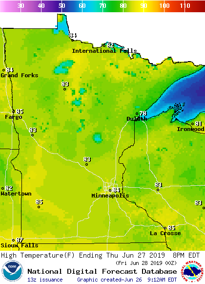
Thursday highs will also be mainly in the 80s:
Dew points will rise well into the sticky 60s Thursday afternoon in central and southern Minnesota plus western Wisconsin. That sticky air will linger through Friday.
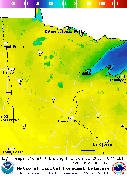
Friday highs will hit 90 degrees or higher in parts of southern Minnesota:
Our weekend will be steamy. Dew points in central and southern Minnesota plus western Wisconsin are expected to reach the lower 70s. Highs will reach the 90s in those same areas, with afternoon heat index values of 100 or higher possible. You'll want to stay hydrated this weekend.
After highs around 90 Friday and in the low to mid 90s this weekend, Twin Cities metro area highs retreat to the 80s next Monday and Tuesday.
Rain and thunder chances
The Wednesday morning showers in southwestern Minnesota are expected to gradually break up as they spread to the east-southeast.
We could see scattered showers and thunderstorms move into southern and central Minnesota Wednesday evening. Those same areas plus western Wisconsin will have a good chance of showers and thunderstorms at times overnight and Thursday morning. Scattered showers and thunderstorms will also be possible Thursday afternoon and evening.
The National Oceanic and Atmospheric Administration’s High-Resolution Rapid Refresh (HRRR) model shows this potential rain pattern Wednesday evening through 4 p.m. Thursday:

The color chart to the right of the loop refers to the strength of the signal that returns to the radar, not to the amount of rain. It will rain in some areas that look dry in the HRRR loop, but the loop shows the general rain pattern within the model.
As always, updated weather information can be heard on the Minnesota Public Radio Network, and you’ll also see updated weather info on the MPR News live weather blog.
You can see the recent local National Weather Service radar loop here. The recent radar loop for southwestern Minnesota can be found here, and the southeastern Minnesota loop here.
Severe weather
Some severe weather is possible Wednesday night and Thursday:
The severe weather potential in the Twin Cities metro area will begin while we are sleeping, so this would be a good night to have a NOAA weather radio nearby or a phone app that will wake you up if there is a severe weather warning.
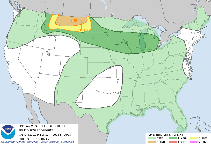
In their latest update, the Storm Prediction Center of the National Weather Service trimmed the southeast corner of the slight risk area slightly. This new outlook covers Wednesday through 7 a.m. Thursday:

Slight risk means that scattered severe thunderstorms are possible:
SPC shows a marginal risk of weather for about the southern half of Minnesota during the period from 7 a.m. Thursday through Thursday night:
The SPC will update there severe weather outlooks several times over the next 24 hours.
European heat wave
Do you know anyone who is vacationing in Europe right now? It's very hot there: