Warmer temps this week; frosty start Monday in northern Minnesota
Average temps are more than OK in June.
Our average high temp is 74 degrees this time of year in the Twin Cities metro area. The Sunday high of 75 degrees at Minneapolis-St. Paul International Airport followed a Saturday high of 73 degrees. Average those weekend highs and you get 74 degrees.
Most of Minnesota and western Wisconsin enjoyed pleasant afternoon temps, dry weather and plenty of sunshine this weekend. The only daytime showers of note were the Saturday morning showers in south-central and southeastern Minnesota and southwestern Wisconsin.
If you like warmer temps, you won't have to wait very long.
Create a More Connected Minnesota
MPR News is your trusted resource for the news you need. With your support, MPR News brings accessible, courageous journalism and authentic conversation to everyone - free of paywalls and barriers. Your gift makes a difference.
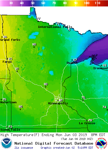
Temperature trends
International Falls and Hibbing had record low temperatures Sunday morning:
It'll be cold again late Sunday night into Monday morning in north-central and northeastern Minnesota, with a lot of lows in the 30s. Some 20s are also possible.
The National Weather Service has issued a freeze warning for Lake and Cook counties of northeastern Minnesota from 11 p.m. Sunday to 8 a.m. Monday. A frost advisory for the same period covers much of St. Louis county (but not Duluth) plus north-central Minnesota:

Central and southern Minnesota will have milder low temps, in the 40s to lower 50s.
High temps Monday afternoon will be close to 80 degrees across much of Minnesota, with cooler highs in northeastern Minnesota and western Wisconsin:
Twin Cities metro area highs are projected to reach the mid 80s on Tuesday, followed by lower 80s Wednesday through Friday.
Rain chances
Southwestern Minnesota could see scattered showers and an isolated thunderstorm late Monday afternoon and Monday evening. Our shower/t-storm chance is expected to hold off until after midnight on Monday in the Twin Cities metro area.
As always, updated weather information can be heard on the Minnesota Public Radio Network, and you’ll also see updated weather info on the MPR News live weather blog.
Minnesota and western Wisconsin could see some scattered showers and thunderstorms at times on Tuesday and Tuesday night. The National Oceanic and Atmospheric Administration’s Global Forecast System model shows the potential precipitation pattern from Monday evening through Wednesday morning:

Minnesota and western Wisconsin could see a few strong to severe thunderstorms late Tuesday afternoon into Tuesday night. The Storm Prediction Center of the National Weather Service shows a marginal risk of severe weather Tuesday and Tuesday night in Minnesota and western Wisconsin:

Marginal risk means that an isolated severe thunderstorm is possible. The SPC outlook for Tuesday will be updated Monday morning.
I hope that you have a good week.