Very summery through Saturday; cooler on Sunday
How wet has it been the past 12 months? The United States had its wettest June (2018) through May (2019) period, while Minnesota recorded its second-wettest June through May:
Precipitation includes rainfall plus the water content of snow.
We could see some additional rain later this weekend.
Temperature trends
Create a More Connected Minnesota
MPR News is your trusted resource for the news you need. With your support, MPR News brings accessible, courageous journalism and authentic conversation to everyone - free of paywalls and barriers. Your gift makes a difference.
Our Friday will feel very summery. Friday afternoon highs are expected to pop into the 90s in parts of far western Minnesota. The rest of Minnesota plus western Wisconsin will see mostly 80s, but it'll be cooler near Lake Superior, with highs in the 60s and 70s. Most of the Twin Cities metro area will top out in the upper 80s, with a few spots touching 90. Our average high temp is 76 degrees this time of year in the Twin Cities metro area.
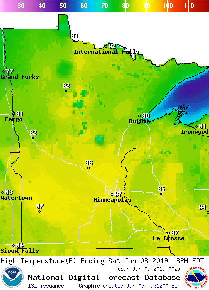
Most of us will have highs in the 80s on Saturday:
Sunday highs will be cooler:

Twin Cities metro area highs are projected to reach the mid 70s Monday and Tuesday, followed by around 70 Wednesday and lower 70s Thursday.
Windy northwest
A wind advisory runs from noon to 7 p.m. Friday for three counties in northwestern Minnesota:

Winds of about 30 mph, with gusts to 45 mph, are expected. You can check for updates on the winds here.
Rain and thunder chances
Far northwestern Minnesota will have a shower and thunderstorm chance Friday night. Northwestern and west-central Minnesota will have an increasing chance of showers and thunderstorms Saturday afternoon, with the rain area expanding eastward Saturday evening and overnight Saturday night. Eastern Minnesota (including the Twin Cities) and western Wisconsin will have a chance of occasional showers and thunderstorms late Saturday night and Sunday morning.
The National Oceanic and Atmospheric Administration's North American Mesoscale forecast model shows the potential rain pattern Saturday through Sunday afternoon:

The color chart to the right of the loop refers to the strength of the signal that returns to the radar, not to the amount of rain.
It will rain in some areas that look dry in the simulated radar loop, but the loop illustrates the general rain pattern.
As always, updated weather information can be heard on the Minnesota Public Radio Network, and you’ll also see updated weather info on the MPR News live weather blog.
Severe weather outlook
The Storm Prediction Center of the National Weather Service shows a marginal risk of severe weather Saturday and Saturday night in much of western Minnesota:

Marginal risk means that an isolated severe thunderstorm is possible. The Saturday and Saturday night severe weather outlook will be updated by the SPC Friday afternoon.
Programming note
You can hear my live weather updates on Minnesota Public Radio at 7:49 a.m. Thursdays and Fridays, and at 7:35 a.m., 9:35 a.m. and 4:35 p.m. each Saturday and Sunday.