A string of 70s ahead; shower and thunder chances peak later in the week
It was a pleasant Sunday across most of Minnesota and western Wisconsin. A few spots saw some raindrops at times. We'll have some nice weather through much of this week, with thunder chances increasing in a few days.
Temperature trends
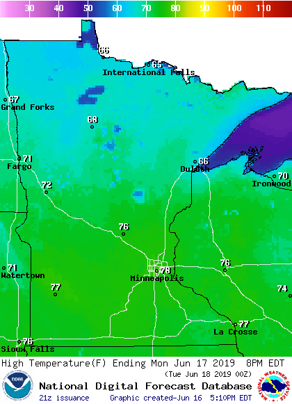
Monday highs will be in the 70s across most of Minnesota and western Wisconsin, with 60s in far northern Minnesota:
Upper 70s won't be too far from our average June 17 high temp of 80 degrees in the Twin Cities.
Create a More Connected Minnesota
MPR News is your trusted resource for the news you need. With your support, MPR News brings accessible, courageous journalism and authentic conversation to everyone - free of paywalls and barriers. Your gift makes a difference.
Most areas will see highs in the 70s on Tuesday:

Twin Cities metro area highs are projected to reach the mid 70s Wednesday and Thursday, followed by upper 70s Friday.
Rain and thunder chances
The best chance of scattered showers and thunderstorms Sunday evening will be in roughly the northern half of Minnesota, but a few very scattered showers and thunderstorms could move through portions of the southern half of Minnesota too.
As always, updated weather information can be heard on the Minnesota Public Radio Network, and you’ll also see updated weather info on the MPR News live weather blog.
On Monday some scattered showers and an isolated thunderstorm will be possible in Minnesota and western Wisconsin, but must of the day will be dry. The shower/isolated t-storm chance in the Twin Cities metro area will tend to be toward the late afternoon and evening.
Tuesday is looking mostly dry, then a shower t-storm chance returns late Wednesday. NOAA’s Global Forecast System model shows this potential precipitation pattern for Thursday and Friday:

The timing and intensity of the rain could change in the forecast models as we go through the week, so don’t alter any Thursday or Friday plans.
Minnesota's last EF-5 tornado
According to the National Weather Service, Sunday was the anniversary date of Minnesota's last EF-5 tornado:
The NWS summary of the Chandler-Lake Wilson tornado states:
June 16, 1992 marks the day a devastating tornado ravaged portions of southwest Minnesota. Commonly referred as the Chandler-Lake Wilson tornado, this tornado destroyed more than 75 homes with another 90 homes, 10 businesses, a church and school damaged. The tornado caused over $50 million in property damage, resulting in more than 40 injuries and one fatality. Based on a detailed damage assessment by the National Weather Service, it is estimated this F5 tornado packed winds in excess of 260 mph as it tore through the residential area of Chandler Minnesota. This was the only F5 tornado to occur in the United States in 1992.
Our Minnesota severe weather season is typically most active from late May through June and much of July:
I hope that you have a good week!