Windy with cold rain today; snowflake chances to the northeast
Aren't you glad that Mother's Day isn't this Sunday? Moms enjoyed much better weather one week ago!
It'll be windy and cold today, with rain lingering into the afternoon in most areas. Some of us will see some sleet and snowflakes too. On to the details.
Rain and snow
Much of northwestern Minnesota and parts of north-central Minnesota will have a dry Sunday. The rest of us will have rain this Sunday morning and into this afternoon. The rain tapers off from west to east in central and southern Minnesota later this afternoon. There could be a rain/snow mix at times today along and east of line from around Hinckley to Duluth and into northwestern Wisconsin. Some spots could see some minor accumulations on grassy areas and there could be a bit of sleet at times too. The higher elevations near the North Shore might also see some flakes.
Create a More Connected Minnesota
MPR News is your trusted resource for the news you need. With your support, MPR News brings accessible, courageous journalism and authentic conversation to everyone - free of paywalls and barriers. Your gift makes a difference.
The National Oceanic and Atmospheric Administration’s North American Mesoscale forecast model shows the potential precipitation pattern from Sunday through Sunday evening:

The color chart to the right of the loop refers to the strength of the signal that returns to the radar, not to the amount of rain or snow.
As always, updated weather information can be heard on the Minnesota Public Radio Network, and you’ll also see updated weather info on the MPR News live weather blog.
You can check for forecast updates from the National Weather Service offices in Duluth, the Twin Cities,
Here’s a NWS summary of the likeliest areas to see some flakes today:
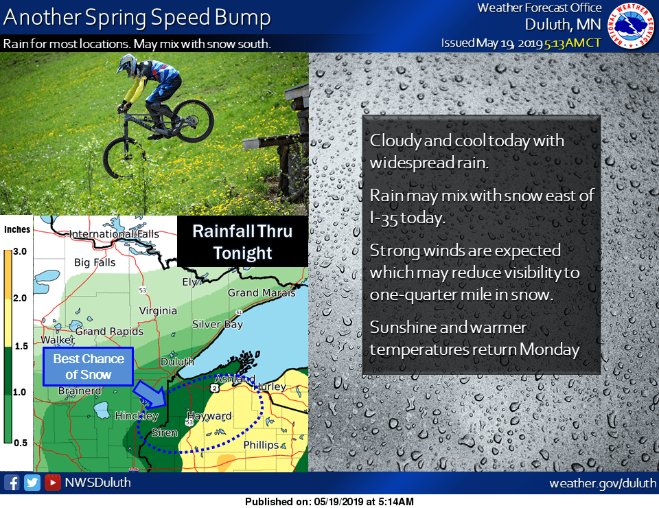
I should also mention that there are gale warnings in effect for Lake Superior today.
____________________________________________________________________________
Morning update:
The NWS has issued a wind advisory for portions of northeastern Minnesota and northwestern Wisconsin that runs until 3 p.m.:

Winds could gust as high as 40 to 50 mph at times in the advisory area.
And there's this:
___________________________________________________________________________
___________________________________________________________________________
11 a.m. update
The NWS Duluth office has issued a winter weather advisory from now until 1 a.m. Monday for parts of northeastern Minnesota and northwestern Wisconsin:

Here are details of the advisory:
URGENT - WINTER WEATHER MESSAGE
National Weather Service Duluth MN
1040 AM CDT Sun May 19 2019
...ACCUMULATING SNOWFALL ACROSS PARTS OF THE NORTHLAND...
.Snowfall has started accumulating and will continue to
accumulate into this evening. The highest accumulation will be
mainly along the Highway 2 Corridor and across higher elevations
in northwest Wisconsin. Locations immediately adjacent to Lake
Superior should remain too warm to see any accumulation.
Accumulating snowfall on trees combined with strong winds may
cause power outages due to fallen branches.
MNZ037-038-200345-
/O.NEW.KDLH.WW.Y.0024.190519T1540Z-190520T0600Z/
Carlton and South St. Louis-Pine-
Including the cities of Duluth, Pine City, and Hinckley
1040 AM CDT Sun May 19 2019
...WINTER WEATHER ADVISORY IN EFFECT UNTIL 1 AM CDT MONDAY...
* WHAT...Wet snow. Additional snow accumulations of up to 3
inches. Winds gusting as high as 40 to 50 mph.
* WHERE...Carlton and South St. Louis and Pine Counties. This
includes the Tribal Lands of the Mille Lacs Band Lena Lake and
Hinckley areas.
* WHEN...Until 1 AM CDT Monday.
* ADDITIONAL DETAILS...Plan on slippery road conditions.
PRECAUTIONARY/PREPAREDNESS ACTIONS...
A Winter Weather Advisory for snow means periods of snow will
cause primarily travel difficulties. Expect snow covered roads
and limited visibilities, and use caution while driving.
The latest road conditions for Minnesota can be found at
511mn.org, and for Wisconsin at 511wi.gov, or by calling 511 in
either state.
__________________________________________________________________________
Temperature trends/frost advisory
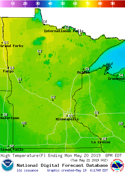
Minnesota and western Wisconsin highs will be mainly in the 40s today, with some 50s in northwestern Minnesota and parts of north-central Minnesota. This feels more like March than May. Our average high temp is 70 degrees this time of year in the Twin Cities metro area.
Winds lighten overnight Sunday night and our clouds will thin out, dropping low temperatures into the 30s early Monday:

Frost advisories have been issued for much of Minnesota and parts of western Wisconsin from 1 a.m. to 8 a.m. Monday:

The frost advisory includes the Twin Cities metro area. Traverse and Big Stone counties of west-central Minnesota will be in a freeze warning from 1 a.m. to 9 a.m. Monday.
Highs recover nicely Monday afternoon, reaching the lower 60s in many areas:
rain potential
Twin Cities metro area highs are projected to be around 60 degrees on Tuesday, followed by lower 70s Wednesday. We could reach the mid to upper 70s Thursday and Friday.
Programming note
You can hear my live weather updates on Minnesota Public Radio at 7:49 a.m. Thursdays and Fridays, and at 7:35 a.m., 9:35 a.m. and 4:35 p.m. each Saturday and Sunday.