Warming trend; Saturday will be the nicer day of the weekend
The high temperature at Minneapolis-St. Paul International Airport reached 57 degrees on Thursday. That was quite an improvement over our 40s of Tuesday and Wednesday.
We'll continue that upward temperature trend, with Friday afternoon highs in the 60s in the Twin Cities metro area and much of central and southern Minnesota. The northern third of Minnesota will see mostly 50s, although it will be a bit cooler than that near Lake Superior. Our average high temp is 66 degrees this time of year in the Twin Cities metro area.
Saturday highs reach the lower 70s across most of southern Minnesota:
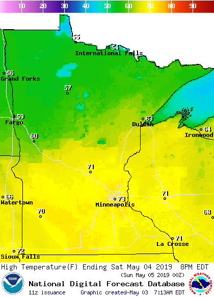
Northern Minnesota will see 50s and 60s.
Create a More Connected Minnesota
MPR News is your trusted resource for the news you need. With your support, MPR News brings accessible, courageous journalism and authentic conversation to everyone - free of paywalls and barriers. Your gift makes a difference.
High temps in the south retreat a bit on Sunday:

Twin Cities metro area highs are projected to be in the lower 60s next Monday through Thursday.
Rain chances
Scattered showers in western Minnesota Friday morning will spread slowly eastward through the day. There could also be an isolated thunderstorm. The Twin Cities metro area could see a late afternoon shower, with a chance of scattered showers and an isolated thunderstorm Friday evening and overnight Friday night.
Scattered showers/isolated thunderstorms favor northern Minnesota Saturday afternoon, with that shower/thunderstorm chance spreading into southern Minnesota and the Twin Cities metro area Saturday night. Occasional showers are possible in central and southern Minnesota on Sunday.
The National Oceanic and Atmospheric Administration's North American Mesoscale forecast model shows the potential rain pattern Saturday through Sunday morning:

The color chart to the right of the loop refers to the strength of the signal that returns to the radar, not to the amount of rain.
As always, updated weather information can be heard on the Minnesota Public Radio Network, and you’ll also see updated weather info on the MPR News live weather blog.
Tropical Cyclone Fani
What we call hurricanes are called tropical cyclones in the Indian Ocean. Tropical Cyclone Fani made landfall along India's east coast Friday morning, accompanied by the strongest winds that that area has seen in 20 years:
More info can be found at #FaniCyclone
Programming note
You can hear my live weather updates on Minnesota Public Radio at 7:49 a.m. Thursdays and Fridays, and at 7:35 a.m., 9:35 a.m. and 4:35 p.m. each Saturday and Sunday.