Peak Minnesota: Volatile weather pattern ahead
Welcome to Minnesota. Some translate the meaning of the word Minnesota as "sky-tinted water." These days it could easily be called, "Land of Extreme Weather Volatility."
Get ready for a wild weather ride over the next few days.
Peak Minnesota
One look at forecast temperatures over the next week tells a lot about our volatile weather. The season's first 80-degree temperature blows into many southern Minnesota towns Thursday afternoon. Minnesota rides the boundary between summer, and a chilly spring hangover Thursday.
Create a More Connected Minnesota
MPR News is your trusted resource for the news you need. With your support, MPR News brings accessible, courageous journalism and authentic conversation to everyone - free of paywalls and barriers. Your gift makes a difference.

By Saturday morning it feels 30 degrees colder in southern Minnesota. We stagger back into the 70s late next week.

Wet pattern evolving
Last night's spotty thundershowers were a preview of coming attractions. Scattered storms rumble across northern Minnesota overnight. Thursday morning features spotty storms in and around the Twin Cities area. Don't be surprised to wake to a clap of thunder or local downpour Thursday morning.
NOAA's HRRR model paints a broken line of thundershowers moving southeast across Minnesota overnight. This model projects rain and possible thunder into the Twin Cities between about 3 and 5 am. Other models are a little slower. Here's the HRRR.

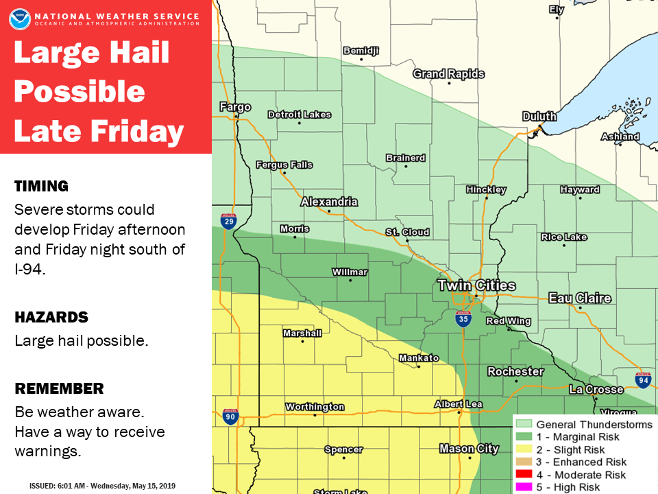
Friday severe risk?
Our next series of low-pressure waves push in this weekend. The first one could trigger a few severe storms favoring southwest Minnesota late Friday.
Weekend washout
I wish I could change the timing on Minnesota's weekend weather forecast. I've been kicking and rebooting the Doppler, to no avail.
A strong low-pressure system slams into Minnesota this weekend. It may not rain all the time, but washout seems like the best word to describe the frequent rainy bouts this weekend. The Canadian and European models are among the most aggressive with rainfall coverage and intensity this weekend. Details may vary, but it's going to rain this weekend.
Here's the Canadian.

The European model concurs. Loudly.

Multi-inch rainfall
Forecast models still crank out multi-inch rainfall totals this weekend. The higher-end solutions suggest widespread 2" to 4" totals, with locally heavier amounts favoring southern Minnesota. The Canadian model cranks out nearly 7 inches of rain in southern Minnesota this weekend. I'm concerned about possible flood warnings in southern Minnesota. Farmers with soggy fields could use a break.

Naturally, Monday looks nice. More rain may arrive by next Wednesday. It appears flooding will be a theme for the next couple of weeks.
Stay tuned.