Weekend April showers; first 70 Monday? Rain, snow chances next week?
The weather maps look "interesting" in the next week.
We begin with an April warm front. Scattered showers and a few thundershowers bubble up this weekend as a warm front pushes north through Minnesota.
The National Oceanic and Atmospheric Administration's NAM 3 km model gives you the idea as shower clusters with embedded thundershowers ride northeast through Sunday.
It won't rain all the time, but we'll see several hours of rain this weekend.
Create a More Connected Minnesota
MPR News is your trusted resource for the news you need. With your support, MPR News brings accessible, courageous journalism and authentic conversation to everyone - free of paywalls and barriers. Your gift makes a difference.

Weekend soaker
Rainfall totals this weekend will add up. Widespread one-half inch totals look likely.
Locations that pick up local downpours in thundershowers could top out around an inch this weekend. We're into the convective rain season now. Precipitation totals can be highly variable over short distances this weekend.

Temperatures: sunshine dependent
Cloud cover is critical this time of year for temperatures. Areas that stay cloudy will hover in the 40s and 50s this weekend. But the air mass is warm enough that if the sun pops out for a couple hours, temps will spike into the 60s.
Monday looks like the sunniest, warmest day. Many models suggest a shot at the season's first 70-degree temperature in the Twin Cities Monday.

Here are the numbers for Duluth and much of northern Minnesota. About 10 degrees cooler "up north."

Rain or snow chances next week?
The latest model runs still crank up a storm in the Upper Midwest next week. There are southward storm track shifts today in the American and Canadian models.
The National Oceanic and Atmospheric Administration's Global Forecast System model still suggest a significant snow event but tracks the storm mostly through Iowa.

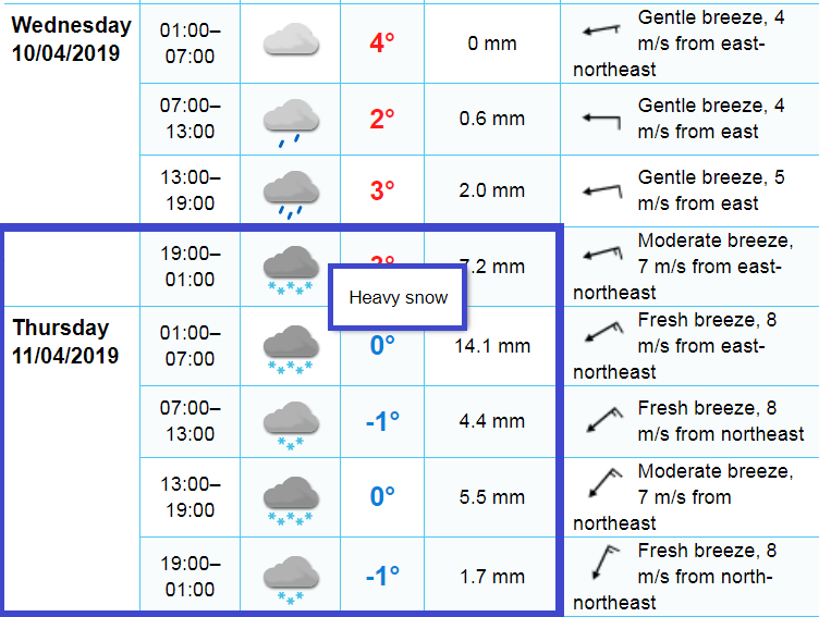
The European Centre for Medium-Range Weather Forecasts model still cranks out potentially heavy snow for the Twin Cities area Wednesday night and Thursday.
It's still too early to bet on any one solution here. But we'll need to watch these trends as we move into next week.
Red River Rising
The flood story has shifted to the Red River. The river is rising rapidly now at Fargo and is expected to crest near 35 feet this weekend.

Stay tuned.