Wednesday rain and thunder, a shot at 70 Saturday?
"Spring is nature's way of saying, Let's party!" - Robin Williams
Robin Williams' wonderful springtime quote surely fits how many Minnesotans feel after our rigorous winters. It's true we earn our summers in Minnesota.
Spring is the promise that summer keeps.
Create a More Connected Minnesota
MPR News is your trusted resource for the news you need. With your support, MPR News brings accessible, courageous journalism and authentic conversation to everyone - free of paywalls and barriers. Your gift makes a difference.
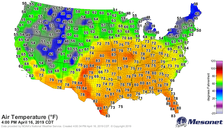
60s surge north
I saw 60s all the way to the Canadian border Tuesday afternoon. Warmer, springlike air masses are now building in the central Plains. Highs in the 70s now frequently ride as far north as Iowa. Highs in the 80s lurk further south. Spring is coming folks. Baby steps.
Rainy Wednesday
Rain moves into Minnesota from the south early Wednesday morning. Scattered thunderstorms pop up in the midday and afternoon hours. A few of the cells will be strong enough to drive locally heavy downpours, gusty winds, and small hail. A few storms could approach severe limits in southeast Minnesota and western Wisconsin late Wednesday afternoon into the evening.
The National Oceanic and Atmospheric Administration's NAM 3 km resolution model captures the essence.

NOAA's Storm Prediction Center pushes a marginal risk for severe weather into southeast Minnesota and Wisconsin. Hail and high winds are the primary threats. A bigger outbreak looks likely for the southern Plains.

Overall rainfall totals still favor widespread one-half to 1-inch amounts. Locally 1-plus inches will fall under the heavier cells.

A shot at 70 Saturday?
Sunshine and milder temperatures return by Friday afternoon. Saturday should be the warmest of the next week. Highs could reach 70 degrees in the Twin Cities and across most of western half of Minnesota.

At last, spring.