Rain and thunder Wednesday, 70 by Saturday
Rainy thunder clusters. It could be a mad weatherperson's breakfast cereal. In our current context, it's what I'm seeing on Doppler Wednesday.
Expect roving bands of scattered rain and thunderstorms. A few of the storms could get feisty with lightning strikes, local downpours, small hail and gusty winds. Most of northern Minnesota soaks in just plain rain.
The National Oceanic and Atmospheric Administration's NAM 3 km resolution model captures the essence of thunderstorm clusters Wednesday, and lingering showers band Thursday.

Severe risk south
Create a More Connected Minnesota
MPR News is your trusted resource for the news you need. With your support, MPR News brings accessible, courageous journalism and authentic conversation to everyone - free of paywalls and barriers. Your gift makes a difference.
NOAA's Storm Prediction Center doesn't see any severe risk in the Twin Cities area, but a marginal risk in far southeast Minnesota means a few storms could approach or reach severe limits.

Widespread one-half inch to 1-inch rainfall totals still look likely. Locally, over an inch will fall in areas that see multiple storm clusters pass overhead.

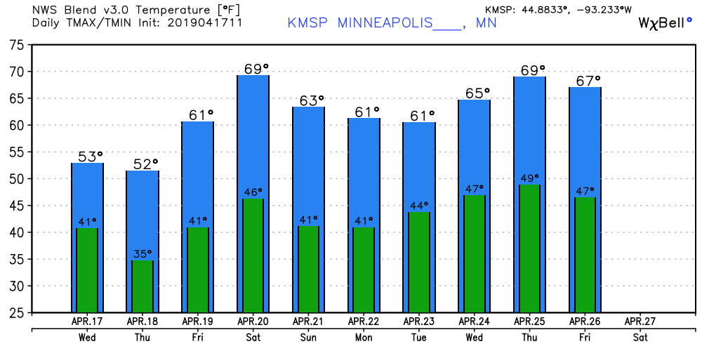
70s ahead
The weather pattern shifts for the warmer over the next two weeks. The jet stream pattern looks more May than April by as early as this weekend. And the overnight model runs appear ready to shove significantly warmer air into the Upper Midwest by early May.

Forecast models push temperatures near or above 70 degrees into western Minnesota, and possibly the Twin Cities Saturday. May-like warmth returns again late next week. My hunch is the numbers below could be a few degrees too conservative.
The overnight European and American models suggest highs in the upper 70s -- even 80 degrees -- look plausible in the next two weeks.

Time to get the window screens and the boat in.