Late May warmth today! ; river levels are rising
Our average high temp is 60 degrees this time of year in the Twin Cities metro area. We'll be poking into the 70s this Saturday afternoon, possibly reaching the mid 70s. Our average Twin Cities high temp is 74 degrees on the final two days in May.
Temperature trends
Highs in 70s are expected across about the southern two-thirds of Minnesota Saturday afternoon. A few spots in west-central and southwestern Minnesota could touch 80. Highs in the 60s are on tap for most of the northern third of Minnesota.
Sunday high temperatures will depend on the progress of a cold front that will be sagging southward during the day. The National Oceanic and Atmospheric Administration's North American Mesoscale forecast model shows temps early Sunday afternoon ranging from 40s and 50s in northern Minnesota to 70s in the far south:
Create a More Connected Minnesota
MPR News is your trusted resource for the news you need. With your support, MPR News brings accessible, courageous journalism and authentic conversation to everyone - free of paywalls and barriers. Your gift makes a difference.

We'll have a Sunday forecast update later today.
Twin Cities metro area highs are projected to reach the lower 50s Monday, followed by around 60 on Tuesday and low to mid 60s Wednesday through Friday.
Rain chances
The northern third of Minnesota will have the best chance of scattered showers and an isolated thunderstorm this Saturday afternoon and evening. That rain chance spreads into central Minnesota and the Twin Cities metro area overnight and early Sunday, with scattered showers and a few thunderstorms also possible later Sunday.
On Monday, the southern half of Minnesota has the best chance of showers and there could be a few embedded thunderstorms.
The National Oceanic and Atmospheric Administration's North American Mesoscale forecast model shows the potential rain pattern Saturday evening through Monday afternoon:

As always, updated weather information can be heard on the Minnesota Public Radio Network, and you’ll also see updated weather info on the MPR News live weather blog.
River level update
Wednesday's rains have caused many river levels to rise around Minnesota. There are numerous flood warnings in effect. You can get flood warning updates by clicking on any location on the National Weather Service Twin Cities website. Areas with flood warnings are shaded green on the NWS main page; here’s how the map looked Saturday morning:

The latest flood warnings for northwestern Minnesota can be found on the NWS Grand Forks, N.D. site. Here’s how their map looked Saturday morning:

You can click on any location on the NWS Advanced Hydrologic Prediction Service (AHPS) site to get hydrographs of recent and forecast river levels. Some locations list levels in feet above sea level, others list levels in feet above a local reference point.
Here’s the Saturday morning hydrograph for the Mississippi River at St. Paul:
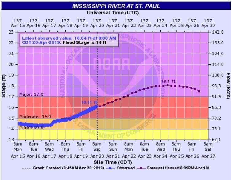
You can see that the Mississippi River at St. Paul is expected to crest on Wednesday. It'll be well short of its crest on March 31, 2019, which was the seventh-highest on record:

Here’s the Saturday morning hydrograph for the St. Croix River at Stillwater:

Projected river levels are updated on a regular basis, so check back to the AHPS site and the NWS point forecasts for the latest info on the rivers near you. The NWS also posts some flooding details here.
If you’d like to scroll through hydrographs along a certain river, check here.
Hydrographs for the Red River can be found here. The Saturday morning hydrograph for the Red River at Fargo, North Dakota looked like this:

Here’s the Saturday morning hydrograph for the Red River at East Grand Forks, Minnesota:

Programming note
You can hear my live weather updates on Minnesota Public Radio at 7:49 a.m. Thursdays and Fridays, and at 7:35 a.m., 9:35 a.m. and 4:35 p.m. each Saturday and Sunday.