Best snow chances Saturday stay south of Twin Cities
Saturday's late April storm system is still on track to bring a mixed bag of rain and snow to southern Minnesota. But there are huge model differences on how much, if any, snow will accumulate in the Twin Cities.
My read of this inbound system remains the same as a few days ago. Conditions favor mostly rain for the Twin Cities with a few snowflakes mixed in, and little or no snowfall accumulation for most of the Twin Cities.
The system:
This low-pressure system tracks from Nebraska through Iowa Saturday. It will get stronger as it moves east. I'm inclined to agree with the Canadian model's interpretation. A mix of rain and snow across southern Minnesota with the best chance for accumulating snow staying south of the Twin Cities.
Create a More Connected Minnesota
MPR News is your trusted resource for the news you need. With your support, MPR News brings accessible, courageous journalism and authentic conversation to everyone - free of paywalls and barriers. Your gift makes a difference.
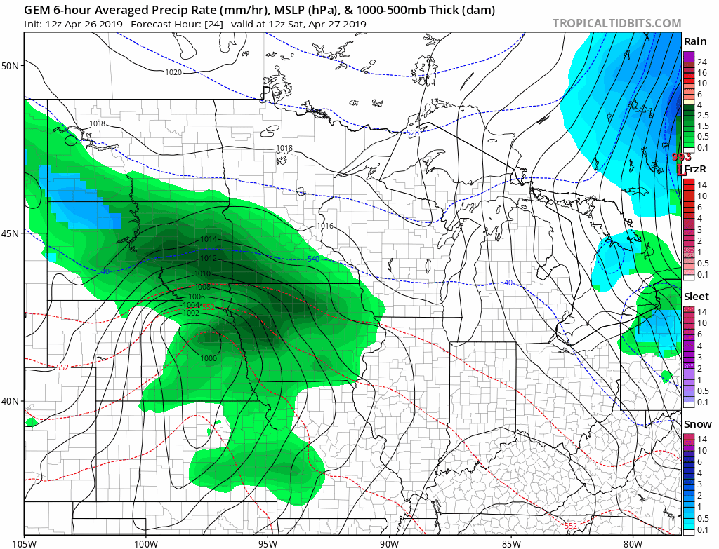
Major model spread
It's interesting, and a little frustrating, to see such a big model spread with this system. The European and Canadian models, along with the National Oceanic and Atmospheric Administration's Global Forecast System model, agree with a mostly rain scenario for the Twin Cities.
The last several runs from NOAA's North American Mesoscale Forecast System model have been hitting the notion of significant snowfall for the Twin Cities hard. But the NAM is the outlier. And it's shifting south.
Here's Friday morning's 12z NAM 3 km model for 9 am Saturday. See how it brings heavy snow right up to the Twin Cities?

Now, look at the latest Friday afternoon 18z run. See the shift south, keeping most of the snow south of the Twin Cities?

That's yet another trend line that suggests little if any snowfall accumulation for the Twin Cities.
Euro: All rain
Like the GFS and Canadian models, the usually trusty European Centre for Medium-Range Weather Forecasts model suggests mostly rain for the Twin Cities Saturday.

Southern Minnesota: A few slushy inches
The best chance for accumulating snow to my eye lays out across southern Minnesota, northeast Iowa, and southern Wisconsin.
I still think the NAM model solutions are overdone on snowfall. And indeed the latest NAM run has dialed back. A couple to a few slushy inches are likely across most of southern Minnesota. The best chance for significant snow runs from Rochester, Minn., and Decorah, Iowa, through Madison, Janesville, Milwaukee in Wisconsin and the northern suburbs of Chicago.

This is one of those rare occasions when I don't sync with current National Weather Service advisories. I have an honestly different interpretation of the forecast from the amazing staff at our local NWS office.
I may be scraping egg off my face on this, but I think the advisories for the southern Twin Cities are overdone. And to my eye, much of southern Minnesota may not reach winter storm warning criteria.
I won't be surprised to see the current coverage of advisories dialed back by Saturday morning.

I'll keep the egg scraper handy just in case.
Milder next week
Our weather stays cool into early next week. But temperatures rebound again through the 60s late next week.

Spring resumes next week.