A cool but quiet Sunday; stuck in the 50s
Residents of far southern Minnesota, who saw wet snow on Saturday, can look forward to much better weather on Sunday. Northwestern Minnesota had plenty of Saturday sunshine, but Sunday will bring clouds and a shower chance to that area.
April is known for its changeable weather.
Temperature trends
Sunday highs will be in the upper 40s to lower 50s across most of Minnesota and western Wisconsin;
Create a More Connected Minnesota
MPR News is your trusted resource for the news you need. With your support, MPR News brings accessible, courageous journalism and authentic conversation to everyone - free of paywalls and barriers. Your gift makes a difference.
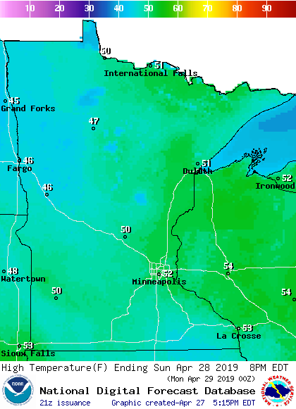
That's cool for late April; our average high temp is 64 degrees this time of year in the Twin Cities metro area.
Monday highs will reach the 40s north, with mainly lower 50s south:

to
Twin Cities metro area highs are projected to reach the lower 50s Tuesday and Wednesday, followed by mid 50s Thursday and upper 50s Friday.
Rain and snow
We find April snow annoying. Birds probably don't like it either:
Saturday snow amounts included 4 inches at Hadley in southwestern Minnesota and 3 inches at Harmony in southeastern Minnesota. I expect additional snowfall amounts to be posted by the National Weather Service Saturday evening. You can hover over any location on their map for snow totals, plus the exact location and time of the snow measurement.
There'll be a chance of rain showers in northwestern Minnesota late Sunday morning, with the shower chance spreading into north-central and northeastern Minnesota during the afternoon. Central Minnesota could see some late afternoon showers, but shower chances should hold off until Sunday evening in the Twin Cities metro area.
Northeastern Minnesota has the potential for an inch or two of snow overnight Sunday night into early Monday, while the Twin Cities metro area sees some off and on rain showers.
The National Oceanic and Atmospheric Administration’s North American Mesoscale forecast model shows the potential precipitation pattern from Sunday through Monday morning:

The color chart to the right of the loop refers to the strength of the signal that returns to the radar, not to the amount of rain or snow.
As always, updated weather information can be heard on the Minnesota Public Radio Network, and you’ll also see updated weather info on the MPR News live weather blog.
Programming note
You can hear my live weather updates on Minnesota Public Radio at 7:49 a.m. Thursdays and Fridays, and at 7:35 a.m., 9:35 a.m. and 4:35 p.m. each Saturday and Sunday.