A bright Friday; who gets the most snow on Saturday?
I know, there's that "S word" again. At least we have the strong April sunshine that melts snow fairly quickly after our spring storms move on.
And we'll have pleasant Friday weather!
Temperature trends
Our Friday highs will be mainly in the 50s across Minnesota and western Wisconsin. A few spots in the Twin Cities metro area and southern Minnesota will probably touch 60 degrees or so. Our average high temp is 63 degrees this time of year in the Twin Cities.
Create a More Connected Minnesota
MPR News is your trusted resource for the news you need. With your support, MPR News brings accessible, courageous journalism and authentic conversation to everyone - free of paywalls and barriers. Your gift makes a difference.
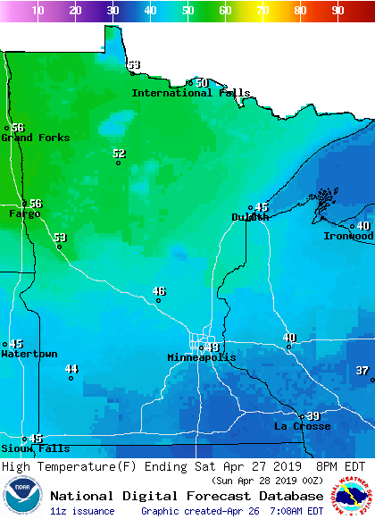
Saturday highs will be kind of upside-down, with warmest temps northwest and coolest temps southeast:
Sunday highs will be cool for late April:

Twin Cities metro area highs are projected to reach the lower 50s Monday and Wednesday, with mid 50s Tuesday and Thursday.
Saturday snow and mix
A low-pressure system moves across Iowa on Saturday, spinning moisture over about the southern third of Minnesota, plus southern Wisconsin. Temperature profiles in the models show mostly rain at first, then wet snow or a rain/snow mix for several hours tomorrow morning, tapering off Saturday afternoon.
The National Oceanic and Atmospheric Administration's North American Mesoscale forecast model shows the potential precipitation pattern from Friday evening through Saturday evening:

The color chart to the right of the loop refers to the strength of the signal that returns to the radar, not to the amount of snow and rain.
The heaviest snow is expected to fall over far southern Minnesota, where some areas could see 6 or more inches of accumulation.
The National Weather Service has issued a winter storm watch for south-central and southeastern Minnesota from 7 a.m. to 7 p.m. on Saturday:

The winter storm watch does not include the Twin Cities metro area. It looks like southern portions of Carver, Scott and Dakota county could see some minor snow accumulations on grassy areas on Saturday. Check forecast updates.
Here are more details on the winter storm watch to the south:
URGENT - WINTER WEATHER MESSAGE
National Weather Service Twin Cities/Chanhassen MN
315 AM CDT Fri Apr 26 2019
...Heavy Wet Snow Possible Across Southern Minnesota Saturday...
.A period of heavy snow is possible across southern Minnesota on
Saturday. Rain will arrive overnight tonight, but is expected to
change to snow early Saturday morning. The snow will be heavy at
times, with snowfall rates of 1-2" per hour possible between 7 AM
and 1 PM Saturday. The heaviest snowfall is expected near and
south of a line from Fairmont through Mankato to Lake City, with
the greatest amounts near the Interstate 90 corridor. Total
snowfall in much of the watch area is expected to exceed 6
inches, with local maximum amounts of near 9 inches possible. East
to northeast winds of 10 to 20 mph with gusts to 30 mph will
accompany the snowfall, which will lead to some blowing and
drifting. However, temperatures will be near freezing while it
snows, resulting in a heavy wet snow.
MNZ076>078-083>085-091>093-261800-
/O.NEW.KMPX.WS.A.0011.190427T1200Z-190428T0000Z/
Le Sueur-Rice-Goodhue-Blue Earth-Waseca-Steele-Martin-Faribault-
Freeborn-
Including the cities of Le Sueur, Faribault, Red Wing, Mankato,
Waseca, Owatonna, Fairmont, Blue Earth, and Albert Lea
315 AM CDT Fri Apr 26 2019
...WINTER STORM WATCH IN EFFECT FROM SATURDAY MORNING THROUGH
SATURDAY EVENING...
* WHAT...Heavy snow possible. Total snow accumulations of 3 to 8
inches possible.
* WHERE...Portions of south central and southeast Minnesota.
* WHEN...From Saturday morning through Saturday evening.
* ADDITIONAL DETAILS...East to northeast winds of 10 to 20 mph
with gusts to 30 mph are expected. Travel could be very
difficult.
PRECAUTIONARY/PREPAREDNESS ACTIONS...
A Winter Storm Watch means there is potential for significant
snow, sleet or ice accumulations that may impact travel. Continue
to monitor the latest forecasts.
You can check the latest forecasts from the weather service offices in the Twin Cities, Sioux Falls, S.D. and La Crosse, Wis.
As always, updated weather information can be heard on the Minnesota Public Radio Network, and you’ll also see updated weather info on the MPR News live weather blog.
Late April snowstorms
The bulk of the Saturday snow is expected to miss the Twin Cities metro area. The metro area has seen a few late April snowstorms over the years.
I've highlighted the record snow for April 27 of 8.5 inches and the 9.7 inches recorded April 29-30, 1984:

Programming note
You can hear my live weather updates on Minnesota Public Radio at 7:49 a.m. Thursdays and Fridays, and at 7:35 a.m., 9:35 a.m. and 4:35 p.m. each Saturday and Sunday.