Weekend snow watch: 6-12 inches possible for much of Minnesota
There's a lot of snow in our weekend forecast, but every March isn't snowy.
It's been several years since we've seen a really snowy March in the Twin Cities metro area.
Our average March snowfall was 10.2 inches for the 30-year period from 1981 through 2010:

Only one March (2013) in the past 10 has come in with a double-digit monthly snow total in the Twin Cities:
Create a More Connected Minnesota
MPR News is your trusted resource for the news you need. With your support, MPR News brings accessible, courageous journalism and authentic conversation to everyone - free of paywalls and barriers. Your gift makes a difference.

We didn't have any snow at all in March of 2010 and only 1.3 inches in March 2012!
You can impress you friends with additional Twin Cities snow data.
It's unfortunate that this snowy start to March is coming right on the heels of our February record snowfall (39 inches) in the Twin Cities.
Thursday snow
Far southern Minnesota could see some light snow showers this Thursday afternoon, with a few evening flurries possible in the Twin Cities.
Northern Minnesota will have a chance of some light snow showers overnight into early Friday.
The main snow event arrives on Saturday.
Weekend snowstorm
A major winter storm will bring heavy snow to much of Minnesota and parts of Wisconsin Saturday into Sunday.
The National Oceanic and Atmospheric Administration's North American Mesoscale forecast model shows the potential precipitation pattern from Saturday morning through Sunday evening:
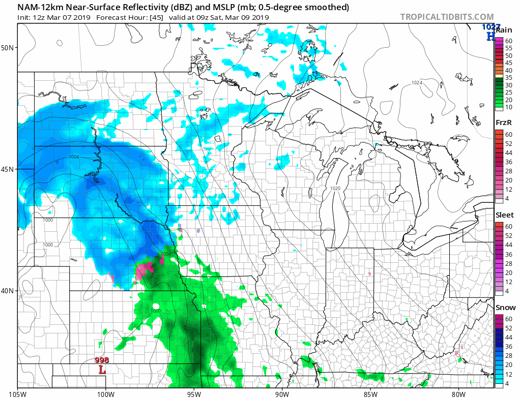
The color chart to the right of the loop refers to the strength of the signal that returns to the radar, not to the amount of snow or rain.
A winter storm watch has been issued by the National Weather Service for most of Minnesota and Wisconsin this weekend:
Notice that much of central and southern Minnesota, including the Twin Cities metro area, could see 8 to 12 inches of heavy, wet snow.
The winter storm watch starts at 6 a.m. Saturday in western Minnesota and far southern Minnesota, and it starts at 9 a.m. Saturday in the Twin Cities metro area. The winter storm watch starts at noon Saturday in Brainerd, Hinckley and Duluth, plus Hayward and Eau Claire, Wisconsin.
Here are more details of the winter storm watch:
URGENT - WINTER WEATHER MESSAGE
National Weather Service Twin Cities/Chanhassen MN
309 AM CST Thu Mar 7 2019
...MAJOR WINTER STORM EXPECTED SATURDAY INTO SUNDAY MORNING WITH
HEAVY SNOW LIKELY...
.A Winter Storm Watch has been issued across all of central and
southern Minnesota and western Wisconsin from Saturday through
Sunday morning.
Heavy snow will develop over the Plains and advance into southern
and western Minnesota early Saturday morning, before reaching
eastern Minnesota by late morning, and western Wisconsin by early
afternoon. Snow rates of 1 to 2 inches per hour are expected
through early evening before easing Saturday night. Some rain or
freezing rain could mix with the snow at times along I-90
Saturday. The snow is expected to end by mid morning Sunday. Total
snow accumulations of 7 to 13 inches are possible across the
entire region, with the highest amounts currently expected across
central Minnesota, including western parts of the Twin Cities
metro.
Strong northwest winds will develop Saturday night and Sunday
morning with gusts of 40 to 45 mph possible. This will lead to
areas of blowing and drifting snow, but widespread blizzard
conditions are not currently expected.
MNZ041>043-048>051-057>063-066>070-076>078-071715-
/O.NEW.KMPX.WS.A.0009.190309T1500Z-190310T1800Z/
Douglas-Todd-Morrison-Pope-Stearns-Benton-Sherburne-Kandiyohi-
Meeker-Wright-Hennepin-Anoka-Ramsey-Washington-McLeod-Sibley-
Carver-Scott-Dakota-Le Sueur-Rice-Goodhue-
Including the cities of Alexandria, Long Prairie, Little Falls,
Glenwood, St Cloud, Foley, Elk River, Willmar, Litchfield,
Monticello, Minneapolis, Blaine, St Paul, Stillwater, Hutchinson,
Gaylord, Chaska, Shakopee, Hastings, Le Sueur, Faribault,
and Red Wing
309 AM CST Thu Mar 7 2019
...WINTER STORM WATCH IN EFFECT FROM SATURDAY MORNING THROUGH
SUNDAY AFTERNOON...
* WHAT...Heavy snow possible. Total snow accumulations of 8 to 13
inches possible. Winds could gust as high as 35 mph.
* WHERE...Portions of central, east central, south central,
southeast and west central Minnesota.
* WHEN...From Saturday morning through Sunday afternoon.
* ADDITIONAL DETAILS...Travel could be very difficult. Patchy
blowing snow could significantly reduce visibility.
PRECAUTIONARY/PREPAREDNESS ACTIONS...
A Winter Storm Watch means there is potential for significant
snow, sleet or ice accumulations that may impact travel. Continue
to monitor the latest forecasts.
As always, updated weather information can be heard on the Minnesota Public Radio Network, and you’ll also see updated weather info on the MPR News live weather blog.
You can check the latest forecasts from the NWS offices in the Twin Cities, Grand Forks, N.D., Sioux Falls, S.D., La Crosse, Wis., and Duluth.
Temperature trends
Thursday afternoon highs will be mainly in the teens in western Minnesota, with lower 20s across much of the east.
Highs will be in the 20s across most of Minnesota on Friday, with some lower 30s southeast:

Many areas see 30s on Saturday:

20s and lower 30s are on tap for Sunday:

Metro area highs retreat to the upper 20s on Monday, followed by low to mid 30s Tuesday and Wednesday.
Programming note
You can hear my live weather updates on Minnesota Public Radio at 7:49 a.m. Thursdays and Fridays, and at 7:35 a.m., 9:35 a.m. and 4:35 p.m. each Saturday and Sunday.