Blizzard warnings in NW Minnesota; rain, flood watch for Twin Cities
An unusually strong low-pressure system is causing wild weather across much of the country Thursday.
Severe weather is possible from Louisiana and Alabama up to Michigan. Here's the severe weather outlook from the National Weather Service Storm Prediction Center:

Denver is still recovering from this powerful low pressure system, which hit them with heavy snow and wind gusts of 90 mph yesterday:
Note: "bomb cyclone" refers to a low pressure system which strengthens rapidly, with a central pressure drop of 24 millibars or greater in 24 hours.
Create a More Connected Minnesota
MPR News is your trusted resource for the news you need. With your support, MPR News brings accessible, courageous journalism and authentic conversation to everyone - free of paywalls and barriers. Your gift makes a difference.
Parts of Minnesota will see mainly rain from this system, others will have snow and very strong winds.
The National Oceanic and Atmospheric Administration's North American Mesoscale forecast model shows the potential precipitation pattern Thursday and Thursday night:

There are blizzard warnings for the Dakotas and northwestern Minnesota plus Traverse and Big Stone counties in west-central Minnesota:
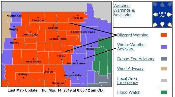
Here are details of the blizzard warning in northwestern Minnesota:
URGENT - WINTER WEATHER MESSAGE
National Weather Service Grand Forks ND
745 AM CDT Thu Mar 14 2019
MNZ001-002-004-005-007-008-013>015-NDZ008-016-026>030-150600-
/O.CON.KFGF.BZ.W.0005.000000T0000Z-190315T0600Z/
West Polk-Norman-Kittson-Roseau-West Marshall-East Marshall-
Pennington-Red Lake-East Polk-Pembina-Eastern Walsh County-Nelson-
Grand Forks-Griggs-Steele-Traill-
Including the cities of Crookston, East Grand Forks, Ada,
Twin Valley, Halstad, Hallock, Karlstad, Lancaster, Roseau,
Warroad, Greenbush, Warren, Stephen, Argyle, Newfolden,
Middle River, Grygla, Thief River Falls, Red Lake Falls, Fosston,
Fertile, McIntosh, Erskine, Cavalier, Walhalla, Drayton, Pembina,
Neche, St. Thomas, Grafton, Park River, Lakota, Mcville, Aneta,
Tolna, Grand Forks, Cooperstown, Finley, Hope, Mayville,
Hillsboro, Hatton, and Portland
745 AM CDT Thu Mar 14 2019
...BLIZZARD WARNING REMAINS IN EFFECT UNTIL 1 AM CDT FRIDAY...
* WHAT...Blizzard conditions, mainly in open country. Additional
snow accumulations of up to two inches. Winds gusting as high as
55 mph.
* WHERE...Portions of northwest Minnesota and northeast and
southeast North Dakota.
* WHEN...Until 1 AM CDT Friday.
* ADDITIONAL DETAILS...Plan on slippery road conditions.
Widespread blowing snow could significantly reduce visibility.
The hazardous conditions could impact the evening commute.
Strong winds could cause tree damage.
PRECAUTIONARY/PREPAREDNESS ACTIONS...
A Blizzard Warning means severe winter weather conditions are
expected or occurring. Falling and blowing snow with strong winds
and poor visibilities are likely. This will lead to whiteout
conditions, making travel extremely dangerous. Do not travel. If
you must travel, have a winter survival kit with you. If you get
stranded, stay with your vehicle.
The latest road conditions for North Dakota can be found at
dot.nd.gov/travel and for Minnesota at 511mn.org, or by calling
5 1 1 in either state.
Here's the Thursday morning summary from the NWS office in Grand Forks, N.D.:

Eastern Minnesota and the metro area
Eastern Minnesota, including the Twin Cities metro area, will have periods of rain Thursday with a few embedded storms possible. A dense fog advisory runs until 10 a.m., and a flood watch continues until 7 p.m.
Snow melt and rain could cause some localized flooding in poorly drained areas:

All the counties for which the Twin Cities NWS office has forecast responsibility are in an area flood watch, and some counties also have winter weather advisories or wind advisories:

Here are details of the flood watch that includes the Twin Cities metro area until 7 p.m. Thursday:
Flood Watch
National Weather Service Twin Cities/Chanhassen MN
345 AM CDT Thu Mar 14 2019
...RAIN AND SNOW MELT COULD LEAD TO STREET FLOODING AND PONDING
OF WATER IN LOW LYING AREAS THROUGH THURSDAY...
.Temperatures will remain mild through Thursday afternoon.
Periods of rain during the day Thursday will combine with snow
melt to produce street flooding and standing water over low lying
areas. The next batch of heavier rainfall will occur in western
and central Minnesota between sunrise and midday Thursday, with
amounts of around one half inch likely. Significant rises on the
main stem rivers are not expected this week.
Many of the the drainage systems are full of ice and snow, so any
melting or runoff from the rain could lead to ponding of water in
low lying areas. Temperatures will fall below freezing Friday, so
any standing water will become ice.
MNZ041>045-047>070-073>077-082>085-091>093-141645-
/O.CON.KMPX.FA.A.0001.000000T0000Z-190315T0000Z/
/00000.0.RS.000000T0000Z.000000T0000Z.000000T0000Z.OO/
Douglas-Todd-Morrison-Mille Lacs-Kanabec-Stevens-Pope-Stearns-
Benton-Sherburne-Isanti-Chisago-Lac Qui Parle-Swift-Chippewa-
Kandiyohi-Meeker-Wright-Hennepin-Anoka-Ramsey-Washington-
Yellow Medicine-Renville-McLeod-Sibley-Carver-Scott-Dakota-
Redwood-Brown-Nicollet-Le Sueur-Rice-Watonwan-Blue Earth-Waseca-
Steele-Martin-Faribault-Freeborn-
Including the cities of Alexandria, Long Prairie, Little Falls,
Princeton, Mora, Morris, Glenwood, St Cloud, Foley, Elk River,
Cambridge, Center City, Madison, Benson, Montevideo, Willmar,
Litchfield, Monticello, Minneapolis, Blaine, St Paul, Stillwater,
Granite Falls, Olivia, Hutchinson, Gaylord, Chaska, Shakopee,
Hastings, Redwood Falls, New Ulm, St Peter, Le Sueur, Faribault,
St James, Mankato, Waseca, Owatonna, Fairmont, Blue Earth,
and Albert Lea
345 AM CDT Thu Mar 14 2019
...FLOOD WATCH REMAINS IN EFFECT THROUGH THIS EVENING...
The Flood Watch continues for
* Portions of central Minnesota, east central Minnesota, south
central Minnesota, southwest Minnesota, and west central
Minnesota, including the following areas, in central
Minnesota, Benton, Kandiyohi, McLeod, Meeker, Morrison,
Renville, Sherburne, Sibley, Stearns, Todd, and Wright. In
east central Minnesota, Anoka, Carver, Chisago, Dakota,
Hennepin, Isanti, Kanabec, Mille Lacs, Ramsey, Scott, and
Washington. In south central Minnesota, Blue Earth, Brown,
Faribault, Freeborn, Le Sueur, Martin, Nicollet, Rice, Steele,
Waseca, and Watonwan. In southwest Minnesota, Redwood. In west
central Minnesota, Chippewa, Douglas, Lac Qui Parle, Pope,
Stevens, Swift, and Yellow Medicine.
* Through this evening
* Snow melt and rainfall may result in flooding in poor drainage
areas.
PRECAUTIONARY/PREPAREDNESS ACTIONS...
A Flood Watch means there is a potential for flooding based on
current forecasts. Clear the snow and ice away from your storm
drains before Wednesday.
You should monitor later forecasts and be alert for possible
Flood Warnings. Those living in areas prone to flooding should be
prepared to take action should flooding develop.
______________________________________________________________
10:30 a.m. update
Goodhue county, eastern Rice county and the far southern part of Dakota county are included in a flood warning until 10:15 p.m. this Thursday:

Here are the details:
Flood Warning
National Weather Service Twin Cities/Chanhassen MN
1027 AM CDT THU MAR 14 2019
MNC037-049-131-150315-
/O.NEW.KMPX.FA.W.0002.190314T1527Z-190315T0315Z/
/00000.0.RS.000000T0000Z.000000T0000Z.000000T0000Z.OO/
Dakota MN-Goodhue MN-Rice MN-
1027 AM CDT THU MAR 14 2019
The National Weather Service in The Twin Cities has issued a
* Flood Warning for...
Rain and Snowmelt in...
Southern Dakota County in east central Minnesota...
Goodhue County in southeastern Minnesota...
Eastern Rice County in south central Minnesota...
* Until 1015 PM CDT Thursday.
* At 1018 AM CDT, the public reported flooding along tributaries of
the Cannon, and Straight Rivers in southeast Minnesota. A few
rural roads were flooded near Dennison, and some areas had
standing or flowing flood waters in the warned area. River gauges
in the warned area also indicated significant rises since last
night. Until the runoff is complete from snow melt and rainfall
over the past two days, flooding will continue in the warned
areas. Later tonight, a cold front will move across the warned
area and this will lead to ice forming where the water is
currently flowing or ponding.
Since Tuesday, rainfall amounts of 1 to 1.5 inches has fallen over
the warned area, and snow has melted significant as temperatures
have risen above freezing.
PRECAUTIONARY/PREPAREDNESS ACTIONS...
Please report flooding to your local law enforcement agency when you
can do so safely.
_____________________________________________________________________
The Twin Cities metro area rain could mix with snow by 6 p.m. or 7 p.m., then we’ll probably have some periods of light snow as we go through Thursday evening.
Northeastern Minnesota remains in a flood watch until 7 p.m. today:

A flood watch continues until 7 a.m. Friday in southeastern Minnesota and parts of western Wisconsin.
Updates
As always, updated weather information can be heard on the Minnesota Public Radio Network, and you’ll also see updated weather info on the MPR News live weather blog.
You can check the latest forecasts from the NWS offices in the Twin Cities, Grand Forks, N.D., Sioux Falls, S.D., La Crosse, Wis., and Duluth.
Temperature trends
Minnesota highs will be mainly in the 30s Thursday afternoon, with some lower 40s in the east.
Highs Friday will be in the 20s northwest, and in the 30s elsewhere:

Saturday will be in the 30s:

And 30s will linger on Sunday:

Twin Cities metro area highs reach around 40 degrees on Monday, followed by lower 40s Tuesday and mid 40s on Wednesday.
Programming note
You can hear my live weather updates on Minnesota Public Radio at 7:49 a.m. Thursdays and Fridays, and at 7:35 a.m., 9:35 a.m. and 4:35 p.m. each Saturday and Sunday.