Winds howl and temps fall; amazing February snow stats
Window-rattling winds will linger across Minnesota and western Wisconsin through Sunday afternoon. Blowing and drifting snow will severely reduce visibilities and make travel difficult in much of Minnesota and Wisconsin.
Big picture
The accumulating snow has ended in many areas, but snow continues into this afternoon in much of northeastern Minnesota and northern Wisconsin.
The National Oceanic and Atmospheric Administration’s North American Mesoscale forecast model shows the potential precipitation pattern this Sunday afternoon and evening:
Create a More Connected Minnesota
MPR News is your trusted resource for the news you need. With your support, MPR News brings accessible, courageous journalism and authentic conversation to everyone - free of paywalls and barriers. Your gift makes a difference.

Scattered very light snow showers or flurries are possible in some additional spots around Minnesota and western Wisconsin where no snow is indicated in the NAM simulated radar loop.
Warnings
Blizzard warnings continue until 6 p.m. this Sunday in much of western, central and southern Minnesota, plus Carver, Scott and Dakota counties of the south metro. Strong winds gusting to 50 mph will cause reduced visibilities and even whiteout conditions at times, especially in open areas.
Here's the warning map, as of mid-morning:

Here’s the NWS winter storm discussion, followed by the blizzard warning details:
URGENT - WINTER WEATHER MESSAGE
National Weather Service Twin Cities/Chanhassen MN
625 AM CST Sun Feb 24 2019
...DANGEROUS WINTER STORM CONTINUES TODAY AS WINDS INCREASE WITH
WIDESPREAD BLOWING SNOW...
.A Blizzard Warning will continue through Sunday afternoon for
most locations in Minnesota and Wisconsin along and south of I-
94. This includes southern portions of the Twin Cities metro,
away from more suburban areas, as well as Ladysmith, Chippewa
Falls, and Eau Claire Wisconsin. A Winter Storm Warning is in
effect through Sunday afternoon from the core of the Twin Cities
metro northward along I-35 including Polk and Barron counties. A
Winter Weather Advisory is in effect for the counties north of
I-94 and west of I-35.
Snow will end across Wisconsin this morning but winds will
increase after sunrise. Wind gusts near 50 mph are expected,
which will result in widespread whiteout conditions in the
Blizzard Warning area. Travel will be very dangerous or
impossible as roads become drifted shut. Road closures have been
reported. DO NOT TRAVEL.
MNZ067-069-070-074>076-WIZ023-242030-
/O.CON.KMPX.BZ.W.0003.000000T0000Z-190225T0000Z/
Sibley-Scott-Dakota-Brown-Nicollet-Le Sueur-St. Croix-
Including the cities of Gaylord, Shakopee, Hastings, New Ulm,
St Peter, Le Sueur, and Hudson
625 AM CST Sun Feb 24 2019
...BLIZZARD WARNING REMAINS IN EFFECT UNTIL 6 PM CST THIS
EVENING...
* WHAT...Blizzard conditions expected. Winds gusting as high as
50 mph.
* WHERE...Portions of central, east central and south central
Minnesota.
* WHEN...Until 6 PM CST Sunday.
* ADDITIONAL DETAILS...Travel will be very difficult with some
roads becoming impassable. Areas of blowing snow could
significantly reduce visibility. Gusty winds could bring down
tree branches.
PRECAUTIONARY/PREPAREDNESS ACTIONS...
A Blizzard Warning means severe winter weather conditions are
expected or occurring. Falling and blowing snow with strong winds
and poor visibilities are likely. This will lead to whiteout
conditions, making travel extremely dangerous. Do not travel. If
you must travel, have a winter survival kit with you. If you get
stranded, stay with your vehicle.
The latest road conditions for Minnesota can be found at
511mn.org and for Wisconsin at 511wi.gov, or by calling 5 1 1 in
either state.
Minneapolis, St. Paul and the north metro are in a winter storm warning until 6 p.m., due to wind gusts to 40-45 mph and reduced visibilities in blowing and drifting snow.
A blizzard warning covers portions of Lake and Cook counties along the North Shore of Lake Superior:

The Duluth area and much of northern Minnesota are in a winter weather advisory.
As always, updated weather information can be heard on the Minnesota Public Radio Network, and you’ll also see updated weather info on the MPR News live weather blog.
You can check the latest forecasts from the NWS offices in the Twin Cities, Grand Forks, N.D., Sioux Falls, S.D., La Crosse, Wis. and Duluth.
Updated road conditions will be posted by the Minnesota and Wisconsin transportation departments.
Roads are closed in parts of southern Minnesota this morning:
Snow totals
We keep padding our Twin Cities February snow stats:
Our average Twin Cities snowfall total is only 7.7 inches for the month of February!
February 2019 has the 6th highest monthly snowfall total in Twin Cities snowfall records, which go back to 1884:
Some additional snow totals from Saturday evening through the overnight hours of Saturday night: 12 inches at Chatfield, which is southeast of Rochester, 11 inches in Rochester, Wabasha and Eau Claire. Winona and Austin reported 10 inches.
You can check snow accumulations as they are posted by the National Weather Service. Hover over a location on the National Weather Service snow map site to see the snow total and the time of observation.
Here's a snapshot of the snowfall map from mid-morning on Sunday:

There's also a county by county snowfall list.
Temperatures fall
The temperature was 29 degrees at Minneapolis-St. Paul International Airport around midnight Saturday night. That will go down as our high temp for today. The temperature has been falling since midnight, and it will reach the single digits at some point later this afternoon. Falling temps are common today across Minnesota and western Wisconsin. Wind chills will be well below zero in many locations.
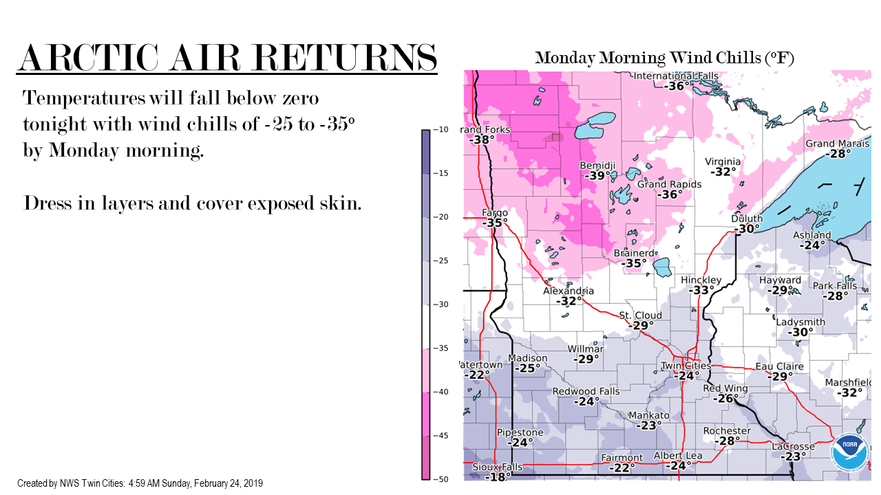
Be ready for cold temps and wind chills on Monday:
Monday highs stay in the single digits:

A few spots in the Twin Cities metro area could touch 10 degrees on Monday. Metro area highs are projected to reach the lower teens Tuesday, followed by mid teens Wednesday and lower 20s Thursday and Friday. Our average Twin Cities high temp is in the lower 30s this time of year.
Programming note
You can hear live weekend weather updates with Minnesota Public Radio meteorologists at 7:35 a.m., 9:35 a.m. and 4:35 p.m. each Saturday and Sunday.