Brace for the cold, enjoy the sunshine
It'll be a bright Friday, but temps will be running about 25 degrees below average.
There will be enough wind to generate wind chills in the -25 to -35 range in the Twin Cities metro area and much of eastern Minnesota, where the wind chill advisory continues until noon:

A wind chill warning for even colder wind chills covers western Minnesota.
Temperature trends
Create a More Connected Minnesota
MPR News is your trusted resource for the news you need. With your support, MPR News brings accessible, courageous journalism and authentic conversation to everyone - free of paywalls and barriers. Your gift makes a difference.
Friday afternoon highs stay slightly below zero across most of Minnesota:

Parts of the Twin Cities metro area could touch zero.
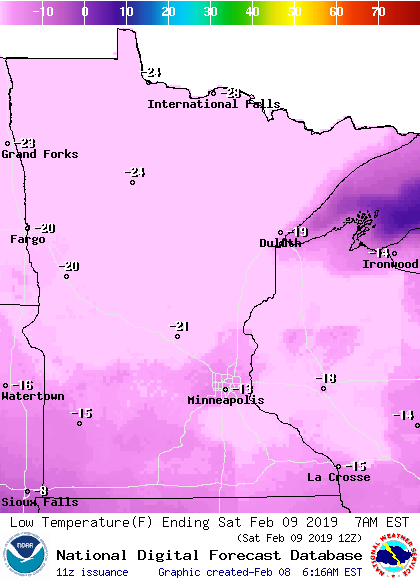
Lows tonight will be in the 20s below zero in much of Minnesota, with teens below in the inner portion of the metro area and parts of southern Minnesota:
Saturday highs reach double-digits above zero in the metro area and southern Minnesota:

Highs in the teens will be common in central and southern Minnesota on Sunday:

It still looks like the metro area will have highs in the lower 20s next Monday and Tuesday.
Snow totals
The Thursday snow total at Minneapolis-St. Paul International Airport was 5.9 inches.
You can check snow accumulations as they are posted by the National Weather Service. Hover over a location on the NWS snow map to see the snow total and the time of observation.
Updated road conditions will be posted by the Minnesota and Wisconsin transportation departments.
This Updraft blog will be updated around mid-morning.
Programming note
You can hear my live weather updates on Minnesota Public Radio at 7:49 a.m. Thursdays and Fridays, and at 7:35 a.m., 9:35 a.m. and 4:35 p.m. each Saturday and Sunday.