Polar vortex ahead? Bitter air mass coming south
Welcome to the warmest day for the rest of January in Minnesota.
The northern hemisphere upper air pattern is about to change dramatically. A series of cold fronts sails south over the next two weeks. The first front blows into Minnesota Tuesday night. A stronger arctic front drives south Thursday.
And the long-range maps continue to suggest a full-latitude trough driving bitter cold into the eastern half of the United States all the way south to Florida. It looks like an elongated version of the Polar vortex is on the way.

Warmest day for the rest of January?
Create a More Connected Minnesota
MPR News is your trusted resource for the news you need. With your support, MPR News brings accessible, courageous journalism and authentic conversation to everyone - free of paywalls and barriers. Your gift makes a difference.
Tuesday is likely to be the warmest day for the rest of this month. Our first cold wave arrives in earnest Thursday and bottoms out Sunday morning.
We're likely to see temperatures dip below zero for the first time this winter season Sunday morning. That would be the latest on record.

Subzero wind chills invade Minnesota as soon as this weekend. Time to stock up on the essentials for a weekend Netflix binge?
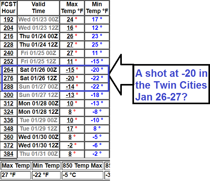
A shot at minus 20 in the Twin Cities?
Temperatures rebound a few degrees next week. Then the mother lode of cold air appears ready to blow in the weekend of Jan. 26-27.
Various model runs from the National Oceanic and Atmospheric Administration's 16-day temperature output have been cranking out temperatures approaching minus 20 in the Twin Cities in about 12 days.
That may be overdone, but the notion of at least -10s in the Twin Cities and minus 30s to minus 40 up north appears to be growing.
Tree-cracking cold.
Southern storm track continues
Searching for snow? Head north. Or south.
The Twin Cities and southern Minnesota lie between two snowfall maxima this winter. There's plenty of snow north of Minneapolis-St. Paul and across southern Iowa and Missouri.

The southern storm track continues to dump heavy snow across Iowa and Missouri. The next one arrives Friday.
Never a dull moment.