A slow go on Monday; Snowstorm update and the latest on incredibly cold mid-week temps
Most of Minnesota will see plenty of snow Sunday evening through the overnight hours of Sunday night.
The snow tapers of from west to east Monday morning.
The National Oceanic and Atmospheric Administration’s North American Mesoscale forecast model shows the potential snow pattern from Sunday evening through Monday:
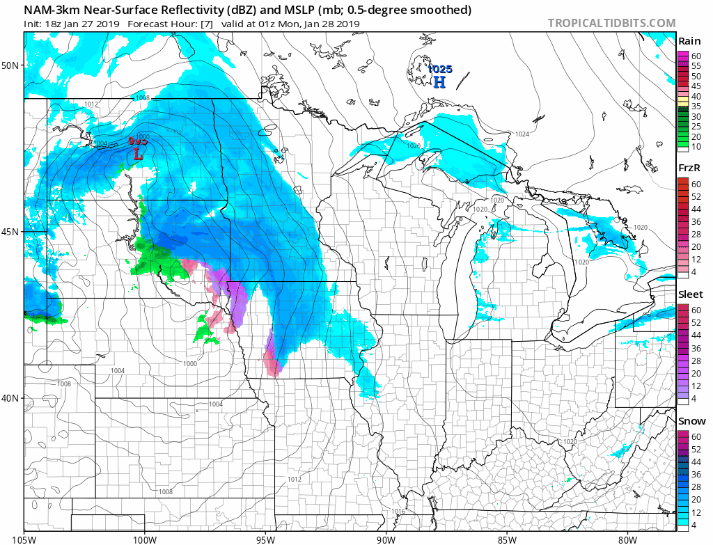
The main snow area leaves the Twin Cities by midday on Monday, but you'll notice that a batch of lighter snow moves over the metro area late on Monday.
Create a More Connected Minnesota
MPR News is your trusted resource for the news you need. With your support, MPR News brings accessible, courageous journalism and authentic conversation to everyone - free of paywalls and barriers. Your gift makes a difference.
The color chart to the right of the loop refers to the strength of the signal that returns to the radar, not to the amount of snow.
The greatest snow accumulations (8 inches or more) are expected from west-central Minnesota through the Twin Cities metro area into southeastern Minnesota and west-central Wisconsin.
Here’s the National Weather Service snow forecast from Sunday evening through Monday:

In the graphic title, "tonight" refers to Sunday evening through the overnight hours of Sunday night.
In the Twin Cities metro area, the highest snow totals are expected in the south metro, where I wouldn't be surprised to see some 9 and 10 inch totals. In the far north metro, snow amounts could be closer to 7 inches.
_____________________________________________________
11 p.m. update
Seeing some 3 to 4 inch snow totals so far in the Twin Cities metro area. Radar trends and new computer model info indicate that an additional 2 to 4 inches of snow are possible in the Twin Cities metro area overnight. ____________________________________________________
Chemicals don't work well in cold temps, so I expect some slick roads, highways and ramps during the Monday morning commute.
You can check snow accumulations for Minnesota and western Wisconsin as they are posted by the NWS. Hover over a location on the NWS snow map to see the snow total and the time of observation.
Updated road conditions will be posted by the Minnesota and Wisconsin transportation departments.
Warnings and advisories
The National Weather Service continues winter storm warnings Sunday evening through Monday morning across most of central and southern Minnesota and parts of western Wisconsin:

Details of the winter storm warning:
URGENT - WINTER WEATHER MESSAGE
National Weather Service Twin Cities/Chanhassen MN
325 PM CST Sun Jan 27 2019
...HEAVY SNOW AND BLOWING SNOW SUNDAY AFTERNOON THROUGH EARLY
MONDAY...
...DANGEROUS WIND CHILLS TUESDAY THROUGH THURSDAY MORNING...
.Accumulating snow, moderate to heavy at times, will occur across
all of central and southern Minnesota into western Wisconsin
Sunday afternoon through early Monday morning. The greatest snow
accumulations will stretch from west central Minnesota through the
Twin Cities metro to around the Eau Claire area, with lesser
amounts towards northern Minnesota, southwestern Minnesota and
northwestern Wisconsin. This system is expected to cause
significant travel impacts, especially Sunday night through the
Monday morning commute.
Winter Storm Warnings are in place for all of central and southern
Minnesota into west central Wisconsin, with the exception of
Martin County Minnesota which remains in a Winter Weather
Advisory.
Snowfall amounts in the warning area can be expected to range
from 6 to 12 inches. Snowfall amounts in the advisory area can be
expected to range from 3 to 6 inches.
Dangerous wind chills as low as 60 below zero are expected
Tuesday morning through Thursday morning in western and central
Minnesota. Wind chills as low as 50 below zero are expected
Tuesday afternoon through Thursday morning in east central MN and
west central Minnesota.
MNZ053-059>063-068>070-078-280600-
/O.CON.KMPX.WS.W.0002.000000T0000Z-190128T1800Z/
/O.CON.KMPX.WC.A.0001.190129T2100Z-190131T1500Z/
Chisago-Wright-Hennepin-Anoka-Ramsey-Washington-Carver-Scott-
Dakota-Goodhue-
Including the cities of Center City, Monticello, Minneapolis,
Blaine, St Paul, Stillwater, Chaska, Shakopee, Hastings,
and Red Wing
325 PM CST Sun Jan 27 2019
...WINTER STORM WARNING REMAINS IN EFFECT UNTIL NOON CST MONDAY...
...WIND CHILL WATCH REMAINS IN EFFECT FROM TUESDAY AFTERNOON
THROUGH THURSDAY MORNING...
* WHAT...Heavy snow. Dangerously cold wind chills possible.
Additional snow accumulations of 7 to 11 inches with isolated
locations close to a foot of snow. Wind chills
as low as 50 below zero likely.
* WHERE...Portions of central, east central and southeast
Minnesota.
* WHEN...For the Winter Storm Warning, until noon CST Monday.
For the Wind Chill Watch, from Tuesday afternoon through
Thursday morning.
* ADDITIONAL DETAILS...Travel could be very difficult. Patchy
blowing snow could significantly reduce visibility. The
hazardous conditions could impact the morning or evening
commute. The dangerously cold wind chills could cause
frostbite on exposed skin in as little as 5 minutes.
PRECAUTIONARY/PREPAREDNESS ACTIONS...
A Winter Storm Warning for snow means severe winter weather
conditions will make travel very hazardous or impossible. If you
must travel, keep an extra flashlight, food and water in your
vehicle in case of an emergency.
A Wind Chill Watch means there is the potential for a combination
of very cold air and the wind to create dangerously low wind
chill values. Monitor the latest forecasts and warnings for
updates on this situation.
The latest road conditions for Minnesota can be found at
511mn.org and for Wisconsin at 511wi.gov, or by calling 5 1 1 in
either state.
A blizzard warning is in effect overnight Sunday night for portions of northwestern Minnesota:

Details of the blizzard warning:
URGENT - WINTER WEATHER MESSAGE
National Weather Service Grand Forks ND
255 PM CST Sun Jan 27 2019
MNZ001>004-007-013>015-022-027>031-040-NDZ008-016-027-029-030-039-
053-281800-
/O.UPG.KFGF.WS.W.0001.000000T0000Z-190128T1800Z/
/O.EXB.KFGF.BZ.W.0002.190127T2055Z-190128T1200Z/
/O.EXB.KFGF.WW.Y.0038.190128T1200Z-190128T1800Z/
West Polk-Norman-Clay-Kittson-West Marshall-Pennington-Red Lake-
East Polk-Mahnomen-West Becker-East Becker-Wilkin-West Otter Tail-
East Otter Tail-Grant-Pembina-Eastern Walsh County-Grand Forks-
Steele-Traill-Cass-Richland-
Including the cities of Crookston, East Grand Forks, Ada,
Twin Valley, Halstad, Moorhead, Hallock, Karlstad, Lancaster,
Warren, Stephen, Argyle, Thief River Falls, Red Lake Falls,
Fosston, Fertile, McIntosh, Erskine, Mahnomen, Naytahwaush,
Waubun, Detroit Lakes, Wolf Lake, Breckenridge, Fergus Falls,
Perham, New York Mills, Parkers Prairie, Henning, Battle Lake,
Elbow Lake, Hoffman, Ashby, Herman, Barrett, Cavalier, Walhalla,
Drayton, Pembina, Neche, St. Thomas, Grafton, Park River,
Grand Forks, Finley, Hope, Mayville, Hillsboro, Hatton, Portland,
Fargo, and Wahpeton
255 PM CST Sun Jan 27 2019
...BLIZZARD WARNING IN EFFECT UNTIL 6 AM CST MONDAY...
...WINTER WEATHER ADVISORY IN EFFECT FROM 6 AM TO NOON CST
MONDAY...
* WHAT...Heavy snow and blizzard conditions expected. Total snow
accumulations of 4 to 7 inches expected. Winds gusting as high
as 35 mph will cause whiteout conditions, mainly in open country.
Wind chills as low as 35 below zero tonight.
* WHERE...Portions of northwest and west central Minnesota and
northeast and southeast North Dakota.
* WHEN...For the Blizzard Warning, until 6 AM CST Monday. For
the Winter Weather Advisory, from 6 AM to noon CST Monday.
* ADDITIONAL DETAILS...Plan on slippery road conditions.
Widespread blowing snow could significantly reduce visibility.
The hazardous conditions could impact the morning commute. The
dangerously cold wind chills as low as 35 below zero could
cause frostbite on exposed skin in as little as 10 minutes.
PRECAUTIONARY/PREPAREDNESS ACTIONS...
A Blizzard Warning means severe winter weather conditions are
expected or occurring. Falling and blowing snow with strong winds
and poor visibilities are likely. This will lead to whiteout
conditions, making travel extremely dangerous. Do not travel. If
you must travel, have a winter survival kit with you. If you get
stranded, stay with your vehicle.
A Winter Weather Advisory for snow means periods of snow will
cause primarily travel difficulties. Expect snow covered roads
and limited visibilities, and use caution while driving.
The latest road conditions for North Dakota can be found at
dot.nd.gov/travel and for Minnesota at 511mn.org, or by calling
5 1 1 in either state.
Northeastern Minnesota has some warnings and advisories as well:

You can check the latest forecasts, warnings and advisories from the NWS offices in the Twin Cities, Grand Forks, N.D., Sioux Falls, S.D., La Crosse, Wis and Duluth.
As always, updated weather information can be heard on the Minnesota Public Radio Network, and you’ll also see updated weather info on the MPR News live weather blog.
Incredibly cold by midweek
Monday highs are expected to be in the single digits across most of Minnesota, with some lower teens southeast:

Tuesday highs are below zero statewide:

Low temps late Tuesday night and early Wednesday are expected to be in the 20s below zero in southern Minnesota, with 30s below and possibly some 40s below zero in the north.
Wednesday highs will be incredibly cold:

Our low temps Wednesday and Thursday morning are expected to be around 24 degrees below zero. The Thursday high temp will be a few degrees below zero. Metro temps rebound to a high of about 14 above zero on Friday, and we could reach the lower 30s next Saturday. That’ll feel nice after several days of arctic cold!
Wind chills across Minnesota and western Wisconsin are expected to be in the -40 to -60 degree range Tuesday morning through Thursday morning.
Here are some examples:

The dark blue line on the chart shows the projected wind chill readings in the Twin Cities metro area.
Coldest since 1996?
If the temperature at Minneapolis-St. Paul International Airport hits -24 on Wednesday, it will tie with Jan. 30, 2004 as the coldest Twin Cities low temp since Dec. 26, 1996, when we dipped to -27. If we hit -25, which seems possible, it will stand alone as our coldest low temperature in the Twin Cities since 1996.
I checked weather data for Minneapolis-St. Paul International Airport and found low temps of -20 or colder on six consecutive days in 1996:
On Feb. 2, 1996 the MSP airport temperature hit -32. High temps are to the left of the low temps, and the highs were below zero on four of those six days!