A mild Sunday and Monday, arctic chill later in the week; east coast snow
It seems strange to say "mild" when Twin Cities high temps are only in the lower 30s, but this is January in Minnesota, and much colder temps are possible this time of year.
Temperature trends
Sunday afternoon highs are expected to reach the lower 30s across much of the southern half of Minnesota, with mainly 20s in the northern half.
On Monday, 30s are most likely in the southeastern half of Minnesota, with 20s to the northwest:
Create a More Connected Minnesota
MPR News is your trusted resource for the news you need. With your support, MPR News brings accessible, courageous journalism and authentic conversation to everyone - free of paywalls and barriers. Your gift makes a difference.

Our average high this time of year is only 23 degrees in the Twin Cities metro area.
Metro area highs are projected to reach the mid 30s Tuesday, then dip closer to normal on Wednesday, with mid 20s. We’ll probably reach the upper 20s on Thursday. Much colder air arrives on Friday, with a high in the upper teens. Arctic chill will probably be with us next weekend, with metro area highs in the teens.
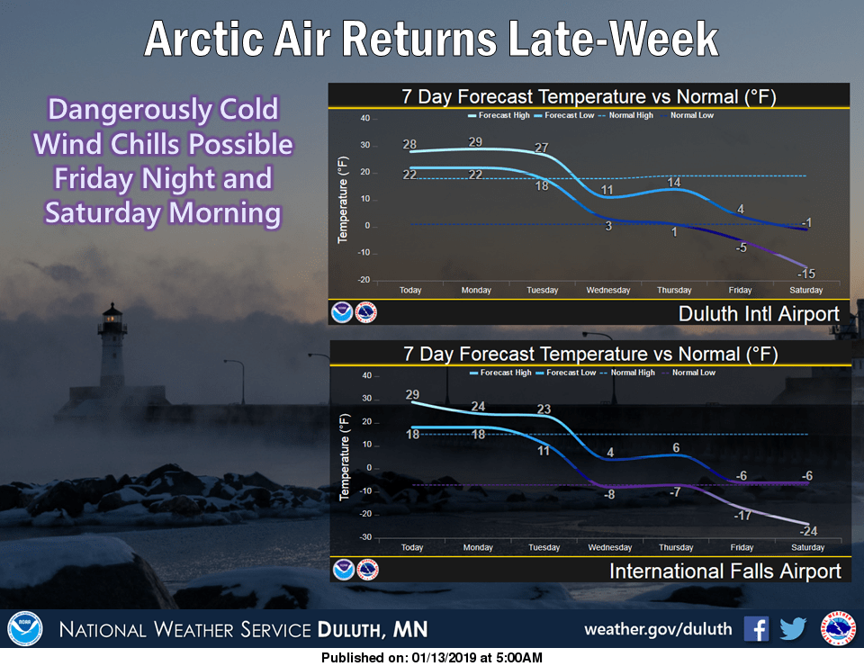
The arctic chill arrives mid-week in Duluth and International Falls:
First dip below zero?
Minneapolis-St. Paul International Airport hasn't seen a sub-zero reading this winter and there weren't any sub-zero readings this past autumn at that location. MSP airport did have a low temp of zero on January 1. According to the Minnesota State Climatology Office, the long-term average for our first official below-zero reading in the Twin Cities is December 8. Our earliest first sub-zero reading of autumn in the Twin Cities was November 4, 1991…that was shortly after the famous Halloween Blizzard of 1991.
We could see the MSP airport temperature dip below zero late Friday night or early Saturday, as well as late Saturday night or early next Sunday.
Snow chances
Patchy light snow showers are possible in portions of northern and central Minnesota Sunday evening through Monday morning.
The National Oceanic and Atmospheric Administration’s North American Mesoscale forecast model shows the potential precipitation pattern from Sunday evening through Monday afternoon:

The color chart to the right of the loop refers to the strength of the signal that returns to the radar, not to the amount of snow.
As always, updated weather information can be heard on the Minnesota Public Radio Network, and you’ll also see updated weather info on the MPR News live weather blog.
East coast snow
It's a snowy Sunday in Washington, D.C.:
The NAM forecast model shows the potential precipitation pattern from Sunday morning through Sunday night:

You can go to weather.gov and click on any location for forecasts and warning/advisory details.
Programming note
You can hear my live weather updates on Minnesota Public Radio at 7:49 a.m. Thursdays and Fridays, and at 7:35 a.m., 9:35 a.m. and 4:35 p.m. each Saturday and Sunday.