Snow totals revisited; windy and colder today, mild temps return on Sunday
The winter storm is moving away, but many Minnesotans and residents of neighboring states will be shoveling and plowing today.
Travel remains difficult across much of Minnesota this morning:
Winds are very strong in western Minnesota today, and it's breezy in the east.
A blizzard warning continues until noon today in Traverse and Big Stone counties of west-central Minnesota::
Create a More Connected Minnesota
MPR News is your trusted resource for the news you need. With your support, MPR News brings accessible, courageous journalism and authentic conversation to everyone - free of paywalls and barriers. Your gift makes a difference.
URGENT - WINTER WEATHER MESSAGE
National Weather Service Aberdeen SD
855 AM CST Fri Dec 28 2018
MNZ039-046-SDZ007-008-011-019>023-281800-
/O.EXT.KABR.BZ.W.0004.000000T0000Z-181228T1800Z/
Traverse-Big Stone-Marshall-Roberts-Day-Clark-Codington-Grant-
Hamlin-Deuel-
Including the cities of Wheaton, Ortonville, Britton, Sisseton,
Webster, Clark, Watertown, Milbank, Hayti, and Clear Lake
855 AM CST Fri Dec 28 2018
...BLIZZARD WARNING NOW IN EFFECT UNTIL NOON CST TODAY...
* WHAT...Blizzard conditions. No additional snowfall. Winds
gusting as high as 45 mph.
* WHERE...Portions of northeast South Dakota and west central
Minnesota.
* WHEN...Until noon CST today.
* ADDITIONAL DETAILS...Plan on slippery road conditions. Areas
of blowing snow could significantly reduce visibility. The
hazardous conditions could impact the morning commute.
PRECAUTIONARY/PREPAREDNESS ACTIONS...
A Blizzard Warning means severe winter weather conditions are
expected or occurring. Blowing snow with strong winds and poor
visibilities are likely. This will lead to whiteout conditions,
making travel extremely dangerous. Do not travel. If you must
travel, have a winter survival kit with you. If you get stranded,
stay with your vehicle.
The cold wind chills as low as 25 below zero could cause
frostbite on exposed skin in as little as 30 minutes.
In Minnesota, the latest road conditions can be obtained at
511mn.org, or by calling 5 1 1. In South Dakota, the latest road
conditions can be obtained by calling 5 1 1.
Winter storm warnings and winter weather advisories for blowing snow and low visibilities continue until noon today in parts of western Minnesota. Southeastern Minnesota has an winter weather advisory until noon for a combination of light freezing drizzle and light snow.
Here are the warnings and advisories until noon today:

Details of the west-central Minnesota warning:
MNZ047-054>056-064-281800-
/O.EXT.KMPX.WS.W.0011.000000T0000Z-181228T1800Z/
Stevens-Lac Qui Parle-Swift-Chippewa-Yellow Medicine-
Including the cities of Morris, Madison, Benson, Montevideo,
and Granite Falls
844 AM CST Fri Dec 28 2018
...WINTER STORM WARNING NOW IN EFFECT UNTIL NOON CST TODAY...
* WHAT...Blowing snow with wind gusts as high as 35 to 40 mph.
Near whiteout conditions are expected to continue this morning.
Travel is not advised.
* WHERE...Portions of central, east central and west central
Minnesota.
* WHEN...Until noon CST today.
* ADDITIONAL DETAILS...Patchy blowing snow could significantly
reduce visibility. The hazardous conditions could impact the
morning commute. The cold wind chills as low as 25 below zero
could cause frostbite on exposed skin in as little as 30
minutes.
PRECAUTIONARY/PREPAREDNESS ACTIONS...
A Winter Storm Warning for blowing snow means severe winter
weather conditions will make travel very hazardous or impossible.
If you must travel, keep an extra flashlight, food and water in
your vehicle in case of an emergency.
The latest road conditions for Minnesota can be found at
511mn.org and for Wisconsin at 511wi.gov, or by calling 5 1 1 in
either state.
Lingering light snow showers are possible today in northeastern and southeastern Minnesota, plus western Wisconsin. There could be scattered flurries elsewhere in Minnesota.
You can check the latest forecasts and warnings from the NWS offices in the Twin Cities, La Crosse, WI, Sioux Falls, S.D., and Grand Forks, N.D.
Updated road conditions will be posted by the Minnesota and Wisconsin transportation departments.
How much snow did we get?
The Wednesday evening into early Thursday snow total at Minneapolis-St. Paul International Airport was 2.9 inches. Then we had rain most of Thursday, followed by .2 of an inch of snow early this morning. That gives us 3.1 inches of snow since Wednesday evening.
You can check snow accumulations for Minnesota and western Wisconsin as they are posted by the NWS. The NWS map looks like this:

When you go to the NWS page, you can click on the "last 48 hours" tab in the upper left corner the page to include snow reports that arrived Thursday morning. Hover over a location on the snow map on the NWS site to see the snow total and the time of observation.
As expected, the highest snow totals were from west-central Minnesota into northeastern Minnesota.
There were many double-digit snow totals, including an impressive 19.2 inches from 7 miles north of McGregor, in Aitkin county. I'm still waiting for the final total from 3 miles south of Finland, in northeastern Minnesota; they reported 18 inches by 1 p.m. Thursday and they must have seen several additional inches of snow Thursday afternoon into Thursday night. There was a report of 14.5 inches near Carlos, in Douglas county.
_______________________________________________________________________________
Update: as suspected, the observer near Finland, Minnesota had a huge snow total from this storm!
_______________________________________________________________________________
The NWS may update their county snow tally today.
Cold and colder
Our Twin Cities temperature of 33 degrees at 1 a.m. will probably go into the books as today's high. We've been falling through the 20s this morning and we'll be in the teens this afternoon. Parts of northwestern Minnesota will stay in the single digits this afternoon.
Saturday highs will be in the teens across most of Minnesota:

Our average high temp this time of year is 24 degrees in the Twin Cities metro area.
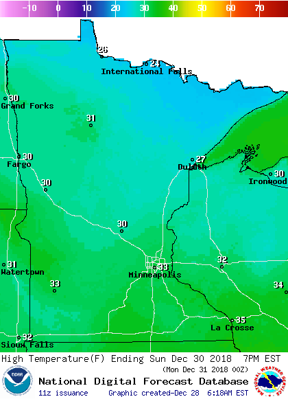
Highs rebound to the lower 30s in many areas Sunday afternoon, with some 20s in the far north.
Twin Cities metro highs are expected to reach around 26 on Monday, but only about 7 degrees on New Year’s Day. On New Year's Day of 2018 we had a high of 1 above zero in the Twin Cities.
Snow chances
Saturday looks quiet.
Northern Minnesota could see some snow showers on Sunday.
There will be a chance of snow showers across Minnesota and western Wisconsin late Sunday night and on Monday.
The National Oceanic and Atmospheric Administration’s North American Mesoscale forecast model shows the potential precipitation pattern from Sunday through Monday:

The color chart to the right of the loop refers to the strength of the signal that returns to the radar, not to the amount of snow.
As always, updated weather information can be heard on the Minnesota Public Radio Network, and you will also see updated weather info on the MPR News live weather blog.