Periods of light snow late afternoon, evening; breezy, colder on Friday
Our average high this time of year is 46 degrees in the Twin Cities metro area. We topped out at only 33 on Wednesday, and we might barely top 30 degrees in the metro area this Thursday afternoon.
There's definitely a wintry feel to our weather!
Temperature trends
Minnesota highs will be mostly in the 20s Thursday afternoon, with some lower 30s in parts of the metro area plus southeastern Minnesota. Highs in the 20s are expected statewide on Friday:
Create a More Connected Minnesota
MPR News is your trusted resource for the news you need. With your support, MPR News brings accessible, courageous journalism and authentic conversation to everyone - free of paywalls and barriers. Your gift makes a difference.

It'll be breezy on Friday too, so it'll feel really chilly.
Saturday's highs will also be in the 20s:

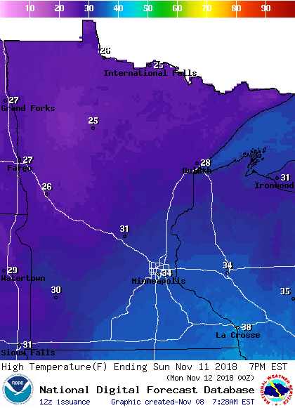
The southern half of Minnesota should see 30s on Sunday, with 20s to the north:
Looking into next week, Twin Cities metro area highs will hover around 30 degrees on Monday and Tuesday, then rise to around 37 on Wednesday. We could top 40 degrees the following weekend.
The Nov. 15 through Nov. 21 outlook from the Climate Prediction Center of the National Weather Service shows a tendency for normal to above-normal temperatures in Minnesota:

That would be a nice change from our current stretch of chilly temps.
Snow chances
Northern and central Minnesota could see a few flurries and light snow showers Thursday afternoon into Thursday night.
Snow is expected to spread from southwestern Minnesota into the remainder of southern and east-central Minnesota as we go through Thursday afternoon into Thursday evening.
The Twin Cities metro area could see a few stray flurries in the early afternoon, with periods of light snow later Thursday afternoon and Thursday evening. Metro snow accumulations are expected to be 1 inch or less, but some untreated roads could have slick spots Thursday evening.
Parts of southeastern Minnesota to western Wisconsin could see 1 to 2 inches of snow, mainly Thursday evening into the overnight hours.
A few scattered light snow showers might linger over eastern Minnesota Friday morning.
The National Oceanic and Atmospheric Administration's North American Mesoscale forecast model shows the potential snow pattern Thursday afternoon through Friday afternoon:

The color chart to the right of the loop refers to the strength of the signal that returns to the radar, not to the amount of snow.
Updated weather information can be heard on the Minnesota Public Radio Network, and you can see updated weather info on the MPR News live weather blog.
Parts of north-central Wisconsin have a winter storm warning on Friday:

They'll see plenty of snow up there:

You can check with the Duluth office of the National Weather Service for northern Minnesota and northern Wisconsin weather updates.
Programming note
You can hear my live weather updates on Minnesota Public Radio at 7:49 a.m. Thursdays and Fridays, and at 7:35 a.m., 9:35 a.m. and 4:35 p.m. each Saturday and Sunday.