Milder Saturday temps, chilly on Sunday; fall color update
Yea, it's been a chilly October.
Here's a look at October weather data from Minneapolis-St. Paul International Airport:
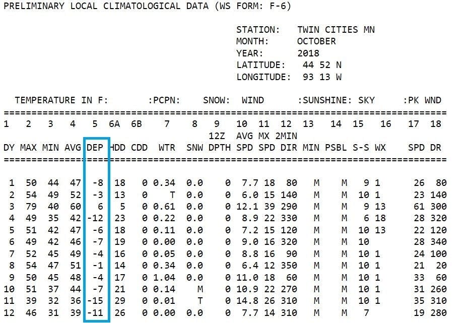
The highlighted "DEP" column shows the departure of each average daily temperature from normal. The average daily temperature is the average of each daily high temperature and low temperature.
Negative numbers in the "DEP" column indicate days that were cooler than normal, which happened on 11 out of 12 days in the Twin Cities this month.
Create a More Connected Minnesota
MPR News is your trusted resource for the news you need. With your support, MPR News brings accessible, courageous journalism and authentic conversation to everyone - free of paywalls and barriers. Your gift makes a difference.
We're overdue for some warmer temperatures!
Temperature trends
Our average Twin Cities high temperature is 60 degrees this time of year.
We're expected to top out in the 50s this Saturday afternoon. We'll share highs in the 50s with about the southern half of Minnesota. Northern Minnesota should see mostly 40s, with some upper 30s possible in the far northwest.
Cool high temps are on tap for Sunday, with 30s in northern and central Minnesota and lower 40s in the Twin Cities metro area and southern Minnesota:

Monday will also be chilly:

High temps warm nicely on Tuesday and beyond.
Twin Cities metro area highs are expected to reach around 50 Tuesday and Wednesday, followed by around 60 degrees on Thursday and Friday. One forecast model shows mid to upper 60s on Thursday....that would feel almost toasty!
Rain and snow chances
Northern Minnesota will have a chance of occasional showers as we go through Saturday, and a few spots might see a few flakes too.
Far southern Minnesota will probably see some areas of rain Saturday evening, and the Twin Cities metro area could get clipped by an isolated shower Saturday night.
On Sunday, a few snow/rain showers will be possible in northwestern and north-central Minnesota.
The National Oceanic and Atmospheric Administration’s North American Mesoscale forecast model shows the potential precipitation pattern this weekend:

The color chart to the right of the loop refers to the strength of the signal that returns to the radar, not to the amount of rain or snow.
Updated weather information can be heard on the Minnesota Public Radio Network, and you can see updated weather info on the MPR News live weather blog.
Fall colors
If you’re planning some weekend leaf-peeping in Minnesota, you’ll be interested in the latest fall color report from the Minnesota Department of Natural Resources:

Keep in mind that all deciduous trees are included in the fall color report, not just maples.
Heavy rain and strong winds earlier this week took down many leaves in some areas.
A Wisconsin fall color report is also available.
Programming note
You can hear my live weather updates on Minnesota Public Radio at 7:49 a.m. Thursdays and Fridays, and at 7:35 a.m., 9:35 a.m. and 4:35 p.m. each Saturday and Sunday.