Canal Park flood, snow up north; ‘potentially catastrophic’ Hurricane Michael
I can't remember a day with this much intense weather going on across the U.S.
Let's start along the shores of Lake Superior. The forecast of high winds and storm surge have come to pass in Duluth. Winds gusted to as high as 46 mph overnight at Bong Airport in Superior, Wis.
MPR News journalist Andrew Krueger captured significant street flooding in Canal Park Wednesday morning.
The intense wave action has tossed boulders along the boardwalk in Canal Park.
Create a More Connected Minnesota
MPR News is your trusted resource for the news you need. With your support, MPR News brings accessible, courageous journalism and authentic conversation to everyone - free of paywalls and barriers. Your gift makes a difference.
The lakeshore flood warning continues until 4 p.m. Wednesday on the Lake Superior shore. Waves as high as 14 to 18 feet will continue to pound the shoreline.

Lakeshore Hazard Message
National Weather Service Duluth MN
410 AM CDT Wed Oct 10 2018
...Lakeshore Flooding from Large Waves Today...
.Strong northeast winds will continue over western Lake Superior
through this afternoon with the potential for powerful storm-
force wind gusts to 50 knots. These winds will cause large waves
over western Lake Superior that will crash on the shoreline with
waves of 12 to 16 feet or higher. The waves could be big enough to
cause damage to the shoreline. The water level of Lake Superior
is quite high, making the shoreline more prone to getting damage
from waves.
Southern Lake/North Shore-Carlton/South St. Louis-Douglas-
Bayfield-Ashland-
410 AM CDT Wed Oct 10 2018
...LAKESHORE FLOOD WARNING REMAINS IN EFFECT UNTIL 4 PM CDT THIS
AFTERNOON...
* LAKE SHORE FLOODING...Areas of the North and South Shores of
western Lake Superior, including Two Harbors, the Duluth and
Superior areas, and Ashland.
* TIMING...Through this afternoon.
* IMPACTS...Damage is possible to shoreline infrastructure, such
as to harbors, beaches, lake walkways such as the Duluth
Lakewalk, and roads near the shore.
Snow up north
It's snowing as expected across a big chunk of eastern North Dakota and northern Minnesota. Accumulations in excess of 6 inches are likely by Thursday.

Lighter accumulations will fall in northeast Minnesota.
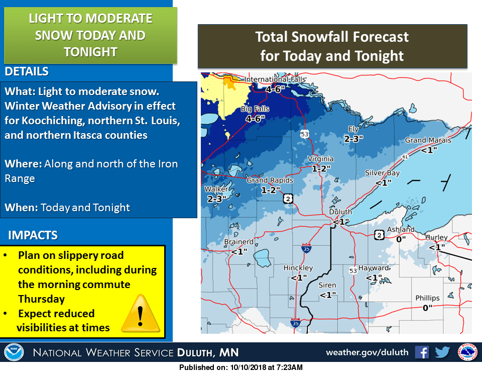
The Twin Cities will see some snowflakes flying in the hours surrounding midnight Wednesday into Thursday. Accumulations are not likely this far south. Ugh.
Cold wet fall
It's not your imagination. This has been one of the coldest, wettest, falls on record.
Twin Cities freeze
We have a good shot at the first 32-degree temperature of the season at Minneapolis-St. Paul International Airport Friday morning. Cold air sticks around through the weekend. Temperatures should moderate late next week.

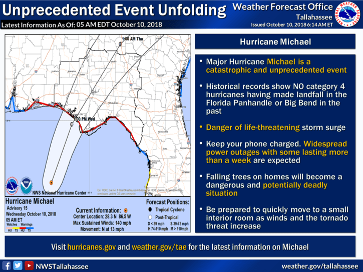
'Potentially catastrophic' Hurricane Michael
Hurricane Michael intensified as predicted last night to Category 4 status. Michael's radar presentation is just plain scary.
The National Oceanic and Atmospheric Administration's National Hurricane Center isn't pulling any punches. Warning language is about as graphic as it gets.
Michael is the strongest hurricane ever to approach the Florida panhandle region.
Storm surge is already pushing ashore.
The National Weather Service in Tallahassee, Fla., is calling this an unprecedented event for the region.