More rain for southern Minnesota Monday night and Tuesday; hot and steamy later this week
Frequent widespread rains over the past week have caused flooding across southern Minnesota, mainly in low-lying or poorly-drained areas as well as tributaries to the Minnesota River.

A mid-atmospheric low pressure system spinning across Iowa will spread more showers and thunderstorms across southern Minnesota through Tuesday. Rain will fall mainly on southwestern and south central Minnesota this Monday evening, then spread eastward into the southeastern part of the state and north into the Twin Cities area overnight. Radar has been tracking its approach:

The good news for soggy southern Minnesota as this Monday evening approaches is that forecasts have been adjusted southward a bit, decreasing the forecast rainfall amounts for that part of the state over the next 24 hours.

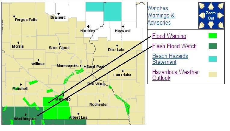
Flash flood watches for possible rapidly-rising waters remain in effect through 11 p.m. on Monday for Rock, Nobles and Jackson Counties in southwestern Minnesota. Flood warnings for already-high waters over many county roads continue for Faribault, Martin, Blue Earth and Watonwan counties in south central Minnesota.
Create a More Connected Minnesota
MPR News is your trusted resource for the news you need. With your support, MPR News brings accessible, courageous journalism and authentic conversation to everyone - free of paywalls and barriers. Your gift makes a difference.
There is a risk of severe storms into tonight, mainly well to our south in Iowa and Missouri. A marginal risk just edges across the border into Minnesota.

Rain in the longer term
As noted above, the chance of heavy rain has shifted a bit to the south. The 3-day rainfall forecast through 7 p.m. on Thursday paints a lot of rain on Iowa but much less for Minnesota:

Hot and steamy later this week
Heat and humidity will begin to kick in on Thursday and then really build on Friday. Expect high temperatures on Friday mainly from the mid 80s to the mid 90s around the state. The Twin Cities should heat to about 95. Dew points will rise into the low 70 across about the southern half of the state.
Combining the expected heat and humidity will put us into the stay-in-air-conditioning category.
More rain late in the week
An activated atmosphere could pump out some significant rain across central Minnesota from Friday through the weekend.

Severe weather this weekend?
It also looks as though we might have the potential for severe storms by the time the weekend arrives. At this early date I am most concerned that a complex of strong thunderstorms might form in northwestern Minnesota Saturday afternoon and track rapidly southeastward with strong straight-line winds. If this scenario pans out, strong or possibly severe storms could reach the Twin Cities and east central Minnesota Saturday evening. But that is just a preliminary outlook, subject to significant change.