Slow waltz into spring, minor snow chances?
It smelled like spring outside Sunday evening.
This week's weather maps continue to jog between late winter and spring mode. We heard a lot of chatter and hype over the weekend about the potential for significant snow in the Twin Cities this week.
I have to say looking at the model runs I'm not impressed with the potential for much snow in the Twin Cities Tuesday. And the notion of "significant" snow Friday night into Saturday system looks highly iffy at this point.
We start the week with a mix of sun and clouds today. Highs nudge at least the low 40s again in the Twin Cities and much of southern Minnesota Monday afternoon.
Create a More Connected Minnesota
MPR News is your trusted resource for the news you need. With your support, MPR News brings accessible, courageous journalism and authentic conversation to everyone - free of paywalls and barriers. Your gift makes a difference.
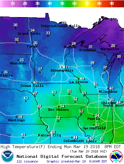
More 40s ahead
Tuesday looks like the coolest day this week with highs in the 30s. But there are significant model temperature differences this week. To me, the National Oceanic and Atmospheric Administration's National Digital Forecast Database numbers for Minneapolis below look a few degrees conservative this week.
Temps could approach 50 again across southern Minnesota Thursday.

Here's NOAA's Global Forecast System output. Closer to 50 Thursday?

Tuesday: Frontolosys
frontolysis - The dissipation of a front or frontal zone. - AMS glossary
A fading frontal system nudges east into Minnesota Tuesday. The system will produce some snow accumulations in the Dakotas and western Minnesota. But the low will be running out of gas by the time it makes the Twin Cities.
NOAA's North American Mesoscale Forecast System 3 km resolution model captures the evolution of the sputtering system as it moves east into Minnesota Tuesday.

Western Minnesota may pick up a slushy inch or two. A slushy coating at best looks like the most likely outcome for the Twin Cities overnight into Tuesday.

Weekend system: Rain or snow?
Model trends for next weekend suggest a mixed rain to snow system Friday night into Saturday. It's still too early to be sure, but trends have been pulling back from the notion of heavy snow in favor of more rain. The Canadian model has done well with systems this past winter.
NOAA's GFS and the European Centre for Medium-Range Weather Forecasts suggest a rain/snow mix. For now, both the European Centre model and GFS have backed off the notion of potentially heavy snow next weekend.
Stay tuned.