Major winter storm is arriving
A major winter storm that will disrupt travel and close schools today is on our doorstep. Early this Monday morning, rain and mixed precipitation are falling in south-central and southeastern Minnesota while wet snow is beginning to fall in the southwestern part of the state.
Heavy, wet snow will develop across southern and east-central Minnesota this morning. And the wind will pick up.
Blizzard
"Blizzard" is a word that commands attention. A blizzard warning continues for the rest of today for much of south-central and southwestern Minnesota. Areas included so far are Brown, Watonwan, Blue Earth, Martin and Faribault counties -- that is, the area from Mankato to points south and southwest. That area should expect whiteout conditions at times today.
Create a More Connected Minnesota
MPR News is your trusted resource for the news you need. With your support, MPR News brings accessible, courageous journalism and authentic conversation to everyone - free of paywalls and barriers. Your gift makes a difference.

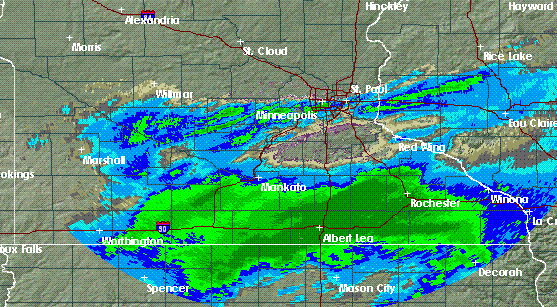
Heavy, wet snow on the way
Heavy snow will expand northeastward throughout Monday, so a large area of winter storm warnings, as shown above in pink, have been posted from Minnesota well into Wisconsin.
By the time the snow winds down Monday night, a foot or more of snow will have fallen on much of the warned area.

The Twin Cities metro area will be right on an unusually-sharp northwestern edge of this storm. While Farmington in the southeast metro might get a solid foot of snow, some northwestern suburbs might struggle to get a couple inches. The inner core areas of Minneapolis and St. Paul are likely to get something around half a foot. Of course, these specific amounts can change greatly if the storm shifts its track just a bit.
I will be doing extra weather broadcasts on MPR this morning and will post an expanded Updraft blog as time permits.