Arctic cold weekend; dangerous wind chills
Meteorologists are running out of ways to say "cold".
Arctic cold temps will be with us this weekend and through New Year's Day.
It's a good thing that the Vikings game isn't outdoors on Sunday!
Temperatures take a dive
Create a More Connected Minnesota
MPR News is your trusted resource for the news you need. With your support, MPR News brings accessible, courageous journalism and authentic conversation to everyone - free of paywalls and barriers. Your gift makes a difference.
Colder air will spread over Minnesota Friday night and linger into Monday.
Saturday will dawn with temps in the 20s below zero over much of northern Minnesota, and teens below zero in the south.
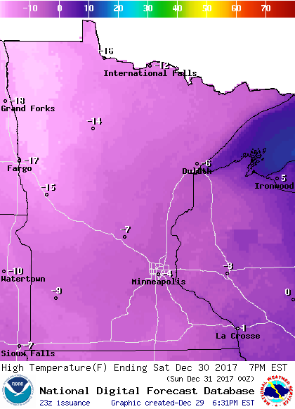
Saturday highs will be below zero statewide:
Similar highs are expected on Sunday.
Sunday morning low temps could dipped to 30 below zero in parts of northern Minnesota:

Our New Year's Day high temps are expected to be within a couple of degrees of zero over much of Minnesota.
Dangerous wind chills
There will be enough wind to create dangerous wind chills this weekend.
In the following graphic, "tonight" refers to Friday night into early Saturday:

Wind chill warnings indicate wind chill temps in the -25 to -50 range over northern and western Minnesota and parts of central Minnesota.
Details of the wind chill warning in northern Minnesota from Friday evening into Monday:
URGENT - WINTER WEATHER MESSAGE
National Weather Service Duluth MN
230 PM CST Fri Dec 29 2017
MNZ010>012-018-019-025-026-033>036-300830-
/O.CON.KDLH.WC.W.0003.171230T0300Z-180101T1500Z/
Koochiching-North St. Louis-Northern Cook/Northern Lake-
North Itasca-Central St. Louis-North Cass-South Itasca-South Cass-
Crow Wing-Northern Aitkin-South Aitkin-
Including the cities of International Falls, Ely, Isabella,
Bigfork, Hibbing, Walker, Grand Rapids, Pine River, Brainerd,
Hill City, and Aitkin
230 PM CST Fri Dec 29 2017
...WIND CHILL WARNING REMAINS IN EFFECT FROM 9 PM THIS EVENING TO
9 AM CST MONDAY...
* WHAT...Dangerously cold wind chills expected. The dangerously
cold wind chills will cause frostbite to exposed skin in as
little as 10 minutes. Expect wind chills to range from 25 below
zero to 45 below zero this weekend.
* WHERE...Portions of east central, north central and northeast
Minnesota.
* WHEN...From 9 PM this evening to 9 AM CST Monday.
PRECAUTIONARY/PREPAREDNESS ACTIONS...
A Wind Chill Warning means the combination of very cold air and
the wind will create dangerously low wind chill values. Frostbite
can occur quickly and even hypothermia or death if precautions
are not taken.
Frostbite can occur on exposed skin in 10 minutes or less with wind chill temps like this.
Warm clothes and a charged cell phone are precautions to take before venturing out on a trip this weekend.
The Twin Cities metro area and southeastern Minnesota are under a wind chill advisory for -20 to -35 wind chills this weekend:
URGENT - WINTER WEATHER MESSAGE
National Weather Service Twin Cities/Chanhassen MN
237 PM CST Fri Dec 29 2017
...An Arctic Outbreak with Dangerously Cold Wind Chills
Developing...
.The coldest air of the season will surge southward tonight, and
last through Sunday. Temperatures will continue fall well below
zero by Saturday morning. As northwest winds increase this
evening, wind chill values will drop into the 25 to 45 degree
below zero range. Although these dangerously cold wind chills
will abate some Saturday afternoon as temperatures rise, the added
affect of gusty winds at times, will lead to the continuation of
wind chill values between 20 to 35 below zero Saturday afternoon.
Thus, the wind chill warnings and advisories across portions of
central, southern Minnesota, as well as west central Wisconsin
will continue through Sunday morning.
The wind chill warning is for areas west of a line from Mora, to
Buffalo, Mankato and Blue Earth Minnesota. A wind chill advisory
is for areas east of this line which includes the Twin Cities
Metro area, and portions of south central Minnesota, as well as
west central Wisconsin.
MNZ045-052-053-060>063-068>070-076>078-084-085-093-WIZ014>016-
023>028-300500-
/O.NEW.KMPX.WC.Y.0008.171230T0900Z-171231T1800Z/
Kanabec-Isanti-Chisago-Hennepin-Anoka-Ramsey-Washington-Carver-
Scott-Dakota-Le Sueur-Rice-Goodhue-Waseca-Steele-Freeborn-Polk-
Barron-Rusk-St. Croix-Pierce-Dunn-Pepin-Chippewa-Eau Claire-
Including the cities of Mora, Cambridge, Center City,
Minneapolis, Blaine, St Paul, Stillwater, Chaska, Shakopee,
Hastings, Le Sueur, Faribault, Red Wing, Waseca, Owatonna,
Albert Lea, Osceola, Rice Lake, Ladysmith, Hudson, River Falls,
Prescott, Menomonie, Durand, Chippewa Falls, and Eau Claire
237 PM CST Fri Dec 29 2017
...WIND CHILL ADVISORY IN EFFECT FROM 3 AM SATURDAY TO NOON CST
SUNDAY...
* WHAT...Very cold wind chills expected. The cold wind chills
will cause frostbite in as little as 30 minutes to exposed
skin. Expect wind chills to range from 20 below zero to 35
below zero.ron gtre
* WHERE...Portions of northwest and west central Wisconsin and
east central, south central and southeast Minnesota.
* WHEN...From 3 AM Saturday to noon CST Sunday.
* ADDITIONAL DETAILS...If you are venturing outside this weekend,
please remember to dress in layers as any exposed skin will
develop frostbite in a very short period of time.
PRECAUTIONARY/PREPAREDNESS ACTIONS...
A Wind Chill Advisory means that cold air and the wind will
combine to create low wind chills. Frost bite and hypothermia can
occur if precautions are not taken. Make sure you wear a hat and
gloves.
Mostly snow-free this weekend
With arctic high pressure sprawled across the upper Midwest, most of Minnesota will not see any snow this weekend or on New Year's Day.
The exception will be southwestern and south-central Minnesota, where some flakes are possible Saturday evening and Saturday night.
The National Oceanic and Atmospheric Administration’s Global Forecast System model shows the potential snow pattern this weekend and New Year's Day:

The color chart to the right of the loop refers to the precipitation rate (mm per hour), not to the total amount of snow.
Happy New Year!
A nice way to approach the end of 2017:
Programming note
You can hear my live weather updates on Minnesota Public Radio at 7:49 a.m. Thursdays and Fridays, and at 7:35 a.m., 9:35 a.m. and 4:35 p.m. each Saturday and Sunday.