Irma’s fierce winds and flooding; quiet Monday in Minnesota
Powerful Hurricane Irma spread destructive winds, dangerous storm surges and heavy rain over much of Florida on Sunday.

Irma's first Florida landfall was at 9:10 a.m. EDT in the Florida Keys:
Hurricane Irma made a second Florida landfall Sunday afternoon, at Marco Island on Florida's southwest coast:
From there, Irma moved toward Naples, where a gust of 142 mph was reported:
Create a More Connected Minnesota
MPR News is your trusted resource for the news you need. With your support, MPR News brings accessible, courageous journalism and authentic conversation to everyone - free of paywalls and barriers. Your gift makes a difference.
Hurricane force winds extended 80 miles from Irma's center Sunday afternoon, so the damaging winds spread across much of Florida.
The center of Irma will move north-northwestward near or over the west coast of the Florida peninsula Sunday night and Monday morning, according to the Sunday evening update from the National Hurricane Center:

On Monday afternoon, Irma moves from north Florida into southwest Georgia as a tropical storm.
More details, from the Sunday evening NHC update:
BULLETIN
Hurricane Irma Intermediate Advisory Number 47A
NWS National Hurricane Center Miami FL AL112017
800 PM EDT Sun Sep 10 2017
...IRMA MOVING NORTHWARD NEAR FT. MYERS...
...DANGEROUS STORM SURGES EXPECTED IN AREAS OF ONSHORE WINDS ALONG
THE FLORIDA WEST COAST...
SUMMARY OF 800 PM EDT...0000 UTC...INFORMATION
----------------------------------------------
LOCATION...26.7N 81.7W
ABOUT 15 MI...25 KM ENE OF FT. MYERS FLORIDA
ABOUT 30 MI...50 KM SE OF PORT CHARLOTTE FLORIDA
MAXIMUM SUSTAINED WINDS...105 MPH...165 KM/H
PRESENT MOVEMENT...N OR 355 DEGREES AT 14 MPH...22 KM/H
MINIMUM CENTRAL PRESSURE...942 MB...27.82 INCHES
WATCHES AND WARNINGS
--------------------
CHANGES WITH THIS ADVISORY:
None.
SUMMARY OF WATCHES AND WARNINGS IN EFFECT:
A Storm Surge Warning is in effect for...
* South Santee River southward to Jupiter Inlet
* North Miami Beach southward around the Florida peninsula to the
Ochlockonee River
* Florida Keys
* Tampa Bay
A Hurricane Warning is in effect for...
* Fernandina Beach southward around the Florida peninsula to Indian
Pass
* Florida Keys
* Lake Okeechobee
* Florida Bay
A Hurricane Watch is in effect for...
* North of Fernandina Beach to Edisto Beach
A Tropical Storm Warning is in effect for...
* West of Indian Pass to the Okaloosa/Walton County Line
* North of Fernandina Beach to South Santee River
A Tropical Storm Warning is in effect for...
* Bimini and Grand Bahama
A Storm Surge Warning means there is a danger of life-threatening
inundation, from rising water moving inland from the coastline,
during the next 36 hours in the indicated locations. For a
depiction of areas at risk, please see the National Weather
Service Storm Surge Watch/Warning Graphic, available at
hurricanes.gov. This is a life-threatening situation. Persons
located within these areas should take all necessary actions to
protect life and property from rising water and the potential for
other dangerous conditions. Promptly follow evacuation and other
instructions from local officials.
Interests elsewhere in the southeastern United States should monitor
the progress of Irma.
For storm information specific to your area in the United States,
including possible inland watches and warnings, please monitor
products issued by your local National Weather Service forecast
office. For storm information specific to your area outside the
United States, please monitor products issued by your national
meteorological service.
DISCUSSION AND 48-HOUR OUTLOOK
------------------------------
At 800 PM EDT (0000 UTC), the center of Hurricane Irma was located
by NOAA Doppler radar near latitude 26.7 North, longitude 81.7 West.
Irma is moving toward the north near 14 mph (22 km/h), and a
north-northwestward motion with an increase in forward speed is
expected by tonight, with that motion continuing through Monday. On
the forecast track, the eye of Irma should move near or over the
west coast of the Florida Peninsula through Monday morning. Irma
should then move inland over northern Florida and southwestern
Georgia Monday afternoon.
Maximum sustained winds have decreased to near 105 mph (165 km/h)
with higher gusts. Although weakening is forecast, Irma is expected
to remain a hurricane at least through Monday morning.
Hurricane-force winds extend outward up to 80 miles (130 km) from
the center, and tropical-storm-force winds extend outward up to 220
miles (350 km).
The estimated minimum central pressure is 942 mb (27.82 inches).
HAZARDS AFFECTING LAND
----------------------
STORM SURGE: The combination of a dangerous storm surge and the
tide will cause normally dry areas near the coast to be flooded by
rising waters moving inland from the shoreline. The water is
expected to reach the following HEIGHTS ABOVE GROUND if the peak
surge occurs at the time of high tide...
Cape Sable to Captiva...10 to 15 ft
Captiva to Ana Maria Island...6 to 10 ft
Card Sound Bridge through Cape Sable, including the Florida Keys...
5 to 10 ft
Anna Maria Island to Clearwater Beach, including Tampa Bay...
5 to 8 ft
North Miami Beach to Card Sound Bridge, including Biscayne Bay...
3 to 5 ft
South Santee River to Fernandina Beach...4 to 6 ft
Clearwater Beach to Ochlockonee River...4 to 6 ft
Fernandina Beach to Jupiter Inlet...3 to 5 ft
North of North Miami Beach to Jupiter Inlet...1 to 2 ft
The deepest water will occur along the immediate coast in areas of
onshore winds, where the surge will be accompanied by large and
destructive waves. Surge-related flooding depends on the relative
timing of the surge and the tidal cycle, and can vary greatly over
short distances. For information specific to your area, please see
products issued by your local National Weather Service forecast
office.
WIND: Hurricane conditions are continuing across portions of the
southern Florida peninsula. Winds affecting the upper floors of
high-rise buildings will be significantly stronger than those near
ground level. Tropical storm and hurricane conditions are expected
to spread northward across the remainder of the warning areas
through Monday. Tropical storm conditions are expected in portions
of the warning area in the Northwestern Bahamas this evening.
RAINFALL: Irma is expected to produce the following rain
accumulations through Wednesday:
Western Bahamas...Additional 2 to 4 inches, isolated 6 inches.
The Florida Keys...Additional 3 to 6 inches with storm total amounts
from 15 to 20 inches, isolated 25 inches.
Western Florida peninsula...10 to 15 inches, isolated 20 inches.
Eastern Florida peninsula and southeast Georgia...8 to 12 inches,
isolated 16 inches.
The rest of Georgia, the eastern Florida Panhandle, southern and
western South Carolina, and western North Carolina...3 to 8 inches,
isolated 12 inches.
Southern Tennessee, northern Mississippi and much of Alabama...2 to
5 inches.
In all areas this rainfall may cause life-threatening flash floods.
TORNADOES: Tornadoes remain possible through tonight, mainly across
central and eastern portions of the Florida Peninsula and extreme
southeast Georgia.
THE EYE: Do not venture outside when the calm eye of the hurricane
passes over, as dangerous winds will return very quickly when the
eye moves away.
SURF: Swells generated by Irma are affecting the southeast coast of
the United States. These swells are likely to cause life-
threatening surf and rip current conditions. Please consult
products from your local weather office.
NEXT ADVISORY
-------------
Next complete advisory at 1100 PM EDT.
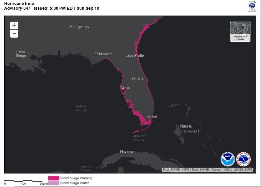
As of Sunday evening, almost all of Florida remained in a hurricane warning.
Also, storm surge warnings remained in effect along much of Florida coastline and northward to South Carolina:
More on Irma
This is a mosaic of NWS radars from Sunday afternoon:

Irma's wind and rain in Fort Myers Sunday evening:
Although missed by Irma's strongest winds, Miami had hurricane force wind gusts and flooding:
The number of Florida power outages is expected to rise:
On the lighter side:
Nice Monday for Minnesota
Most of Minnesota will have a dry Monday, and many spots in central and southern Minnesota will top 80 degrees Monday afternoon:

The Twin Cities metro area is expected to see highs in the lower 80s Monday through Thursday, then upper 70s on Friday.
The Twin Cities average high temp drops to 73 degrees by September 12.
Programming note
You can hear my live weather updates on Minnesota Public Radio at 7:49 a.m. Thursdays and Fridays, and at 7:35 a.m., 9:35 a.m. and 4:35 p.m. each Saturday and Sunday.