Growing odds for devastating mainland U.S. Irma landfall
Today's updated forecast tracks for Hurricane Irma give me a sick feeling in my stomach. Florida and/or the southeast U.S. are now increasingly likely to suffer a direct hit from this major, already historic hurricane.
Heavy damage already
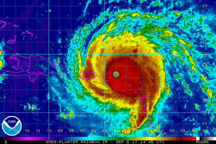
Irma has already produced massive destruction with a direct hit on several Caribbean islands. The Prime Minister for Barbuda says 90% of the island is destroyed.
https://twitter.com/ldobsonhughes/status/905528133092335616
Create a More Connected Minnesota
MPR News is your trusted resource for the news you need. With your support, MPR News brings accessible, courageous journalism and authentic conversation to everyone - free of paywalls and barriers. Your gift makes a difference.
Intense video from St. Martin shows extensive damage there.
Intensity forecast: Warm water ahead
All meteorological markers for Irma suggest she will likely maintain, or even intensify further in the next 24 to 48 hours. Irma is forecast to cross over a very warm bubble of water between Cuba and Florida. Water temperatures there are as warm as 88 degrees. That's incredibly high octane fuel for a hurricane like Irma.
Forecast track: Florida in danger
There's just no way to sugar coat Irma's projected path. Yes, there is still uncertainty. But both the offical track from NOAA's National Hurricane Center and the often trusty European Model (ECMWF) take Irma's center right over Key Largo, Miami and West Palm Beach Sunday. And the Georgia/South Carolina coasts are also in the offical path.
Here's the latest European model track. Again, a devastating scenario for Miami and Florida's east coast.

Growing odds for a direct hit
Yes, the current forecast may still change. And yes, we tell people to focus on the wider cone of uncertainty. Irma is a big storm and impacts will be widespread. But let's get real here. It matters precisely where the eyewall hits. If that track verifies it will be a worst case scenario for the Miami area and Florida's heavily populated and pricey east coast.
Millions of our fellow citizens are in harm's way this weekend. We should all be pulling for efficient evacuations and safe shelter for everyone in Irma's path.
We don't know what this is going to look like by next Monday.