Florida braces for Irma
Hurricane Irma is a major (Category 4) hurricane this Saturday morning, with maximum sustained winds of 130 mph.
Irma moved along the north coast of Cuba Friday night:

Irma is expected to turn toward the Florida Keys late Saturday, and is likely to strengthen a bit as it passes over the warm water between the Florida Keys and Cuba.
Hurricane force winds currently extend about 70 miles out from the center of Irma.
Create a More Connected Minnesota
MPR News is your trusted resource for the news you need. With your support, MPR News brings accessible, courageous journalism and authentic conversation to everyone - free of paywalls and barriers. Your gift makes a difference.
Here's the Saturday morning update on Irma's forecast track, from the National Hurricane Center:

Details of the Saturday morning update from the NHC:
BULLETIN
Hurricane Irma Intermediate Advisory Number 41A
NWS National Hurricane Center Miami FL AL112017
800 AM EDT Sat Sep 09 2017
...HURRICANE IRMA HITTING HARD THE NORTH COAST OF CUBA...
...TERRAIN OF CUBA WEAKEN THE HURRICANE BUT RESTRENGTHENING IS
ANTICIPATED...
SUMMARY OF 800 AM EDT...1200 UTC...INFORMATION
----------------------------------------------
LOCATION...22.6N 79.6W
ABOUT 10 MI...15 KM NW OF CAIBARIEN CUBA
ABOUT 225 MI...365 KM S OF MIAMI FLORIDA
MAXIMUM SUSTAINED WINDS...130 MPH...215 KM/H
PRESENT MOVEMENT...WNW OR 275 DEGREES AT 12 MPH...19 KM/H
MINIMUM CENTRAL PRESSURE...937 MB...27.67 INCHES
WATCHES AND WARNINGS
--------------------
CHANGES WITH THIS ADVISORY:
The Hurricane Warning for the Central Bahamas and the Ragged
Island has been discontinued.
Additional Watches and Warnings may be required for portions of the
coasts of Georgia and South Carolina, as well as portions of the
Florida Gulf Coast later today.
SUMMARY OF WATCHES AND WARNINGS IN EFFECT:
A Storm Surge Warning is in effect for...
* Volusia/Brevard County Line southward around the Florida peninsula
to Chassahowitzka
* Florida Keys
* Tampa Bay
A Storm Surge Watch is in effect for...
* North of the Volusia/Brevard County Line to the Flagler/Volusia
County line
* North of Chassahowitzka to Suwannee River
A Hurricane Warning is in effect for...
* Flagler/Volusia County Line southward around the Florida peninsula
to Chassahowitzka
* Florida Keys
* Lake Okeechobee
* Florida Bay
* Cuban provinces of Camaguey, Ciego de Avila, Sancti Spiritus,
Villa Clara, and Matanzas
* Northwestern Bahamas
A Hurricane Watch is in effect for...
* North of the Flagler/Volusia County Line to Fernandina Beach
* North and west of Chassahowitzka to Indian Pass
* Cuban provinces of Holguin and Las Tunas
A Tropical Storm Warning is in effect for...
* Cuban provinces of Holguin, Las Tunas, La Habana, and Ciudad de
la Habana
A Tropical Storm Watch is in effect for...
* North of Fernandina Beach to Altamaha Sound
A Storm Surge Warning means there is a danger of life-threatening
inundation, from rising water moving inland from the coastline,
during the next 36 hours in the indicated locations. For a
depiction of areas at risk, please see the National Weather
Service Storm Surge Watch/Warning Graphic, available at
hurricanes.gov. This is a life-threatening situation. Persons
located within these areas should take all necessary actions to
protect life and property from rising water and the potential for
other dangerous conditions. Promptly follow evacuation and other
instructions from local officials.
A Storm Surge Watch means there is a possibility of life-
threatening inundation, from rising water moving inland from the
coastline, in the indicated locations during the next 48 hours.
For a depiction of areas at risk, please see the National Weather
Service Storm Surge Watch/Warning Graphic, available at
hurricanes.gov.
A Hurricane Warning means that hurricane conditions are expected
somewhere within the warning area. Preparations to protect life and
property should be rushed to completion.
A Hurricane Watch means that hurricane conditions are possible
within the watch area. A watch is typically issued 48 hours
before the anticipated first occurrence of tropical-storm-force
winds, conditions that make outside preparations difficult or
dangerous.
A Tropical Storm Warning means that tropical storm conditions are
expected somewhere within the warning area.
A Tropical Storm Watch means that tropical storm conditions are
possible within the watch area, generally within 48 hours.
Interests elsewhere in Cuba, Florida, and the southeastern United
States should monitor the progress of Irma.
For storm information specific to your area in the United States,
including possible inland watches and warnings, please monitor
products issued by your local National Weather Service forecast
office. For storm information specific to your area outside
the United States, please monitor products issued by your national
meteorological service.
DISCUSSION AND 48-HOUR OUTLOOK
------------------------------
At 800 AM EDT (1200 UTC), the eye of Hurricane Irma was located by a
reconnaissance plane and Cuban radars near latitude 22.6 North,
longitude 79.5 West. Irma is moving toward the west near 12 mph (19
km/h), along the north coast of Cuba. A northwest motion is expected
to begin later today with a turn toward the north-northwest tonight
or on Sunday. On the forecast track, the core of Irma will continue
to move near or over the north coast of Cuba this morning, and will
reach the Florida Keys Sunday morning. The hurricane is expected to
be near the southwest coast of Florida Sunday afternoon.
The interaction with the terrain of Cuba has weakened the hurricane
a little. Maximum sustained winds have decreased to near 130 mph
(215 km/h) with higher gusts, but Irma remains a category 4
hurricane on the Saffir-Simpson Hurricane Wind Scale. Irma is
forecast to restrengthen once it moves away from Cuba, and Irma is
expected to remain a powerful hurricane as it approaches Florida.
Hurricane-force winds extend outward up to 70 miles (110 km) from
the center and tropical-storm-force winds extend outward up to 195
miles (315 km).
The minimum central pressure reported by a reconnaissance plane
was 937 mb (27.67 inches).
HAZARDS AFFECTING LAND
----------------------
STORM SURGE: The combination of a dangerous storm surge and the
tide will cause normally dry areas near the coast to be flooded by
rising waters moving inland from the shoreline. The water is
expected to reach the following HEIGHTS ABOVE GROUND if the peak
surge occurs at the time of high tide...
SW Florida from Captiva to Cape Sable...8 to 12 ft
Cape Sable to Boca Raton including the Florida Keys...5 to 10 ft
Venice to Captiva...5 to 8 ft
Suwannee River to Venice including Tampa Bay...3 to 5 ft
Boca Raton to Flagler/Volusia County line...2 to 4 ft
The deepest water will occur along the immediate coast in areas of
onshore winds, where the surge will be accompanied by large and
destructive waves. Surge-related flooding depends on the relative
timing of the surge and the tidal cycle, and can vary greatly over
short distances. For information specific to your area, please see
products issued by your local National Weather Service forecast
office.
The combination of a life-threatening storm surge and large breaking
waves will raise water levels ABOVE NORMAL TIDE LEVELS by the
following amounts within the hurricane warning area near and to the
north of the center of Irma. Near the coast, the surge will be
accompanied by large and destructive waves.
Ragged Island in the Bahamas...15 to 20 ft
Central and Northwestern Bahamas...3 to 6 ft
Northern coast of Cuba in the warning area...5 to 10 ft
WIND: Hurricane conditions are expected to continue within the
hurricane warning area along the north coast of Cuba through today.
Hurricane conditions are expected in the northwestern Bahamas today,
and in portions of southern and central Florida and the Florida Keys
tonight and Sunday.
Hurricane and tropical storm conditions are possible within the
watch area in central and north Florida by Sunday.
RAINFALL: Irma is expected to produce the following rain
accumulations through Tuesday night:
Northern Cuba...10 to 15 inches, isolated 20 inches. Southern
Cuba...5 to 10 inches, isolated 15 inches.
Western Bahamas...3 to 6 inches, isolated 10 inches.
The Florida Keys...10 to 20 inches, isolated 25 inches.
The Florida peninsula and southeast Georgia...8 to 15 inches,
isolated 20 inches.
The eastern Florida Panhandle...3 to 6 inches, isolated 8 inches.
Rest of eastern Georgia, western South Carolina, and western North
Carolina...4 to 8 inches. Western Georgia, eastern and northern
Alabama, and southern Tennessee...2 to 5 inches.
In all areas this rainfall may cause life-threatening flash floods
and, in some areas, mudslides.
TORNADOES: A few tornadoes are possible today and tonight over
southern Florida.
SURF: Swells generated by Irma are affecting the southeastern
Bahamas, the Turks and Caicos Islands and the southeast coast of the
United States today. These swells are likely to cause
life-threatening surf and rip current conditions. Please consult
products from your local weather office.
NEXT ADVISORY
-------------
Next complete advisory at 1100 AM EDT.
Hurricane warnings extend from the Florida Keys through most of south Florida and central Florida.
Much of south Florida is also under a storm surge warning:

The storm surge warning includes the Tampa area and even some areas north of Tampa:

Pleasant weekend for Minnesota
Our weekend weather will be enjoyable in Minnesota.
Saturday highs will be mostly in the 70s, with some 60s in the northeast.
A few scattered showers and an isolated thunderstorm are possible in west-central and southwestern Minnesota Saturday night.
Highs Sunday will reach the lower 80s in southern Minnesota:
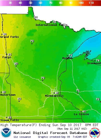
70s will be common elsewhere.
The Twin Cities metro area could see lower 80s Sunday through Thursday, then upper 70s on Friday.
Programming note
You can hear my live weather updates on Minnesota Public Radio at 7:49 a.m. Thursdays and Fridays, and at 7:35 a.m., 9:35 a.m. and 4:35 p.m. each Saturday and Sunday.