Sirens will sound twice today; it’s a drill
This is Severe Weather Awareness week in Minnesota and Wisconsin.
Today's severe weather topic is tornado preparedness.
Minnesota and Wisconsin National Weather Service offices will issue simulated tornado warnings at 1:45 p.m. and at 6:45 p.m. today.
Most Minnesota and Wisconsin cities and counties will sound their severe weather sirens as part of the tornado drills.
Create a More Connected Minnesota
MPR News is your trusted resource for the news you need. With your support, MPR News brings accessible, courageous journalism and authentic conversation to everyone - free of paywalls and barriers. Your gift makes a difference.
When the sirens sound today, think of where you would go and what you would do if it was a real tornado warning.
Here are some tornado safety tips from the NWS:
Before the Tornado...
Tornado watches highlight the area where tornadoes are most likely to develop. Continue with your normal activites, but keep informed of the latest weather information and be ready to get to shelter in case tornadoes develop quickly.
In the Home...
Go to the basement if possible. Get under a table, work bench, or some other sturdy furniture to avoid falling debris. A stairwell is also a good place to hide during a tornado.
If You Cannot Get to a Basement...
Go to a small interior room on the lowest floor. Closets, bathrooms, and interior halls afford the best protection in most cases, or try to hide under a bed. Get under something sturdy or cover yourself with blankets. Stay away from windows.
In an Apartment, School or Office Building...
Move to the inner-most room on the lowest level or to a pre-designated shelter area. Stay away from windows. If in a hallway, crouch down and protect your head from flying debris. Avoid areas with glass and large roof expansions.
In a Mobile Home, Car, Truck or Other Vehicle...
Abandon these as quickly as possible. Seek a sturdy shelter or permanent structure. Remember that many deaths occur when people try to drive away in a vehicle, but get caught in the deadly winds. Avoid bridges since they act as wind tunnels.
Tornado sirens were never intended to warn people who are indoors. Many people won't hear a warning siren if their windows are closed.
Minnesota Public Radio relays severe weather warnings from the National Weather Service, and MPR meteorologists provide you with additional severe weather information.
The best way to be alerted to severe weather when you aren't monitoring local broadcasts is with a NOAA weather radio.
According to the NWS:
NOAA Weather Radio...
The tone alert feature of NOAA Weather Radio will activate specially built receivers, sounding an alarm to alert you to the danger. It sounds its alert anytime the National Weather Service issues a warning, even in the middle of the night. Make sure you have a NOAA Weather Radio, as you can not always depend on sirens, phone calls or seeing the warnings on television.
Most models of NOAA weather radios allow you to program the radios to activate only for warnings in a single county or in a small set of counties.
Gray again
Most Minnesotan's won't need their sunglasses today. Periods of mostly rain will linger over north-central and northeastern Minnesota into this Thursday afternoon. The higher elevations along the north shore of Lake Superior could see 1 to 3 inches of snow.
Parts of Duluth have seen some snow this Thursday morning, but it was much snowier in Duluth during April of 2013:
Duluth saw 50.8 inches of snow during April of 2013!
Central Minnesota and the Twin Cities metro area could see some scattered showers and periods of drizzle today.
We're expecting some welcome sunshine on Friday and Saturday.
Sunday will be mostly sunny in southern Minnesota, with a chance of showers in the north.
Rain returns
Minnesota will have of chance of occasional showers this coming week, especially late Monday into Tuesday and Wednesday.
The National Oceanic and Atmospheric Administration’s Global Forecast System model shows the potential precipitation pattern:

Northeastern Minnesota could see a mix of rain and snow.
The color chart to the right of the loop refers to the potential precipitation rate, not the total amount of rain or snow.
Temps rebound
After a cool Thursday, Friday's highs rebound into the 50s with some spots in southern Minnesota touching 60:
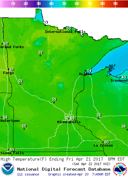
Our average high temperature in the Twin Cities rises to 61 degrees by tomorrow.
Widespread 60s are expected on Saturday:

Northern Minnesota will see cooler highs return on Sunday, but 60s will be common in southern Minnesota:

Programming note
You can hear my live weather updates on Minnesota Public Radio at 7:49 a.m. Thursdays and Fridays, and at 7:35 and 9:35 a.m., plus 4:35 p.m., each Saturday and Sunday.