In spite of snow, metrics show an early spring
Better late than never?
Monday evening's snow burst was localized but intense in places. Many Twin Cities locations reported 2-inch snowfall totals on grassy areas. One trained spotter in North Branch along Interstate 35 north of the Twin Cities measured an incredible 7.5 inches of fluff.
2 NNE North Branch [Chisago Co, MN] TRAINED SPOTTER reports SNOW of 7.50 INCH at 7:25 AM CDT --
Keep in mind April snowfall is typical for the Twin Cities. Minneapolis-St. Paul International Airport averages 2.4 inches of snow in April.
Create a More Connected Minnesota
MPR News is your trusted resource for the news you need. With your support, MPR News brings accessible, courageous journalism and authentic conversation to everyone - free of paywalls and barriers. Your gift makes a difference.
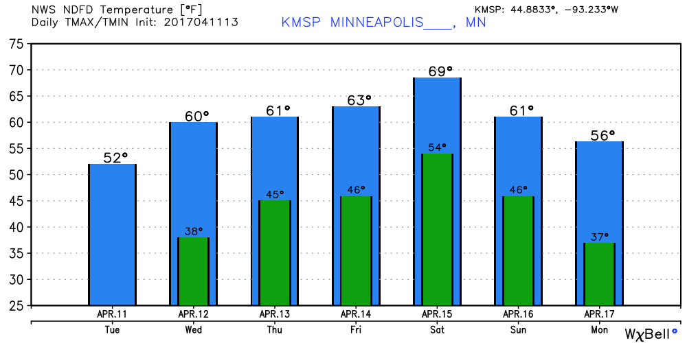
Sun returns
We now return you to your regular springtime weather programming.
Sunshine returns to Minnesota from west to east today. The growing intensity of our rising April sun angle means a snowy disappearing act today. Temps rebound into the 50s today, and 60s the rest of the week.
Wednesday night rain?
The next low-pressure waves ride in Wednesday evening and Friday night into Saturday. Pick your sunny spots in between today, Thursday, and Sunday.

Several models suggest 1- to 2-inch rainfall totals by early next week across southern Minnesota, with less up north. That should speed up the spring green-up if it verifies.

Early spring
Phenologists track the progress of spring by recording the first leaves and blooms. According to that metric, spring is running about 10-20 days early across Minnesota and much of the nation.

Here's more detail from the National Phenology Network.
In 2017, we see very large anomalies in the southeastern United States on the Spring Leaf Index map, where the Index was met up to three weeks earlier than what is typical (1981-2010) for these locations.
The timing of leaf-out, migration, flowering and other seasonal phenomena in many species is closely tied to local weather conditions and broad climatic patterns. The Spring Index maps offered by USA-NPN shed light on plant and animal phenology, based on local weather and climate conditions.
April: 20th warm month in a row for MSP?
Believe it or not, April is running 8.1 degrees warmer than average at MSP Airport even with Monday's bonus snow. Looking at the medium-range maps for the next two to three weeks, I assess April will go down as the 20th straight warmer than average month in the Twin Cities and most of Minnesota. Our unprecedented string of warm months continues.

Tornado sirens hacked in Dallas
Dallas got a rude awakening Friday night. Clearly there are ways to hack the sirens. Let's hope this is an isolated incident.
March for Science Saturday
The death of coal?
The quote from Xcel Energy's CEO caught my eye. As renewables prove to be a more cost-effective way to produce clean energy, many wonder if a return to coal is even realistic.
Emissions drop