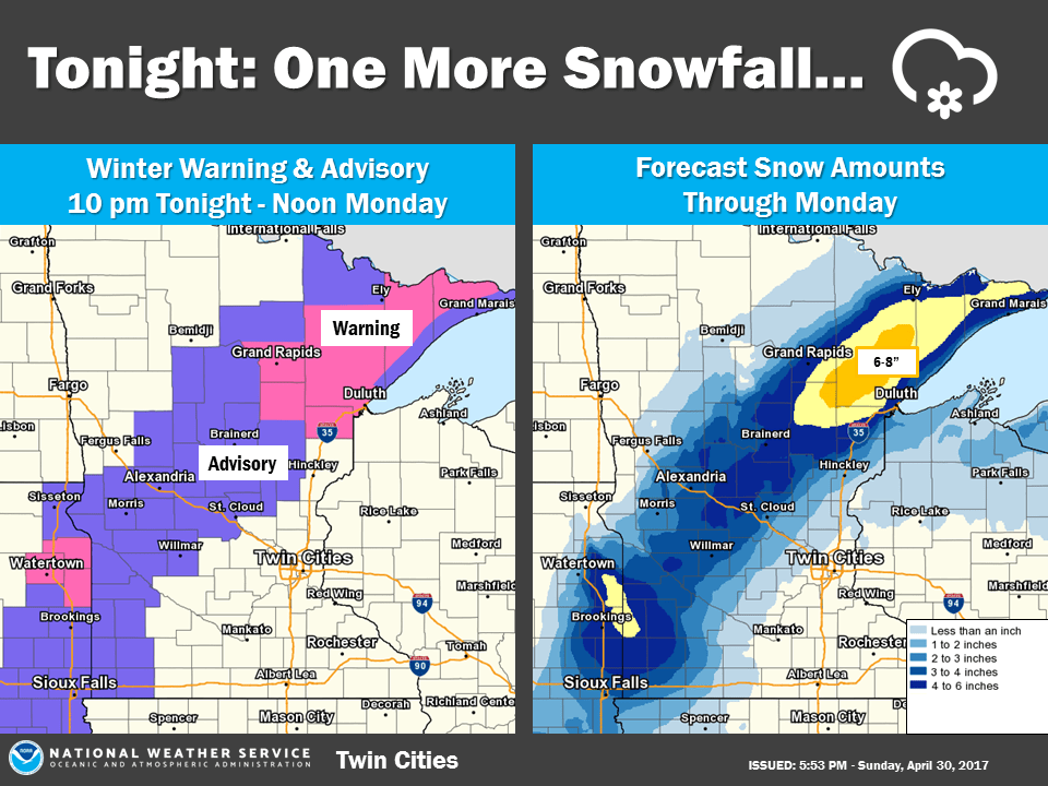
Advisories and winter storm warnings into Monday for parts of Minnesota
Sloppy wet snow will fall over parts of Minnesota as May begins.
Our Sunday evening rain will mix with snow, then change to all snow later Sunday night in parts of southwestern, central and northeastern Minnesota.
Those areas will see periods of snow on Monday as well.
The Twin Cities metro area and southeastern Minnesota will see mostly periods of rain Sunday night and Monday, but it could mix with or change to wet snow at times. Some minor snow accumulation is possible on grassy areas in the Twin Cities metro area on Monday.
Create a More Connected Minnesota
MPR News is your trusted resource for the news you need. With your support, MPR News brings accessible, courageous journalism and authentic conversation to everyone - free of paywalls and barriers. Your gift makes a difference.
The National Oceanic and Atmospheric Administration’s North American Mesoscale forecast model shows the potential precipitation pattern:

Green areas indicate rain, blue areas indicate snow.
The color chart to the right of the loop refers to the strength of the signal returning to the radar, not inches of snow!
Warnings and advisories
If enough cold air enters the storm circulation, significant snow could accumulate in parts of northeastern Minnesota, making travel difficult on Monday.
Southwestern Minnesota and west-central through central Minnesota could see a few inches of snow and some slippery roads.
Here is the snow potential from Sunday night through Monday night, from the Duluth office of the National Weather Service:

A winter storm warning is in effect for much of northeastern Minnesota from midnight Sunday night to 7 p.m. Monday:

Some details of the winter storm warning:
URGENT - WINTER WEATHER MESSAGE
National Weather Service Duluth MN
436 PM CDT Sun Apr 30 2017
...LATE WINTER STORM WILL BRING SIGNIFICANT SNOW ACCUMULATION TO
PORTIONS OF THE NORTHLAND...
.A late-season winter storm will affect the Northland starting
late tonight and continuing through Monday evening. An area of low
pressure over northeast Kansas this afternoon will advance
northeastward to southern Ontario by Tuesday morning. Rain will
mix with and eventually change to snow for portions of central
Minnesota tonight and in northeast Minnesota late tonight or
Monday morning. Snow rates of 1 inch per hour are likely from near
Aitkin and Grand Rapids, to the Iron Range, and interior portions
of the Arrowhead late tonight through Monday morning. The Monday
morning commute will be slow for some Northlanders due to snow
accumulation on roads and visibility less than one-half mile. As
temperatures warm slightly during the day, snow accumulation will
slow down as melting and compaction take on a more prominent role.
Precipitation may change back to rain as the rates diminish
during the late morning into the afternoon.
MNZ019-026-035-037-010745-
/O.UPG.KDLH.WW.Y.0020.170501T0500Z-170501T1700Z/
/O.NEW.KDLH.WS.W.0004.170501T0500Z-170502T0000Z/
Central St. Louis-South Itasca-Northern Aitkin-
Carlton/South St. Louis-
Including the cities of Hibbing, Grand Rapids, Hill City,
and Duluth
436 PM CDT Sun Apr 30 2017
...WINTER STORM WARNING IN EFFECT FROM MIDNIGHT TONIGHT TO 7 PM
CDT MONDAY...
The National Weather Service in Duluth has issued a Winter Storm
Warning for Heavy Snow...which is in effect from midnight tonight
to 7 PM CDT Monday.
* LOCATIONS...The heaviest snowfall and greatest accumulation will
occur inland from Lake Superior, west to near Grand Rapids, and
north to the Iron Range. A sharp gradient in snow accumulation
is expected from near Twig and Cloquet to locales in downtown
and west Duluth.
* TIMING...Rain will change to snow overnight with 1 inch per hour
snow rates possible during the Monday morning commute.
* SNOW ACCUMULATIONS...4 to 8 inches.
* WINDS...Northeast 10 to 15 mph with gusts up to 25 mph inland,
and northeast 15 to 20 mph with gusts to 30 mph near Lake
Superior.
* VISIBILITY...Less than one-quarter mile at times.
* IMPACTS...Roads, bridges, and walkways will become snow covered
and slippery. The combination of northeast winds and falling
snow will reduce visibility.
PRECAUTIONARY/PREPAREDNESS ACTIONS...
A Winter Storm Warning for heavy snow means significant snow
accumulation is anticipated, and snowfall rates of one inch per
hour or greater can be expected at times. Expect snow covered
roads and visibility less than a quarter mile. If you must
travel, exercise caution and allow extra time to reach your
destination. Tell someone your travel route and expected arrival
time and have a working cell phone in case you become stranded.
Keep a winter survival kit in your vehicle which includes a
flashlight, food, and water.
Much of southwestern, west-central and central Minnesota is in a winter weather advisory from 10 p.m. Sunday to noon on Monday:

Some advisory details, from the NWS:
URGENT - WINTER WEATHER MESSAGE
National Weather Service Twin Cities/Chanhassen MN
402 PM CDT Sun Apr 30 2017
...Wet Snow expected tonight across Western and Central
Minnesota...
.A Winter Weather Advisory is in effect from 10 PM through noon
Monday for western and central Minnesota. A heavy wet snow with
totals of 2 to 5 inches are possible, along with strong northeast
wind gusts of 25 to 35 mph. The heaviest snow will fall between 1
AM and 7 AM Monday morning. Plan for slippery roads and slow
travel.
MNZ041>045-047>050-054>057-064-010515-
/O.CON.KMPX.WW.Y.0011.170501T0300Z-170501T1700Z/
Douglas-Todd-Morrison-Mille Lacs-Kanabec-Stevens-Pope-Stearns-
Benton-Lac Qui Parle-Swift-Chippewa-Kandiyohi-Yellow Medicine-
Including the cities of Alexandria, Long Prairie, Little Falls,
Princeton, Mora, Morris, Glenwood, St Cloud, Foley, Madison,
Benson, Montevideo, Willmar, and Granite Falls
402 PM CDT Sun Apr 30 2017
...WINTER WEATHER ADVISORY REMAINS IN EFFECT FROM 10 PM THIS
EVENING TO NOON CDT MONDAY...
* Expect a snow to develop around 10 PM and then diminish around
noon Monday.
* The heaviest snowfall rates will occur between 1 AM and 7 AM
Monday.
* Total wet snow accumulations of 3 to 5 inches.
* Look for reduced visibilities at times.
* Plan on slippery road conditions...including during the
morning commute on Monday.
Precautionary/Preparedness actions...
A winter weather advisory means that periods of snow...sleet or
freezing rain will cause travel difficulties. Be prepared for
slippery roads and limited visibilities...and use caution while
driving. THE LATEST ROAD CONDITIONS FOR THE STATE YOU ARE CALLING
FROM CAN BE OBTAINED BY CALLING 5 1 1.
A summary of possible snow amounts statewide Sunday night through Monday, from the Twin Cities office of the NWS:
The timing of the arrival of cold air will have a big effect on snow amounts, so check back for weather updates.
Updates
Minnesota Public Radio will keep you updated on the wintry weather that develops in parts of Minnesota Sunday night and Monday.
Updated weather information will also be posted on the MPR news live weather blog.
You can also check with the Twin Cities office, Duluth office and Sioux Falls, SD office of the National Weather Service for weather updates. The NWS sites have clickable maps for the forecast at your specific location.
The Minnesota Department of Transportation will have current road conditions.
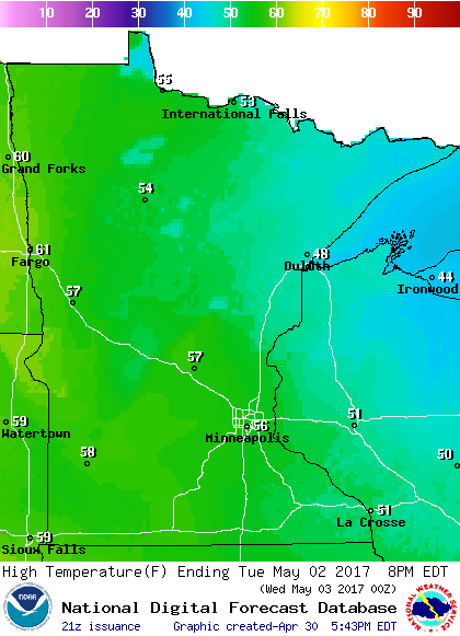
Temps recover
Monday will be cold, with afternoon highs in the upper 30s to lower 40s in most of Minnesota.
On Tuesday, many spots see highs in the 50s:
Wednesday is even warmer, with highs in the lower 60s in parts of southern Minnesota:

The Twin Cities metro area is expected to see see highs in the mid 60s on Thursday. We could reach the upper 60s on Friday and 70 degrees next weekend.
May outlook
The Climate Prediction Center of the NWS has released the May temperature outlook:

It shows equal chances of above normal and below normal monthly temps for most of Minnesota. There is a very slight tendency for a cooler than normal May in southeastern Minnesota.
By the way, despite very cool temps during the final few days of the month, April will be our 20th consecutive warmer than normal month in the Twin Cities metro area.
Details to follow.
Programming note
You can hear my live weather updates on Minnesota Public Radio at 7:49 a.m. Thursdays and Fridays, and at 7:35 and 9:35 a.m., plus 4:35 p.m., each Saturday and Sunday.