Winter storm warning much of southern Minn. Sunday; winter weather advisory SW metro starts Sunday afternoon
A low pressure system will track to our south Sunday and Sunday night, bringing snow to southern and central Minnesota. The heaviest snow is expected over southwestern and south-central Minnesota.
The National Oceanic and Atmospheric Administration’s Global Forecast System model shows the possible snow pattern, and the areas that could see the highest snow totals:

Purple shaded areas indicate potential accumulations of more than 6 inches.
Forecast plumes of several computer models show an average of about 4 inches of snow for Minneapolis-St. Paul International Airport (airport id KMSP):
Create a More Connected Minnesota
MPR News is your trusted resource for the news you need. With your support, MPR News brings accessible, courageous journalism and authentic conversation to everyone - free of paywalls and barriers. Your gift makes a difference.

The Twin Cities metro area could see a wide range of snow totals Sunday afternoon through Sunday night.
I wouldn’t be surprised if the far northeastern part of the 7 county metro area ends up with 1 to 3 inches of snow, while the far southwest metro sees some 4 to 6 inch totals.
A change in the track of the low pressure system will change snow amounts in Minnesota and western Wisconsin, so check for forecast updates.
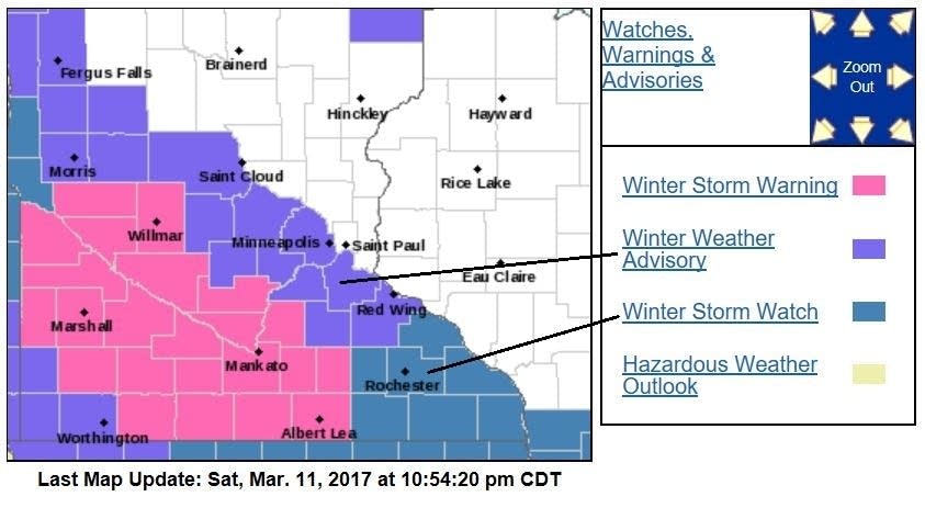
Warnings and advisories
A winter storm warning is in effect from 10 a.m. Sunday to 7 a.m. Monday for much of southwestern Minnesota and south-central Minnesota:

Here are some details of the winter storm warning:
URGENT - WINTER WEATHER MESSAGE
National Weather Service Twin Cities/Chanhassen MN
926 PM CST Sat Mar 11 2017
...HEAVY SNOW COMING SUNDAY FROM WEST CENTRAL INTO SOUTH CENTRAL
MINNESOTA...
.A winter storm warning is in effect Sunday afternoon through
Sunday night along the Minnesota River Valley in west central
Minnesota to the I-90 corridor in south central Minnesota. A
winter weather advisory is now in effect north of the warning up
to Alexandria, Minneapolis, and Red Wing.
Snowfall accumulations of 6 to 9 inches are expected within the
warning, with 3 to 6 inches anticipated within the advisory area.
Snow will begin moving into western Minnesota after 6am Monday
morning and move into the Twin Cities shortly after noon Sunday.
The heaviest snow is expected Sunday afternoon into the evening,
with snowfall slowly tapering off from northwest to southeast
Sunday night into Monday morning.
MNZ055>057-065-067-075-121130-
/O.UPG.KMPX.WS.A.0004.170312T1500Z-170313T1200Z/
/O.EXA.KMPX.WS.W.0003.170312T1500Z-170313T1200Z/
Swift-Chippewa-Kandiyohi-Renville-Sibley-Nicollet-
Including the cities of Benson, Montevideo, Willmar, Olivia,
Gaylord, and St Peter
926 PM CST Sat Mar 11 2017
...WINTER STORM WARNING IN EFFECT FROM 10 AM SUNDAY TO 7 AM CDT
MONDAY...
The National Weather Service in Twin Cities/Chanhassen has issued
a Winter Storm Warning for snow, which is in effect from 10 AM
Sunday to 7 AM CDT Monday. The Winter Storm Watch is no longer in
effect.
* Snow will quickly move in Sunday morning, with the heaviest snow
expected during Sunday afternoon. Snow will slowly taper off
after midnight Sunday night.
* Total snow accumulations of 6 to 9 inches are possible.
* Significant reductions in visibility are possible.
* Plan on difficult driving conditions.
Precautionary/Preparedness actions...
A winter storm warning for snow means severe winter weather
conditions are expected. If you must travel...keep an extra
flashlight...food and water in your vehicle in case of an
emergency. The latest road conditions for the state you are
calling from can be obtained by calling 5 1 1.
Three counties in far southwestern Minnesota are in a winter weather advisory Sunday and Sunday night:
URGENT - WINTER WEATHER MESSAGE
National Weather Service Sioux Falls SD
954 PM CST Sat Mar 11 2017
MNZ089-097-098-SDZ038>040-054>056-062-121200-
/O.CON.KFSD.WW.Y.0007.170312T1200Z-170313T0900Z/
Nobles-Pipestone-Rock-Beadle-Kingsbury-Brookings-Miner-Lake-Moody-
Minnehaha-
954 PM CST Sat Mar 11 2017
...WINTER WEATHER ADVISORY REMAINS IN EFFECT FROM 7 AM SUNDAY TO
4 AM CDT MONDAY...
* TIMING...Expect snow to develop around 7 AM Sunday and then
diminish around 4 AM Monday.
* PRECIPITATION RATES...The heaviest snowfall rates will occur
between noon and 6 PM Sunday.
* SNOW ACCUMULATIONS...Total snow accumulations of 3 to 7 inches
are expected.
* WINDS / VISIBILITIES...Look for reduced visibilities at times.
* IMPACTS...Plan on difficult driving conditions.
PRECAUTIONARY/PREPAREDNESS ACTIONS...
A winter weather advisory for snow means periods of snow will
cause primarily travel difficulties. be prepared for snow covered
roads and limited visibilities...and use caution while driving.
The latest road conditions for the state you are calling from can
be obtained by calling 5 1 1.
The southwestern half of the Twin Cities metro area is in a winter weather advisory from 1 p.m. Sunday to 1 p.m. Monday. In west-central Minnesota, a winter weather advisory begins at 7 a.m. Sunday:
Details of the advisory, from the Twin Cities office of the NWS:
MNZ059-060-068>070-077-078-121130-
/O.UPG.KMPX.WS.A.0004.170312T1800Z-170313T2100Z/
/O.NEW.KMPX.WW.Y.0009.170312T1800Z-170313T1800Z/
Wright-Hennepin-Carver-Scott-Dakota-Rice-Goodhue-
Including the cities of Monticello, Minneapolis, Chaska,
Shakopee, Hastings, Faribault, and Red Wing
926 PM CST Sat Mar 11 2017
...WINTER WEATHER ADVISORY IN EFFECT FROM 1 PM SUNDAY TO 1 PM CDT
MONDAY...
The National Weather Service in Twin Cities/Chanhassen has issued
a Winter Weather Advisory for snow, which is in effect from 1 PM
Sunday to 1 PM CDT Monday. The Winter Storm Watch is no longer in
effect.
* Snow will quickly move in after noon Sunday, with the heaviest
snow expected during Sunday afternoon into the evening. Snow
will slowly taper off late Sunday night into Monday morning.
* Total snow accumulations of 3 to 6 inches are expected.
* Plan on difficult driving conditions Sunday afternoon and evening.
PRECAUTIONARY/PREPAREDNESS ACTIONS...
A Winter Weather Advisory for snow means that periods of snow
will cause primarily travel difficulties. Be prepared for snow
covered roads and limited visibilities...and use caution while
driving.
Southeastern Minnesota is in a winter storm watch from 4 p.m. Sunday through Monday afternoon.
Here is a summary from the NWS, with possible snow totals from Sunday through early Monday:

Updates
Minnesota Public Radio will keep you updated on this winter storm.
Updated weather information will also be posted on the MPR news live weather blog.
You can also check with the Twin Cities office, La Crosse, WI office and Sioux Falls, SD office of the National Weather Service for weather updates. The NWS sites have clickable maps for the forecast at your specific location.
The Minnesota Department of Transportation and Wisconsin Department of Transportation will have current road conditions.
Programming note
You can hear my live weather updates on Minnesota Public Radio at 7:49 a.m. Fridays, and at 7:35 a.m. and 4:35 p.m. each Saturday and Sunday.