A new cloud; 40s through the weekend
Thursday was World Meteorological Day.
To help mark the event, the World Meteorological Association released an online version of their International Cloud Atlas:
The World Meteorological Organization (WMO) has released its new, long-awaited, digitized International Cloud Atlas – the global reference for observing and identifying clouds, which are an essential part of weather, the climate system and the water cycle.
Create a More Connected Minnesota
MPR News is your trusted resource for the news you need. With your support, MPR News brings accessible, courageous journalism and authentic conversation to everyone - free of paywalls and barriers. Your gift makes a difference.
The press release notes:
"The International Cloud Atlas is the single most authoritative and comprehensive reference for identifying clouds. Its reputation is legendary among cloud enthusiasts and it serves as an essential training tool for professionals working in meteorological services, and in sectors such as aviation and shipping,” said WMO Secretary-General Petteri Taalas.
This is the biggest update in the WMO cloud atlas in three decades.
There are several new clouds in the atlas:
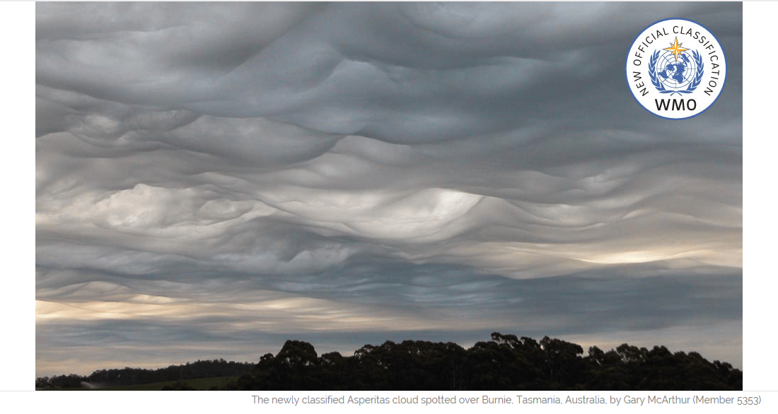
Best known of these is asperitas (from the Latin meaning roughness), Photographs of the dramatic, wave-like cloud captured the popular imagination around the world. The Cloud Appreciation Society argued for a new classification to be used to describe clouds with this appearance. The Atlas includes the winning photograph from a Cloud Appreciations Society competition on Asperitas.
Here's a great pic of "Asperitas", from the Cloud Appreciation Society website:
You can impress your friends with your knowledge of Asperitas this weekend!
The WMO International Cloud Atlas is a great source of info.
Rain tapers
The Twin Cities metro area could see a few scattered showers this Friday afternoon.
Periods of rain this are expected this Friday afternoon and Friday evening over south-central and southeastern Minnesota.
Southeastern Minnesota also has a chance of showers on Saturday.
A few scattered showers are possible statewide Saturday night and Sunday, with some areas of freezing rain also possible Saturday night in parts of northeastern Minnesota.
The National Oceanic and Atmospheric Administration’s North American Mesoscale forecast model shows the potential precipitation pattern from Saturday through Sunday:

There aren't any snowstorms in site over the next week or so.
Stuck in the 40s
Saturday highs will be in the 40s over most of Minnesota:

Many spots in northeastern Minnesota will top out in the upper 30s.
Sunday's highs will be similar to Saturday's highs, then milder temps return next week.
The Twin Cities area will warm into the lower 50s Monday and Tuesday, with upper 50s Wednesday. Computer models show highs in the 60s next Thursday.
Winter scorecard
Meteorological winter (December through February) was warmer than normal in Minnesota and Wisconsin.
Our mild winter wasn't predicted in the winter outlook that was issued by the Climate Prediction Center of the National Weather Service last fall.
NOAA released a national winter outlook scorecard this week:
According to their review:
The region where below-average temperatures were observed was west of where we thought it was likely to be.. Instead of being over the northern Plains, the colder-than-normal temperatures were instead over the Pacific Northwest. Close! But this isn’t darts.
I was among the local meteorologists who were skeptical of the Climate Prediction Center's outlook for a cold winter, partly because we were running very warm in October.
Our warm November made many people wonder when the turn to cold temps would happen.
It never did shift to a persistent cold pattern over Minnesota and Wisconsin.
The NWS winter outlook was most accurate over the southern part of the United States, where the forecast was for a warm winter.
Programming note
You can hear my live weather updates on Minnesota Public Radio at 7:49 a.m. Thursdays and Fridays, and at 7:35 a.m. and 4:35 p.m. each Saturday and Sunday.