Very warm today; winter storm watch begins Thursday evening
Breaking records is becoming old hat, with dozens of new record high temperatures around Minnesota over the past five days.
Yesterday's 62 degrees at Minneapolis-St. Paul International Airport was a record high temp, and we could tie or break our record high of 57 today:
Highs in the 40s are expected over southern Minnesota and the Twin Cities tomorrow, followed by lower 30s on Friday.
Near-normal temps will probably feel cool after the warm weather of the past couple of weeks.
Create a More Connected Minnesota
MPR News is your trusted resource for the news you need. With your support, MPR News brings accessible, courageous journalism and authentic conversation to everyone - free of paywalls and barriers. Your gift makes a difference.
Our average high temperature this time of year is only 31 degrees in the Twin Cities!
Snow returns late Thursday
We've only seen three-tenths of an inch of snow in the Twin Cities this month. Our 30-year average February snowfall total is 7.8 inches in the Twin Cities, so we're overdue to see some flakes.
We'll see a lot of flakes late Thursday night and Friday.
The National Oceanic and Atmospheric Administration’s Global Forecast System model shows the potential snowfall pattern:
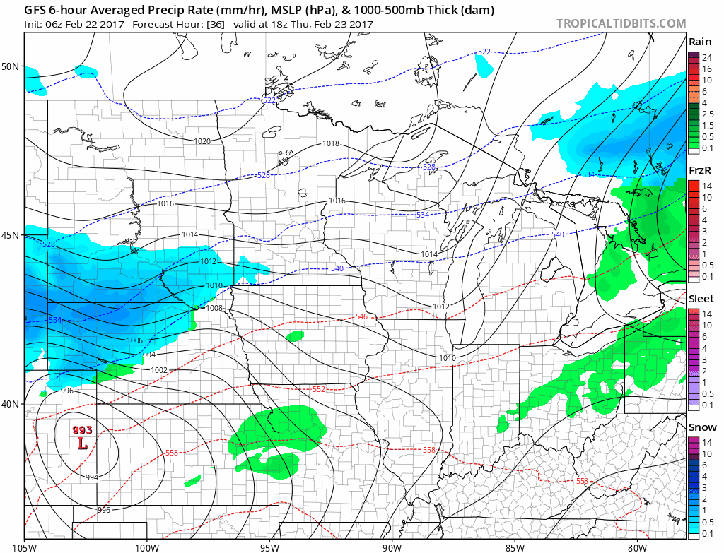
Blue shaded areas indicate snow, green shaded areas are rain.
The GFS model shows that a foot or more of snow could fall in parts of southern Minnesota and the Twin Cities metro area:

The precipitation could start as rain or a mix of rain and snow over southern Minnesota Thursday afternoon, then transition to mostly snow Thursday night.
Snow totals would be lower if that changeover to snow is delayed.
The National Weather Service has issued winter storm watches for much of central and southern Minnesota that begin at 6 p.m. Thursday and continue through Friday evening:

URGENT - WINTER WEATHER MESSAGE
National Weather Service Twin Cities/Chanhassen MN
407 AM CST Wed Feb 22 2017
...HIGH END WINTER STORM TAKING AIM AT THE UPPER MIDWEST THURSDAY
NIGHT THROUGH FRIDAY EVENING...BRINGING HEAVY SNOW...STRONG
WINDS...AND BLOWING SNOW...
.A winter storm watch has been expanded to include areas along and
southeast of an Appleton, to St. Cloud, to Mora Minnesota line
from Thursday evening through Friday evening. Snow accumulations
of 6 to 12 inches, with locally higher amounts are possible across
the watch area. In addition, northeast winds Friday morning
becoming north and northwest Friday afternoon will gust as high as
40 mph. Blowing snow will further reduce visibilities. If these
winds materialize, blizzard conditions should be expected in open
areas.
The Friday morning and afternoon commutes are expected to be
significantly impacted.
MNZ053-059>063-065>070-073>078-082>085-091-092-221815-
/O.EXT.KMPX.WS.A.0003.170224T0000Z-170225T0600Z/
Chisago-Wright-Hennepin-Anoka-Ramsey-Washington-Renville-McLeod-
Sibley-Carver-Scott-Dakota-Redwood-Brown-Nicollet-Le Sueur-Rice-
Goodhue-Watonwan-Blue Earth-Waseca-Steele-Martin-Faribault-
Including the cities of Center City, Monticello, Minneapolis,
Blaine, St Paul, Stillwater, Olivia, Hutchinson, Gaylord, Chaska,
Shakopee, Hastings, Redwood Falls, New Ulm, St Peter, Le Sueur,
Faribault, Red Wing, St James, Mankato, Waseca, Owatonna,
Fairmont, and Blue Earth
407 AM CST Wed Feb 22 2017
...WINTER STORM WATCH NOW IN EFFECT FROM THURSDAY EVENING THROUGH
FRIDAY EVENING...
* TIMING...Rain will turn to heavy snow Thursday evening and
continue through Friday.
* SNOW ACCUMULATIONS...6 to 12 inches are likely, with amounts
in excess of 12 inches possible.
* WINDS...Northeast to northwest 20 to 30 mph with gusts to 40
mph resulting in considerable blowing snow and possible
blizzard conditions.
PRECAUTIONARY/PREPAREDNESS ACTIONS...
A Winter Storm Watch means there is a potential for significant
snow...sleet...or ice accumulations that may impact travel.
Continue to monitor the latest forecasts.
The European Centre for Medium-Range Weather Forecasts model has the highest snow totals shifted southward.
The snow forecast plumes of various versions of NOAA's GFS and North American Mesoscale Forecast System models have snow totals for the Twin Cities (FAA id KMSP) in the 5- to 15-inch range.

Be prepared for the biggest snow totals of the winter season over much of southern and central Minnesota and on into Wisconsin.
According to the Twin Cities office of the NWS, the last time that we received a foot of snow at Minneapolis-St. Paul International Airport was Feb. 20-21, 2011.
Even a half a foot of snow would cause some major traffic problems on Friday, so plan ahead.
We'll keep you updated on the latest computer model info for this snowstorm.