Saturday snow northern MN; winter storm possible Tuesday
Snow lovers are waiting for more flakes.
So far this snow season, we've tallied 26.8 inches of snow at Minneapolis-St. Paul International Airport, which is about 8 inches behind our normal pace.
According to the Minnesota State Climatology Office and the Twin Cities office of the National Weather Service, the first week of February is the time of year that our snow depth typically peaks in the metro area:
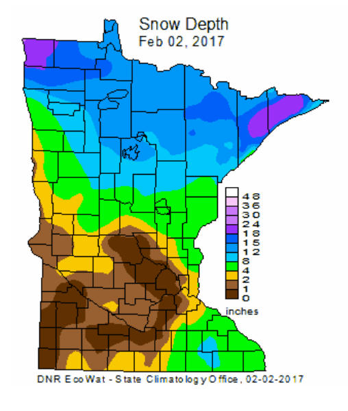
The weekly snow depth map from the Minnesota State Climatology Office shows very little snow on the ground in the Twin Cities metro area and much of southern Minnesota:
Create a More Connected Minnesota
MPR News is your trusted resource for the news you need. With your support, MPR News brings accessible, courageous journalism and authentic conversation to everyone - free of paywalls and barriers. Your gift makes a difference.
We do have the potential for a plowable snow for much of Minnesota on Tuesday.
Snow north on Saturday
The National Oceanic and Atmospheric Administration’s North American Mesoscale forecast model shows a low pressure system spreading snow over much of northern Minnesota and parts of central Minnesota on Saturday:

The color chart on the lower right of the loop refers to the strength of the radar signal returning to the radar, not inches of snow!
Parts of northeastern and north-central Minnesota and northwestern Wisconsin could see 2 or 3 inches of snow. There’s a chance of light snow or flurries in the Twin Cities on Saturday, especially late in the day.
Here is the projected Saturday and Saturday evening snowfall pattern, from the Duluth NWS:

Some roads in northern Minnesota could become slick.
Mild temps Saturday
Highs will be in the 30s Saturday over most of southern and central Minnesota:

Most of northern Minnesota will top out in the 20s.
It'll be breezy on Saturday, so it probably won't feel as warm as the air temperature.
Sunday highs will drop back into the teens in the north, with 20s in the south:

The Twin Cities metro area will see lower 30s again on Monday and Tuesday.
Potential Tuesday snowstorm
The latest run of NOAA’s Global Forecast System model continues to show a low pressure system passing to our south and southeast next Tuesday through Tuesday night, dropping snow over much of Minnesota and Wisconsin:

If this forecast model is correct, most of Minnesota and Wisconsin will see enough snow to shovel and plow Tuesday into Tuesday night.
Southern Minnesota and the Twin Cities metro area could see a wintry mix of rain/freezing rain/sleet and snow early Tuesday, then a changeover to all snow.
A slightly more southerly track of the low-pressure system would generate all snow for Minnesota.
At this point, I’d call it a potential winter storm for next Tuesday and Tuesday night.
Forecast maps could change quite a bit as we get closer to Tuesday, so check back for later updates.
Programming note
You can hear my live weather updates on Minnesota Public Radio at 7:49 a.m. Fridays, and at 7:35 a.m. and 4:35 p.m. each Saturday and Sunday.