Near Miss: Storm tracking mostly south of Twin Cities
Here's a quick update based on tonight's radar, satellite, surface reports, and model trends.
All indications are the storm system dumping heavy snow across southern Minnesota is tracking even further south. That means most of the accumulating snow will miss a large part of the Twin Cities Friday.
Latest Twin Cities radar loop
Create a More Connected Minnesota
MPR News is your trusted resource for the news you need. With your support, MPR News brings accessible, courageous journalism and authentic conversation to everyone - free of paywalls and barriers. Your gift makes a difference.

That's good news for your Friday commutes, but not as welcome for snow lovers. Any significant snowfall accumulations now look to be confined to the southeast metro.

The Twin Cities NWS has dropped winter storm warnings for the south and east metro, and replaced them with winter weather advisories. Blizzard warnings continue for southern Minnesota.
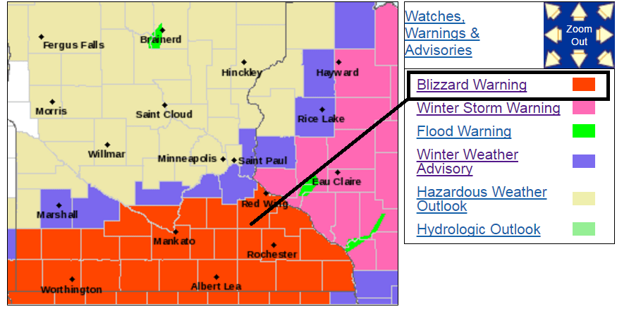
Including the cities of New Ulm, St Peter, Le Sueur, Faribault, Red Wing, St James, Mankato, Waseca, Owatonna, Fairmont, Blue Earth, and Albert Lea
834 PM CST Thu Feb 23 2017
...BLIZZARD WARNING REMAINS IN EFFECT UNTIL 6 AM CST SATURDAY...
* TIMING...Heavy snow will develop later this evening, with increasing winds on Friday.
* SNOW ACCUMULATIONS...6 to 12 inches are expected, with the heaviest totals along the Iowa border.
* WINDS/VISIBILITY...North 25 to 35 mph with gusts to 45 mph resulting in considerable blowing snow and possible whiteout conditions.
Meteorologists Note: Overall model performance on this storm looks dismal.
The Euro basically handled this storm the best of all models. NOAA's suite of models, especially NAM-based products had tremendous error factors on placement of heavy snowfall bands. Many MAM outputs this week placed the heavy snow bands northwest of or into the Twin Cities this week, which we recognized as likely being in error in Wednesday's Updraft post.
"NOAA’s NAM model brings the heaviest snow band right into the heart of the metro. But many meteorologists note the NAM model often has a northward bias on storm track."
NOAA's GFS did better by indicating the heavy snow bands would be south of the MSP metro. But even the GFS was too far north.
Overall a disappointing model performance after fairly good forecast model performance earlier this winter. At this point it's hard to say why the U.S. models did such a poor job with this system. My best guess is the extreme warmth and jet stream displacement of the past two weeks were too far out of whack for them to recover accurately.