Advisory northeastern MN through Saturday; snow and wind Tuesday
Snowflakes are falling over much of northern Minnesota as we begin the weekend.
The National Oceanic and Atmospheric Administration’s North American Mesoscale forecast model shows a low pressure system bringing snow to northern Minnesota and parts of central Minnesota today:
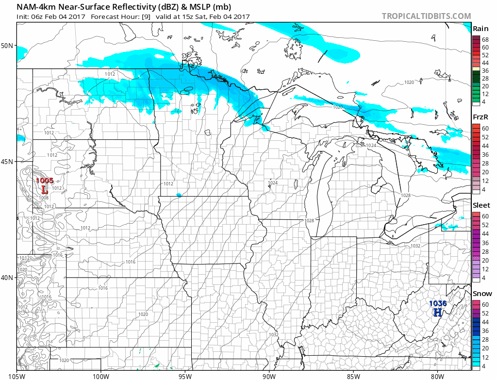
The color chart on the lower right of the loop refers to the strength of the radar signal returning to the radar, not inches of snow!
The most likely area to see 2 or more inches of snow today into this evening will be northeastern Minnesota:
Create a More Connected Minnesota
MPR News is your trusted resource for the news you need. With your support, MPR News brings accessible, courageous journalism and authentic conversation to everyone - free of paywalls and barriers. Your gift makes a difference.

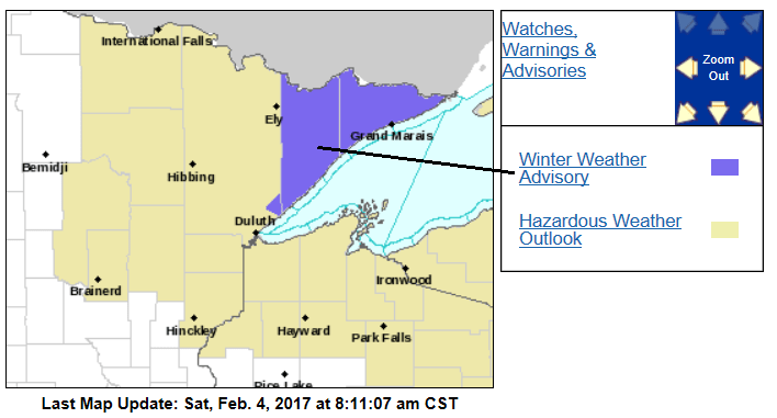
The Duluth office of the National Weather Service has issued a winter weather advisory for Cook and Lake counties of northeastern Minnesota until 6 p.m. Saturday:
Here are some advisory details:
URGENT - WINTER WEATHER MESSAGE
NATIONAL WEATHER SERVICE DULUTH MN
629 AM CST SAT FEB 4 2017
...QUICK BURST OF LIGHT TO MODERATE SNOW THIS MORNING INTO THE
AFTERNOON...
.A WARM FRONT ASSOCIATED WITH A LOW PRESSURE SYSTEM WILL LIFT
INTO NORTHERN MINNESOTA TODAY LEADING TO A PERIOD OF LIGHT TO
MODERATE SNOWFALL. FOR AREAS ACROSS THE MINNESOTA ARROWHEAD A
BRIEF PERIOD OF MODERATE TO AT TIMES HEAVY SNOWFALL WILL BE
POSSIBLE...LEADING TO REDUCED VISIBILITY AND ROADS QUICKLY
BECOMING SNOW COVERED.
MNZ012-020-021-050000-
/O.CON.KDLH.WW.Y.0007.170204T1500Z-170205T0000Z/
NORTHERN COOK/NORTHERN LAKE-SOUTHERN LAKE/NORTH SHORE-
SOUTHERN COOK/NORTH SHORE-
INCLUDING THE CITIES OF...ISABELLA...TWO HARBORS...SILVER BAY...
GRAND MARAIS
629 AM CST SAT FEB 4 2017
...WINTER WEATHER ADVISORY REMAINS IN EFFECT UNTIL 6 PM CST THIS
EVENING...
* LOCATIONS...THE MINNESOTA ARROWHEAD INCLUDING TWO HARBORS...
SILVER BAY...AND GRAND MARAIS. SNOWFALL AMOUNTS ARE EXPECTED
TO BE GREATEST ACROSS THE HIGHER TERRAIN OF THE NORTH SHORE.
* TIMING...SNOWFALL RAPIDLY DEVELOPS MID TO LATE MORNING...WITH
A PERIOD OF MODERATE TO AT TIMES HEAVY SNOWFALL IN THE EARLY
AFTERNOON. SNOWFALL RATES DECREASE MID TO LATE AFTERNOON...AND
ALL SNOW COMES TO AN END THIS EVENING.
* SNOW ACCUMULATIONS...2 TO 5 INCHES.
* VISIBILITIES...A HALF MILE OR LESS AT TIMES THIS MORNING INTO
THE EARLY AFTERNOON.
* IMPACTS...MODERATE TO AT TIMES HEAVY SNOWFALL RATES MAY REDUCE
VISIBILITY AND CAUSE SNOWFALL TO QUICKLY ACCUMULATE ON AREA
ROADS.
PRECAUTIONARY/PREPAREDNESS ACTIONS...
A WINTER WEATHER ADVISORY FOR SNOW MEANS THAT ACCUMULATING SNOW
WILL CAUSE TRAVEL DIFFICULTIES. BE PREPARED FOR SNOW COVERED
ROADS AND REDUCED VISIBILITY...AND USE CAUTION WHILE DRIVING.
ALLOW EXTRA TIME TO REACH YOUR DESTINATION.
Some spots in northwestern Minnesota could see around an inch of snow today.
Occasional flurries are possible in southern Minnesota and the Twin Cities metro area.
Mild Saturday highs
Highs will be in the 30s today over most of southern and central Minnesota:
Northern Minnesota will top out in the 20s.
Don't be surprised if a 40 degree reading pops up in southwestern Minnesota.
Sunday highs will drop back into the teens in the north, with 20s in the south:
The Twin Cities metro area will see highs in the lower 30s on Monday and Tuesday.
Potential Tuesday snowstorm
The latest run of NOAA’s Global Forecast System model continues to show a low pressure system passing to our south and southeast next Tuesday through Tuesday night, dropping snow over much of Minnesota and Wisconsin:

If this forecast model is correct, most of Minnesota and Wisconsin will see enough snow to shovel and plow Tuesday into Tuesday night.
Southern Minnesota and the Twin Cities metro area could see a wintry mix of light rain/drizzle/light freezing rain/freezing drizzle/sleet and snow early Tuesday, then a changeover to all snow.
A slightly more southerly track of the low-pressure system would generate all snow for Minnesota.
We'll keep you updated on this potential winter storm.
Programming note
At Minnesota Public Radio, we monitor the weather seven days a week.
You can hear live weekend weather updates with MPR meteorologists at 7:35 a.m. and 4:35 p.m. each Saturday and Sunday.