Single digit highs; no big snows
We're living the single life.
Minnesota high temps will be in the single digits below zero in the north today, single digits above zero in the south.
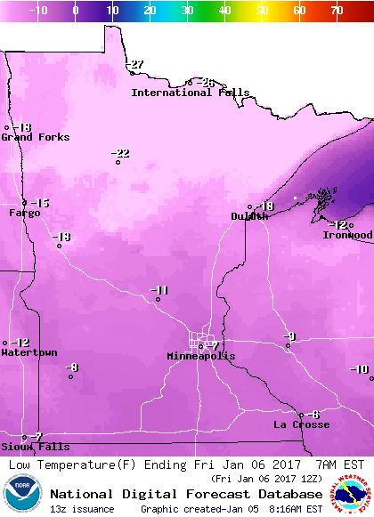
Northern Minnesota will see the coldest low temps Friday morning, in the 20s below zero:
Highs Friday will be in the single digits above zero in most areas, but some spots in the far north might stay below zero:
Create a More Connected Minnesota
MPR News is your trusted resource for the news you need. With your support, MPR News brings accessible, courageous journalism and authentic conversation to everyone - free of paywalls and barriers. Your gift makes a difference.

Single digit highs are likely over most of Minnesota on Saturday.
We complete our weekend with highs in the upper teens on Sunday in southern Minnesota, but it'll be another day with single digit highs in the north.
Warm temps in sight
The inevitable warmup happens next week.
The National Oceanic and Atmospheric Administration's Global Forecast System model shows the temperature at 2 meters above the ground popping int0 the 20s over southern Minnesota on Tuesday and into the lower 30s on Wednesday:

As is often the case in January, warmer temps will be accompanied by some snowflakes.
NOAA's GFS model shows the possible snowfall pattern on Tuesday:

At this point, it doesn't look like a big storm, but some areas could have enough to shovel.
Does your car feel the wind chill?
Wind chill advisories continue until noon today for most of Minnesota and western Wisconsin.
Here's the National Weather Service definition of wind chill:
The wind chill temperature is how cold people and animals feel when outside. Wind chill is based on the rate of heat loss from exposed skin caused by wind and cold. As the wind increases, it draws heat from the body, driving down skin temperature and eventually the internal body temperature. Therefore, the wind makes it feel much colder.
Temperature and wind speed are the two variables that go into the wind chill calculation, and the results look like this:

It's interesting that the formula does not take sunshine into account. Bright sunshine could diminish the wind chill effect by a few degrees. Then again, a runner who runs into the wind could cause a bit more of a wind chill effect.
You can use the wind chill calculator to figure out how cold the wind chill is in your area, if you know the temperature and wind speed.
Your car, or other inanimate objects, will not "feel" the wind chill temperature.
As explained by the NWS:
The only effect wind chill has on inanimate objects, such as car radiators and water pipes, is to more quickly cool the object to the current air temperature. The object will NOT cool below the actual air temperature. For example, if the temperature outside is -5°F and the wind chill temperature is -31°F, then your car's radiator will not drop lower than -5°F.
If you have the option, parking your car facing away from a strong wind could keep your engine block from reaching the air temperature as quickly as it would if the car was facing into the wind.
If the car is going to be sitting out all night, facing into the wind or away from the wind isn't likely to make much of a difference.