Icy and turning sharply colder
The freezing drizzle that fell yesterday and overnight has left many surfaces across central Minnesota including the Twin Cities ice-covered. Most freeways are mainly just wet, but sidewalks, driveways and neighborhood streets are quite icy.
Winter storm warnings
Meanwhile, winter storm warnings continue for parts of northern Minnesota. Several inches of fluffy snow have fallen across the north. Although the snowfall has just about ended, winds are picking up and will lead to considerable blowing and drifting, especially in northwestern Minnesota.
A winter storm warning continues for northwestern Minnesota until noon today.
Create a More Connected Minnesota
MPR News is your trusted resource for the news you need. With your support, MPR News brings accessible, courageous journalism and authentic conversation to everyone - free of paywalls and barriers. Your gift makes a difference.

A winter storm warning is posted by the Duluth National Weather Service for a small part of north central Minnesota and most of the Arrowhead until 6 p.m. today.

Arctic air on its way
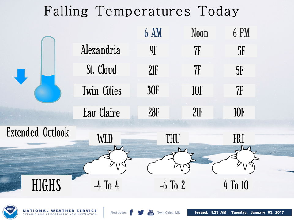
Much colder air is rushing our way from Canada. While the Twin Cities' temperature at 6 a.m. this morning was hanging on at 29 degrees, Fosston, Minn., in the northwest was already down to a wind-blown zero degrees.
Today will be windy and much colder across the state.
The Twin Cities will see temperatures plunge into the single digits by late afternoon, courtesy of northwest winds of 15 to 25 mph with stronger gusts. Skies will have some partial clearing, but the weak sunshine will not help much.

The bigger picture of forecast temperatures for this afternoon shows the coldest temperatures on their way in the light silver-blue color.

The coldest air is likely to be here on Thursday, as shown by the big blue high pressure center over the Northern Plains.

How long will it last?
The depths of the cold air will be Wednesday through Friday. Highs in the Twin Cities are likely to be around 4 degrees on Wednesday, 2 on Thursday and 8 on Friday. The weekend will bring slight relief.
Forecast maps are indicating a strong warm-up to near-seasonal high temperatures next Monday across southern and central Minnesota.