Windy and cold today; winter weather advisory NW Minnesota
Wintry weather will be with us for awhile .
The low pressure system that brought heavy snow and blizzard conditions to much of northwestern Minnesota yesterday is now sitting just north of Lake Superior.
The low will continue to give Minnesota strong winds and cold temperatures today. Wind chill temperatures will be near zero in many locations, so you'll want to find your warmest gloves or mittens.
The Grand Forks, N.D., forecast office of the National Weather Service has issued a winter weather advisory for northwestern Minnesota until 6 p.m. today. Periods of light snow and blowing snow will reduce visibilities in northwestern Minnesota:
Create a More Connected Minnesota
MPR News is your trusted resource for the news you need. With your support, MPR News brings accessible, courageous journalism and authentic conversation to everyone - free of paywalls and barriers. Your gift makes a difference.
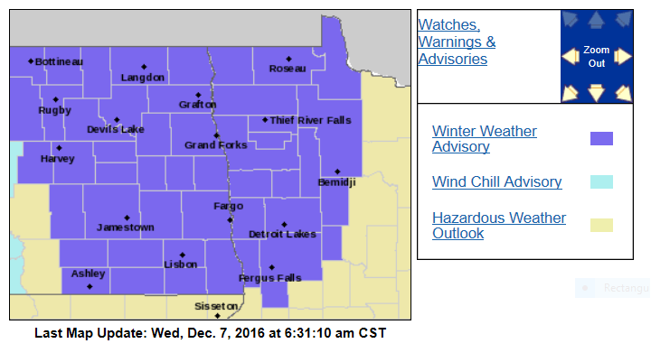
Here are more details, from the Grand Forks, ND office of the NWS:
URGENT - WINTER WEATHER MESSAGE
NATIONAL WEATHER SERVICE GRAND FORKS ND
602 AM CST WED DEC 7 2016
MNZ001>004-007-008-013>015-022-027-029-030-040-NDZ006>008-014>016-
024-026>030-039-049-052>054-080000-
/O.EXP.KFGF.BZ.W.0004.000000T0000Z-161207T1200Z/
/O.CON.KFGF.WW.Y.0011.000000T0000Z-161208T0000Z/
WEST POLK-NORMAN-CLAY-KITTSON-WEST MARSHALL-EAST MARSHALL-
PENNINGTON-RED LAKE-EAST POLK-MAHNOMEN-WEST BECKER-WILKIN-
WEST OTTER TAIL-GRANT-TOWNER-CAVALIER-PEMBINA-BENSON-RAMSEY-
EASTERN WALSH COUNTY-EDDY-NELSON-GRAND FORKS-GRIGGS-STEELE-TRAILL-
CASS-RANSOM-SARGENT-RICHLAND-WESTERN WALSH COUNTY-
INCLUDING THE CITIES OF...CROOKSTON...EAST GRAND FORKS...ADA...
TWIN VALLEY...HALSTAD...MOORHEAD...HALLOCK...KARLSTAD...
LANCASTER...WARREN...STEPHEN...ARGYLE...NEWFOLDEN...
MIDDLE RIVER...GRYGLA...THIEF RIVER FALLS...RED LAKE FALLS...
FOSSTON...FERTILE...MCINTOSH...ERSKINE...MAHNOMEN...NAYTAHWAUSH...
WAUBUN...DETROIT LAKES...BRECKENRIDGE...FERGUS FALLS...
ELBOW LAKE...HOFFMAN...ASHBY...HERMAN...BARRETT...CANDO...
LANGDON...CAVALIER...WALHALLA...DRAYTON...PEMBINA...NECHE...
ST. THOMAS...FORT TOTTEN...MADDOCK...LEEDS...MINNEWAUKAN...
DEVILS LAKE...GRAFTON...PARK RIVER...NEW ROCKFORD...LAKOTA...
MCVILLE...ANETA...TOLNA...GRAND FORKS...COOPERSTOWN...FINLEY...
HOPE...MAYVILLE...HILLSBORO...HATTON...PORTLAND...FARGO...
LISBON...ENDERLIN...GWINNER...MILNOR...FORMAN...RUTLAND...
WAHPETON...EDINBURG...ADAMS...LANKIN
602 AM CST WED DEC 7 2016
...WINTER WEATHER ADVISORY REMAINS IN EFFECT UNTIL 6 PM CST THIS
EVENING...
...BLIZZARD WARNING WILL EXPIRE AT 6 AM CST EARLY THIS MORNING...
* IMPACTS...AREAS OF LIGHT SNOW AND BLOWING AND DRIFTING SNOW
TODAY WILL CAUSE LOCALLY REDUCED VISIBILITIES.
* ADDITIONAL SNOW ACCUMULATIONS...AROUND AN 1 INCH.
* WINDS...NORTHWEST 25 TO 35 MPH WITH GUSTS UP TO 45 MPH.
* VISIBILITIES...LOCALLY ONE HALF MILE OR LESS.
* WIND CHILL VALUES...5 BELOW TO 15 BELOW ZERO.
PRECAUTIONARY/PREPAREDNESS ACTIONS...
A WINTER WEATHER ADVISORY FOR BLOWING SNOW MEANS THAT
VISIBILITIES WILL BE LIMITED DUE TO STRONG WINDS BLOWING SNOW
AROUND. USE CAUTION WHEN TRAVELING...ESPECIALLY IN OPEN AREAS.
Central, northeastern and southern Minnesota will see occasional flurries today.
Here’s the simulated radar for today from the National Oceanic and Atmospheric Administration’s 4km resolution North American Mesoscale forecast model:

Cold stretch
Our average high this time of year is 30 degrees in the Twin Cities metro area.
We aren’t likely to see 30s again anytime soon.
Minnesota highs will be in the teens to lower 20s today:

Similar highs are expected tomorrow:

Here's a timely cold weather reminder from the Twin Cities office of the National Weather Service:
Highs in the teens will be common on Friday, then mid 20s could return to southern Minnesota on Saturday.
We could see a shot of real cold air early next week, with one forecast model showing highs in the lower teens next Monday and Tuesday over southern Minnesota. Northern Minnesota could see some single digit highs early next week.
There's a very good chance that colder than normal temps will linger into the third week of December:
Our average temperature during the first 6 days of December was 8.3 degrees above normal in the Twin Cities.
The forecast cool spell will offset the early December warmth, and this could be our first cooler than normal month in the Twin Cities since August of 2015.
Weekend snow
Central and southern Minnesota could see enough snow to shovel and plow this weekend.
NOAA's Global Forecast System model shows snow spreading across Minnesota Saturday afternoon and continuing into Sunday morning:

The heaviest snow would tend to be across southern Minnesota.
NOAA's various models show anywhere from 1 to 9 inches of snow for the Twin Cities by Saturday evening:

The average snow total is about 3 inches.
We'll see how the models change as we get closer to the weekend.
This one could make snow-lovers in southern Minnesota very happy.