Warmest November on record so far, wintry whispers ahead
This is getting a little crazy.
68 degrees - high temp at MSP Airport Thursday
69 degrees - record high at MSP for Thursday
+23 degrees vs. average for November 10th
+14 degrees vs. average so far in November at MSP
Warmest November on record so far across much of Minnesota
Thermometers spiked into the 60s again across Minnesota Thursday afternoon. 68 degrees at Twin Cities Airport on November 10th? That's the average high temperatures for September 24th folks.
Create a More Connected Minnesota
MPR News is your trusted resource for the news you need. With your support, MPR News brings accessible, courageous journalism and authentic conversation to everyone - free of paywalls and barriers. Your gift makes a difference.
Temperatures ran about 15 degrees warmer than average in Minnesota for the first week of November. More than 500 warm temperature records have fallen this week across the Midwest.
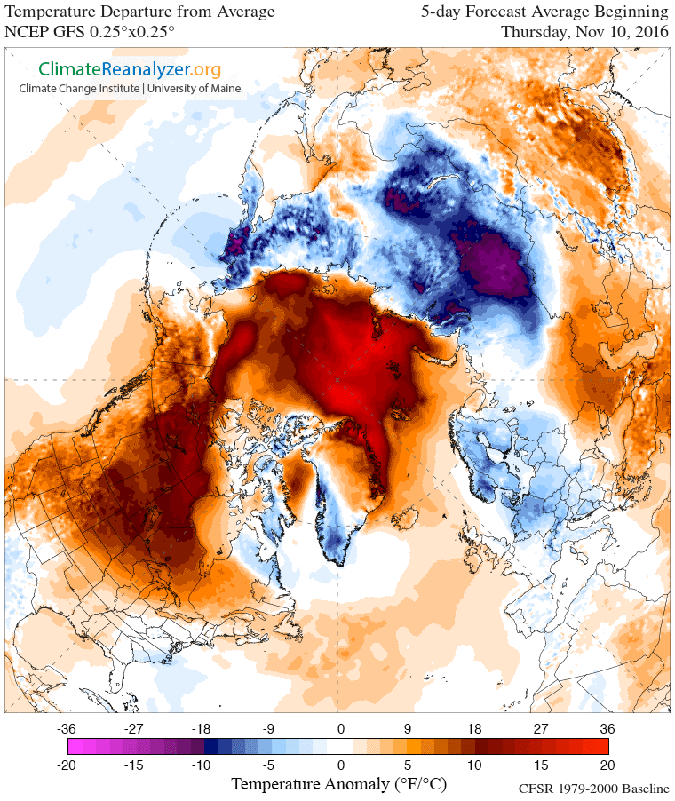
The weather maps continue to look like somebody dropped a bucket of red paint over North America and the Arctic. Temperatures continue to run 20 to 30 degrees warmer than average from Minnesota to the Arctic.
Warmest start to November on record
This is the warmest first 10 days of November on record for Minnesota. The lowest temp at MSP Airport has been just 36 degrees this fall. In fact, we've never seen overnight low temperatures stay so warm this late in the fall season in Minnesota. Another way of looking at it, this is the latest start to fall/winter on record.
You hear the UM's Dr. Mark Seeley Friday mornings on MPR News. Here's a little preview of what Mark will be talking about Friday morning.
Topic: Warmest first ten days of November
The remarkable warmth so far this month is record-setting. For example in the Twin Cities, the average temperature for the first ten days of November is 53.7°. This is nearly 14°F above normal and surpasses the other warm first ten days of November which occurred in 1975, 2001, and 2015. This pattern is holding true at a number of locations around the state, including International Falls where the first ten days of November are average close to 46°F also about 14°F above normal. This too surpasses the other warmest Novembers of 1964, 1975, and 2015.
So far this month 32 daily high temperature records have been set within the Minnesota Cooperative Weather Observer Network across the state, including a remarkable reading of 78°F at Mora (Kanabec County) on the 5th which tied the all-time state high temperature record for that date (set at Madison in Lac Qui Parle County back in 1975). In addition a handful of warmest overnight minimum temperature records have been set this month, including a low of 48°F at Winona on the 2nd.
Kenny Blumenfeld of the State Climatology Office also notes that most observers around the state have reported record-setting warm minimum temperatures for the autumn season so far, even though nearly all have reported frosts as well. For the Twin Cities "...36°F on the 9th is the warmest fall-to-date (Sep 1 – Nov 9) minimum temperature ever recorded in the Twin Cities......the next warmest is 31°F." Furthermore he notes "...This record is quite stable geographically. Milan and Waseca both broke their warmest fall-to-date minimum records this year, at 27°F and 28°F, respectively. Rochester, St. Cloud, Pipestone, Duluth, Morris, and Grand Rapids did it too. In other words, the coldest nights of fall have never been this warm...."
Cool front arrives
Another weak, almost nondescript cool front blew through Minnesota Thursday. Cooler, but still above average temps arrive Friday. Milder southwest winds return this weekend.

Our string of sunny dry days continues. Temps still run a good 10 degrees warmer than average this weekend. Saturday morning could produce the first 32 degree temp at MSP Airport. Another million-dollar fall weekend is on the way.

La Niña is here
Temperatures officially reached La Niña criteria this week in the tropical Pacific. Typically odds favor a colder and snowier winter in Minnesota during La Niña winters.
Given current and long term climate trends I remain skeptical. My winter outlook still calls for near to slightly warmer than average temps across Minnesota this winter.
Stay tuned.