Mostly 30s for our Friday; into the 40s this weekend
Our official high temp at Minneapolis-St. Paul International Airport was 37 degrees on Thanksgiving day.
We can be thankful that it wasn't 5 or 6 degrees cooler near the ground, or that mix of wet snow and light rain would have caused slick roads and sidewalks.
Our Friday highs will be in the 30s over most of Minnesota, with a few lower 40s possible in the southwest.
Mild weekend
Create a More Connected Minnesota
MPR News is your trusted resource for the news you need. With your support, MPR News brings accessible, courageous journalism and authentic conversation to everyone - free of paywalls and barriers. Your gift makes a difference.
Highs in the 40s are expected over much of southern Minnesota on Saturday:
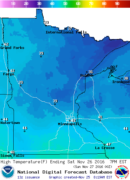
Upper 30s are on tap for northern Minnesota.
On Sunday, central and southern Minnesota will see highs in the 40s:

Upper 30s are expected over the north.
Sunday night rain
We'll be on the warm side of the next low pressure system that tracks through the Upper Midwest.
Because of the mild air, there is a good chance that we’ll see some periods of rain (rather than snow) over much of Minnesota from Sunday evening through Monday evening.
Here is the rain pattern, as depicted by NOAA’s Global Forecast System (GFS) model:

The rain could change to snow over northern Minnesota later Monday night.
Some areas in eastern North Dakota could see periods of heavy snow on Monday.
Drought update
The latest update from U.S. Drought Monitor shows that no part of Minnesota is experiencing drought conditions:

Extreme to exceptional drought conditions are found in much of central and southern California, and from northern Louisiana to the western parts of North Carolina and South Carolina.
In the Twin Cities, our precipitation (rain plus the water content of our snow) is 7.71 inches above normal so far this year.
Programming note
You can hear my live weather updates on Minnesota Public Radio at 7:35 a.m. and 4:35 p.m. each Saturday and Sunday.